Property Record
50 Hatchetts Hill Rd, Old Lyme, CT 06371


NEARBY LISTINGS FOR SALE OR LEASE
-
-
View all Old Lyme listings for sale on LoopNet.com
Property Detail
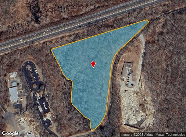
50 Hatchetts Hill Rd
OLYM-000019-000000-000028
New London
Industrialacreage
Connecticut
X
28
09011C0459J
8.96 AC
2025
SW New London/East Lyme
2025
Hartford
660103
Norwich-New London, CT
1,108 SF
DEMOGRAPHICS near 50 Hatchetts Hill Rd
1 Mile
3 Mile
5 Mile
2024 Total Population
1,053
13,310
29,235
2029 Population
1,055
13,525
29,598
Pop Growth 2024-2029
+ 0.19%
+ 1.62%
+ 1.24%
Average Age
45
47
47
2024 Total Households
321
5,369
12,366
HH Growth 2024-2029
(1.25%)
+ 1.64%
+ 1.29%
Median Household Inc
$106,991
$105,231
$106,701
Avg Household Size
2.30
2.20
2.20
2024 Avg HH Vehicles
2.00
2.00
2.00
Median Home Value
$402,027
$380,329
$385,693
Median Year Built
1981
1967
1967
Nearby Places
Map Layers
Map Styles
 Street
 Aerial
- Restaurants
- Banks
- Shops
- Fitness
- Groceries
PUBLIC TRANSPORTATION
COMMUTER RAIL
Old Saybrook (Shore Line East - Shore Line East)
DRIVE
WALK
Distance
Old Saybrook (Shore Line East - Shore Line East)
11 min
7.7 mi
Freight Ports
Port of New Haven
DRIVE
WALK
Distance
Port of New Haven
45 min
35.6 mi
SALE & LEASE HISTORY
LISTING DATE
SALE/LEASE

Jan 03, 2020
For Sale
Dec 18, 2018
For Sale
Nearby Properties
Address
Land Use
TOTAL SIZE
Lot Size
Zoning
Address
Land Use
TOTAL SIZE
Lot Size
Zoning
1,256 SF
64.84 AC
R40
Address
Land Use
TOTAL SIZE
Lot Size
Zoning
617.95 AC
Address
Land Use
TOTAL SIZE
Lot Size
Zoning
511.78 AC
R40
Address
Land Use
TOTAL SIZE
Lot Size
Zoning
106 AC
R40
Address
Land Use
TOTAL SIZE
Lot Size
Zoning
122,580 SF
15.18 AC
Address
Land Use
TOTAL SIZE
Lot Size
Zoning
18.40 AC
R80
Address
Land Use
TOTAL SIZE
Lot Size
Zoning
51,544 SF
10.75 AC
RU40
Address
Land Use
TOTAL SIZE
Lot Size
Zoning
23.41 AC
LI
Address
Land Use
TOTAL SIZE
Lot Size
Zoning
56,568 SF
3.65 AC
LI
Address
Land Use
TOTAL SIZE
Lot Size
Zoning
12,682 SF
3.81 AC
RU40
Address
Land Use
TOTAL SIZE
Lot Size
Zoning
11.62 AC
LI80
Address
Land Use
TOTAL SIZE
Lot Size
Zoning
25,088 SF
8.10 AC
LI80
Address
Land Use
TOTAL SIZE
Lot Size
Zoning
5.01 AC
IND
Address
Land Use
TOTAL SIZE
Lot Size
Zoning
38,837 SF
2.15 AC
R40
Address
Land Use
TOTAL SIZE
Lot Size
Zoning
41,563 SF
4.20 AC
Address
Land Use
TOTAL SIZE
Lot Size
Zoning
0.93 AC
RU40
Address
Land Use
TOTAL SIZE
Lot Size
Zoning
43,175 SF
3.83 AC
R40
Address
Land Use
TOTAL SIZE
Lot Size
Zoning
29,920 SF
7.64 AC
LI80
Address
Land Use
TOTAL SIZE
Lot Size
Zoning
159.75 AC
Address
Land Use
TOTAL SIZE
Lot Size
Zoning
33,000 SF
5.83 AC
R40
Address
Land Use
TOTAL SIZE
Lot Size
Zoning
26,496 SF
17.05 AC
LI
Address
Land Use
TOTAL SIZE
Lot Size
Zoning
2.08 AC
LI
Address
Land Use
TOTAL SIZE
Lot Size
Zoning
29,880 SF
3.84 AC
LI
Address
Land Use
TOTAL SIZE
Lot Size
Zoning
7,540 SF
4.65 AC
CA
Address
Land Use
TOTAL SIZE
Lot Size
Zoning
1.72 AC
C-30
Address
Land Use
TOTAL SIZE
Lot Size
Zoning
2,880 SF
0.58 AC
R-10
Address
Land Use
TOTAL SIZE
Lot Size
Zoning
1.86 AC
CA
Address
Land Use
TOTAL SIZE
Lot Size
Zoning
24,098 SF
4.46 AC
LI80
Address
Land Use
TOTAL SIZE
Lot Size
Zoning
7,047 SF
37.30 AC
RU40
Address
Land Use
TOTAL SIZE
Lot Size
Zoning
0.43 AC
R-10
The World's #1 Commercial Real Estate Marketplace
Connect with us
© 2025 CoStar Group
The information above has been obtained from sources believed reliable. While we do not doubt its accuracy we have not verified it and make no guarantee, warranty or representation about it. It is your responsibility to independently confirm its accuracy and completeness. Any projections, opinions, assumptions, or estimates used are for example only and do not represent the current or future performance of the property. The value of this transaction to you depends on tax and other factors which should be evaluated by your tax, financial, and legal advisors. You and your advisors should conduct a careful, independent investigation of the property to determine to your satisfaction the suitability of the property for your needs.