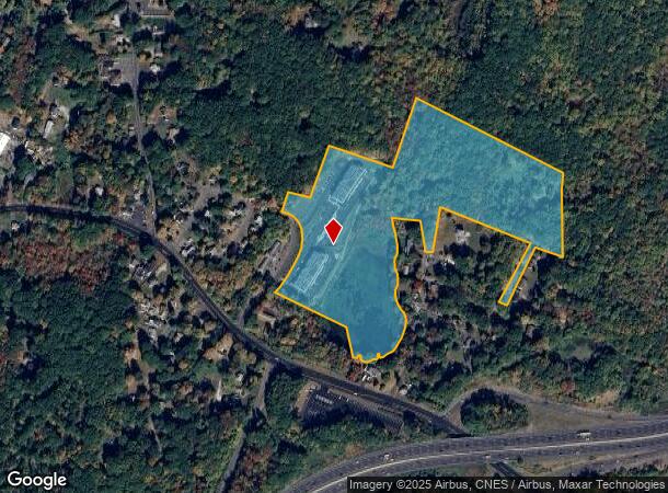
Property Record
50 Hazel Dr, Cheshire, CT 06410

NEARBY LISTINGS FOR SALE OR LEASE
Property Detail
50 Hazel Dr
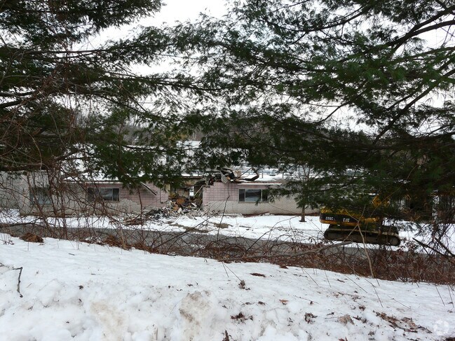
Apartmenthouse100plusunits
New Haven
X
Connecticut
09009C0137H
22.20 AC
2025
Cheshire
2025
Westchester/So Connecticut
343200
New Haven, CT
25,844 SF
CHES-000015-000052
DEMOGRAPHICS near 50 Hazel Dr
1 mile
3 mile
5 mile
2024 Total Population
3,893
37,263
131,417
2029 Population
3,906
37,097
130,901
Pop Growth 2024-2029
+ 0.33%
(0.45%)
(0.39%)
Average Age
39
41
40
2024 Total Households
1,577
14,762
50,162
HH Growth 2024-2029
+ 0.25%
(0.50%)
(0.41%)
Median Household Inc
$70,830
$75,374
$65,361
Avg Household Size
2.40
2.50
2.50
2024 Avg HH Vehicles
2.00
2.00
2.00
Median Home Value
$247,435
$252,350
$262,841
Median Year Built
1973
1967
1963
Nearby Places
Map Layers
Map Styles
 Street
 Aerial
Transit
 Traffic
 Biking
Places
Listings with unknown addresses are not visible on the map
- Restaurants
- Banks
- Shops
- Fitness
- Groceries
PUBLIC TRANSPORTATION
COMMUTER RAIL
Waterbury Station (New Haven Line - Metro-North Commuter Railroad Company (Metro-North))
Drive
Walk
Distance
Waterbury Station (New Haven Line - Metro-North Commuter Railroad Company (Metro-North))
9 min
5.9 mi
Naugatuck Station (New Haven Line - Metro-North Commuter Railroad Company (Metro-North))
Drive
Walk
Distance
Naugatuck Station (New Haven Line - Metro-North Commuter Railroad Company (Metro-North))
14 min
8.6 mi
AIRPORT
Tweed/New Haven
Drive
Walk
Distance
Tweed/New Haven
37 min
23.5 mi
Freight Ports
Port of New Haven
Drive
Walk
Distance
Port of New Haven
32 min
21.2 mi
Nearby Properties
Address
Land Use
TOTAL SIZE
Lot Size
Zoning
Address
Land Use
TOTAL SIZE
Lot Size
Zoning
77.50 AC
RS
Address
Land Use
TOTAL SIZE
Lot Size
Zoning
313,293 SF
53.21 AC
I-1
Address
Land Use
TOTAL SIZE
Lot Size
Zoning
97,386 SF
53.20 AC
RS
Address
Land Use
TOTAL SIZE
Lot Size
Zoning
73,961 SF
27.36 AC
I-2
Address
Land Use
TOTAL SIZE
Lot Size
Zoning
12.49 AC
CA
Address
Land Use
TOTAL SIZE
Lot Size
Zoning
31.75 AC
CA
Address
Land Use
TOTAL SIZE
Lot Size
Zoning
10.51 AC
RL
Address
Land Use
TOTAL SIZE
Lot Size
Zoning
91,324 SF
22.27 AC
RM
Address
Land Use
TOTAL SIZE
Lot Size
Zoning
25,474 SF
20.35 AC
RM
Address
Land Use
TOTAL SIZE
Lot Size
Zoning
15.39 AC
RM
Address
Land Use
TOTAL SIZE
Lot Size
Zoning
152,704 SF
17.09 AC
CA
Address
Land Use
TOTAL SIZE
Lot Size
Zoning
81,501 SF
19 AC
R-30
Address
Land Use
TOTAL SIZE
Lot Size
Zoning
5.10 AC
RM
Address
Land Use
TOTAL SIZE
Lot Size
Zoning
95,030 SF
14.30 AC
RA-1
Address
Land Use
TOTAL SIZE
Lot Size
Zoning
115,996 SF
19.57 AC
CA
Address
Land Use
TOTAL SIZE
Lot Size
Zoning
281,623 SF
39.24 AC
I-2
Address
Land Use
TOTAL SIZE
Lot Size
Zoning
35,200 SF
8.55 AC
B
Address
Land Use
TOTAL SIZE
Lot Size
Zoning
154,629 SF
18.76 AC
CA
Address
Land Use
TOTAL SIZE
Lot Size
Zoning
4,368 SF
13.97 AC
RM
Address
Land Use
TOTAL SIZE
Lot Size
Zoning
59,531 SF
2.70 AC
CA
Address
Land Use
TOTAL SIZE
Lot Size
Zoning
6.39 AC
RM
Address
Land Use
TOTAL SIZE
Lot Size
Zoning
61,173 SF
3.60 AC
RL
Address
Land Use
TOTAL SIZE
Lot Size
Zoning
90,198 SF
21.32 AC
CA
Address
Land Use
TOTAL SIZE
Lot Size
Zoning
172,891 SF
75 AC
I-2
Address
Land Use
TOTAL SIZE
Lot Size
Zoning
241,500 SF
16.93 AC
I-1
Address
Land Use
TOTAL SIZE
Lot Size
Zoning
45,768 SF
2.59 AC
RL
Address
Land Use
TOTAL SIZE
Lot Size
Zoning
62,889 SF
10.97 AC
CA
Address
Land Use
TOTAL SIZE
Lot Size
Zoning
8.02 AC
CA
Address
Land Use
TOTAL SIZE
Lot Size
Zoning
4.76 AC
RM
The World's #1 Commercial Real Estate Marketplace
Connect with us
© 2026 CoStar Group
The information above has been obtained from sources believed reliable. While we do not doubt its accuracy we have not verified it and make no guarantee, warranty or representation about it. It is your responsibility to independently confirm its accuracy and completeness. Any projections, opinions, assumptions, or estimates used are for example only and do not represent the current or future performance of the property. The value of this transaction to you depends on tax and other factors which should be evaluated by your tax, financial, and legal advisors. You and your advisors should conduct a careful, independent investigation of the property to determine to your satisfaction the suitability of the property for your needs.