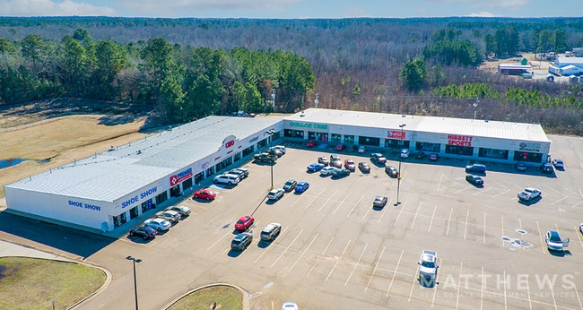
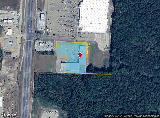
Property Record
50 Highway 79 N, Magnolia, AR 71753
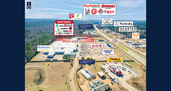
NEARBY LISTINGS FOR SALE OR LEASE
Property Detail
50 Highway 79 N
Magnolia, AR
Hollensworth Meadows S/D Replat Of Lot 8
01-06910-00000
HOLLENSWORTH MEADOWS S/D REPLAT OF LOTS 8 AND 9 LOT 8 BOOK 354 PAGE 629 50 HWY 79 LOT 8 OF THE REPLAT OF LOTS 8 AND 9 OF THE
Stripcommercialcenter
Columbia
X
Arkansas
05027C0190C
8
2025
2.82 AC
2025
Arkansas South Area
950100
Other Market Areas
35,680 SF
DEMOGRAPHICS near 50 Highway 79 N
1 Mile
3 Mile
5 Mile
2024 Total Population
2,189
12,225
13,806
2029 Population
2,141
12,073
13,597
Pop Growth 2024-2029
(2.19%)
(1.24%)
(1.51%)
Average Age
40
37
38
2024 Total Households
966
4,659
5,320
HH Growth 2024-2029
(2.17%)
(0.77%)
(1.13%)
Median Household Inc
$44,696
$35,770
$37,182
Avg Household Size
2.20
2.20
2.20
2024 Avg HH Vehicles
2.00
2.00
2.00
Median Home Value
$146,842
$133,246
$137,401
Median Year Built
1971
1972
1973
Nearby Places
Map Layers
Map Styles
 Street
 Aerial
- Restaurants
- Banks
- Shops
- Fitness
- Groceries
SALE & LEASE HISTORY
LISTING DATE
SALE/LEASE

Mar 15, 2023
For Sale
Jun 26, 2023
For Sale
Nearby Properties
Address
Land Use
TOTAL SIZE
Lot Size
Zoning
Address
Land Use
TOTAL SIZE
Lot Size
Zoning
432,882 SF
16.37 AC
Address
Land Use
TOTAL SIZE
Lot Size
Zoning
156,106 SF
17.99 AC
Address
Land Use
TOTAL SIZE
Lot Size
Zoning
19,314 SF
9.50 AC
Address
Land Use
TOTAL SIZE
Lot Size
Zoning
44,014 SF
15.20 AC
Address
Land Use
TOTAL SIZE
Lot Size
Zoning
37,516 SF
1.69 AC
Address
Land Use
TOTAL SIZE
Lot Size
Zoning
109,820 SF
13.67 AC
Address
Land Use
TOTAL SIZE
Lot Size
Zoning
25,848 SF
0.57 AC
Address
Land Use
TOTAL SIZE
Lot Size
Zoning
33,104 SF
2 AC
Address
Land Use
TOTAL SIZE
Lot Size
Zoning
40,496 SF
Address
Land Use
TOTAL SIZE
Lot Size
Zoning
2,172 SF
6.36 AC
Address
Land Use
TOTAL SIZE
Lot Size
Zoning
25,900 SF
12 AC
Address
Land Use
TOTAL SIZE
Lot Size
Zoning
32,705 SF
2.50 AC
Address
Land Use
TOTAL SIZE
Lot Size
Zoning
65,394 SF
6.98 AC
Address
Land Use
TOTAL SIZE
Lot Size
Zoning
67,332 SF
3.45 AC
Address
Land Use
TOTAL SIZE
Lot Size
Zoning
282,499 SF
9.08 AC
Address
Land Use
TOTAL SIZE
Lot Size
Zoning
74,783 SF
7.26 AC
Address
Land Use
TOTAL SIZE
Lot Size
Zoning
43,913 SF
2.40 AC
Address
Land Use
TOTAL SIZE
Lot Size
Zoning
20,024 SF
2.95 AC
Address
Land Use
TOTAL SIZE
Lot Size
Zoning
1,288 SF
9.25 AC
Address
Land Use
TOTAL SIZE
Lot Size
Zoning
42,336 SF
5.35 AC
Address
Land Use
TOTAL SIZE
Lot Size
Zoning
9,320 SF
7.08 AC
Address
Land Use
TOTAL SIZE
Lot Size
Zoning
55,580 SF
2.29 AC
Address
Land Use
TOTAL SIZE
Lot Size
Zoning
14,796 SF
0.82 AC
Address
Land Use
TOTAL SIZE
Lot Size
Zoning
118,818 SF
7.88 AC
Address
Land Use
TOTAL SIZE
Lot Size
Zoning
1,263 SF
4 AC
Address
Land Use
TOTAL SIZE
Lot Size
Zoning
14,980 SF
1.76 AC
Address
Land Use
TOTAL SIZE
Lot Size
Zoning
31,702 SF
1.55 AC
Address
Land Use
TOTAL SIZE
Lot Size
Zoning
35,292 SF
Address
Land Use
TOTAL SIZE
Lot Size
Zoning
8,361 SF
5.32 AC
The World's #1 Commercial Real Estate Marketplace
Connect with us
© 2026 CoStar Group
The information above has been obtained from sources believed reliable. While we do not doubt its accuracy we have not verified it and make no guarantee, warranty or representation about it. It is your responsibility to independently confirm its accuracy and completeness. Any projections, opinions, assumptions, or estimates used are for example only and do not represent the current or future performance of the property. The value of this transaction to you depends on tax and other factors which should be evaluated by your tax, financial, and legal advisors. You and your advisors should conduct a careful, independent investigation of the property to determine to your satisfaction the suitability of the property for your needs.