Property Record
50 Iron Gate Rd, Clarksville, VA 23927
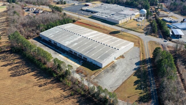

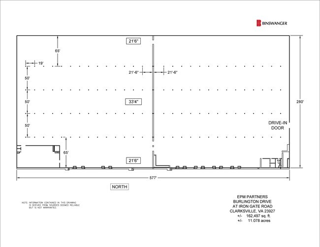
Property Detail
50 Iron Gate Rd
Multipleuses
PR. KINDERTON TR
M1
Mecklenburg
B and X Area of moderate flood hazard, usually the area between the limits of the 100-year and 500-year floods.
Virginia
2025
11.08 AC
2025
Virginia South Central
930800
Other Market Areas
159,620 SF
9264
NEARBY LISTINGS FOR SALE OR LEASE
-
-
View all Clarksville listings for lease on LoopNet.com
DEMOGRAPHICS near 50 Iron Gate Rd
1 mile
3 mile
5 mile
2025 Total Population
345
2,342
4,104
2030 Population
350
2,366
4,164
Pop Growth 2025-2030
+ 1.45%
+ 1.02%
+ 1.46%
Average Age
49
49
49
2025 Total Households
165
1,080
1,884
HH Growth 2025-2030
+ 1.21%
+ 0.93%
+ 1.38%
Median Household Inc
$52,500
$57,384
$56,204
Avg Household Size
2.00
2.10
2.10
2025 Avg HH Vehicles
2.00
2.00
2.00
Median Home Value
$293,181
$306,716
$310,126
Median Year Built
1973
1972
1974
Nearby Places
Map Layers
Map Styles
 Street
 Aerial
Layers
 Traffic
 Biking
Places
Listings with unknown addresses are not visible on the map
- Restaurants
- Banks
- Shops
- Fitness
- Groceries
SALE & LEASE HISTORY
LISTING DATE
SALE/LEASE

Jul 27, 2021
For Lease
Nearby Properties
Address
Land Use
TOTAL SIZE
Lot Size
Zoning
Address
Land Use
TOTAL SIZE
Lot Size
Zoning
195,965 SF
14.35 AC
M1
Address
Land Use
TOTAL SIZE
Lot Size
Zoning
79,999 SF
19.74 AC
R2
Address
Land Use
TOTAL SIZE
Lot Size
Zoning
2,304 SF
400 AC
AG
Address
Land Use
TOTAL SIZE
Lot Size
Zoning
46,147 SF
7.34 AC
B1
Address
Land Use
TOTAL SIZE
Lot Size
Zoning
25,541 SF
5 AC
B1
Address
Land Use
TOTAL SIZE
Lot Size
Zoning
51,385 SF
16.46 AC
B1
Address
Land Use
TOTAL SIZE
Lot Size
Zoning
4,716 SF
216.66 AC
R1
Address
Land Use
TOTAL SIZE
Lot Size
Zoning
5,440 SF
1.33 AC
B2
Address
Land Use
TOTAL SIZE
Lot Size
Zoning
0.59 AC
R3
Address
Land Use
TOTAL SIZE
Lot Size
Zoning
280 SF
4.90 AC
B1
Address
Land Use
TOTAL SIZE
Lot Size
Zoning
22,150 SF
4.90 AC
I1
Address
Land Use
TOTAL SIZE
Lot Size
Zoning
18,576 SF
29.20 AC
AG
Address
Land Use
TOTAL SIZE
Lot Size
Zoning
52,836 SF
6.84 AC
B1
Address
Land Use
TOTAL SIZE
Lot Size
Zoning
22,254 SF
2.13 AC
B2
Address
Land Use
TOTAL SIZE
Lot Size
Zoning
2,082 SF
5.67 AC
R2
Address
Land Use
TOTAL SIZE
Lot Size
Zoning
28,860 SF
2 AC
B2
Address
Land Use
TOTAL SIZE
Lot Size
Zoning
7,000 SF
2.22 AC
B1
Address
Land Use
TOTAL SIZE
Lot Size
Zoning
13,225 SF
2 AC
B1
Address
Land Use
TOTAL SIZE
Lot Size
Zoning
8,875 SF
1.30 AC
B2
Address
Land Use
TOTAL SIZE
Lot Size
Zoning
9,617 SF
3.44 AC
B1
Address
Land Use
TOTAL SIZE
Lot Size
Zoning
1,302 SF
6.78 AC
B1
Address
Land Use
TOTAL SIZE
Lot Size
Zoning
11,106 SF
2.24 AC
B1
Address
Land Use
TOTAL SIZE
Lot Size
Zoning
4,448 SF
1.72 AC
B1
Address
Land Use
TOTAL SIZE
Lot Size
Zoning
87.66 AC
M1
Address
Land Use
TOTAL SIZE
Lot Size
Zoning
15,778 SF
10 AC
B1
Address
Land Use
TOTAL SIZE
Lot Size
Zoning
1,696 SF
99.27 AC
M1
Address
Land Use
TOTAL SIZE
Lot Size
Zoning
7,569 SF
3.01 AC
B1
Address
Land Use
TOTAL SIZE
Lot Size
Zoning
9,647 SF
0.66 AC
B2
Address
Land Use
TOTAL SIZE
Lot Size
Zoning
20,033 SF
0.96 AC
B1
The World's #1 Commercial Real Estate Marketplace
Connect with us
© 2026 CoStar Group
The information above has been obtained from sources believed reliable. While we do not doubt its accuracy we have not verified it and make no guarantee, warranty or representation about it. It is your responsibility to independently confirm its accuracy and completeness. Any projections, opinions, assumptions, or estimates used are for example only and do not represent the current or future performance of the property. The value of this transaction to you depends on tax and other factors which should be evaluated by your tax, financial, and legal advisors. You and your advisors should conduct a careful, independent investigation of the property to determine to your satisfaction the suitability of the property for your needs.