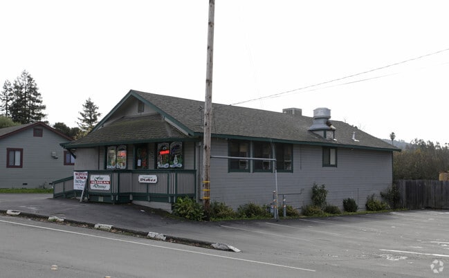
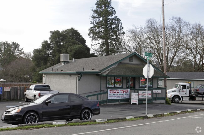
Property Record
50 Knudtsen Ln, Petaluma, CA 94952

NEARBY LISTINGS FOR SALE OR LEASE
Property Detail
50 Knudtsen Ln
021-024-065
2002 FM PT 021-024-060 2001R179955
Retailwithmorethanonenonretailuse
Sonoma
AE
California
06041C0150D
2.30 AC
2024
Petaluma/Cotati/Rohnert
2025
North Bay/Santa Rosa
151000
Santa Rosa, CA
2,789 SF
DEMOGRAPHICS near 50 Knudtsen Ln
1 Mile
3 Mile
5 Mile
2024 Total Population
3,554
44,455
68,361
2029 Population
3,426
43,795
67,150
Pop Growth 2024-2029
(3.60%)
(1.48%)
(1.77%)
Average Age
47
44
44
2024 Total Households
1,437
17,798
26,628
HH Growth 2024-2029
(3.62%)
(1.48%)
(1.78%)
Median Household Inc
$128,780
$107,403
$110,034
Avg Household Size
2.40
2.40
2.50
2024 Avg HH Vehicles
2.00
2.00
2.00
Median Home Value
$999,999
$804,816
$795,821
Median Year Built
1963
1978
1978
Nearby Places
Map Layers
Map Styles
 Street
 Aerial
- Restaurants
- Banks
- Shops
- Fitness
- Groceries
PUBLIC TRANSPORTATION
COMMUTER RAIL
DRIVE
WALK
Distance
5 min
2.0 mi
DRIVE
WALK
Distance
10 min
4.0 mi
AIRPORT
Charles M Schulz - Sonoma County
DRIVE
WALK
Distance
Charles M Schulz - Sonoma County
36 min
24.9 mi
Freight Ports
Port of Richmond
DRIVE
WALK
Distance
Port of Richmond
50 min
34.7 mi
Nearby Properties
Address
Land Use
TOTAL SIZE
Lot Size
Zoning
Address
Land Use
TOTAL SIZE
Lot Size
Zoning
231,609 SF
8.05 AC
Address
Land Use
TOTAL SIZE
Lot Size
Zoning
121,876 SF
16.14 AC
Address
Land Use
TOTAL SIZE
Lot Size
Zoning
5.03 AC
CITYPE
Address
Land Use
TOTAL SIZE
Lot Size
Zoning
150,025 SF
1.48 AC
Address
Land Use
TOTAL SIZE
Lot Size
Zoning
165,541 SF
12.61 AC
Address
Land Use
TOTAL SIZE
Lot Size
Zoning
149,242 SF
5.40 AC
CITYPE
Address
Land Use
TOTAL SIZE
Lot Size
Zoning
137,270 SF
10.04 AC
Address
Land Use
TOTAL SIZE
Lot Size
Zoning
94,107 SF
2.66 AC
Address
Land Use
TOTAL SIZE
Lot Size
Zoning
89,944 SF
14.63 AC
CITYPE
Address
Land Use
TOTAL SIZE
Lot Size
Zoning
170,524 SF
14.53 AC
Address
Land Use
TOTAL SIZE
Lot Size
Zoning
1.18 AC
Address
Land Use
TOTAL SIZE
Lot Size
Zoning
151,942 SF
5.85 AC
Address
Land Use
TOTAL SIZE
Lot Size
Zoning
80,392 SF
7.13 AC
Address
Land Use
TOTAL SIZE
Lot Size
Zoning
195,837 SF
16.32 AC
PCD
Address
Land Use
TOTAL SIZE
Lot Size
Zoning
85,582 SF
2.61 AC
CITYPE
Address
Land Use
TOTAL SIZE
Lot Size
Zoning
Address
Land Use
TOTAL SIZE
Lot Size
Zoning
71,220 SF
7.31 AC
CITYPE
Address
Land Use
TOTAL SIZE
Lot Size
Zoning
138,520 SF
10.36 AC
ML
Address
Land Use
TOTAL SIZE
Lot Size
Zoning
0.96 AC
MG
Address
Land Use
TOTAL SIZE
Lot Size
Zoning
70,110 SF
1.11 AC
CITYPE
Address
Land Use
TOTAL SIZE
Lot Size
Zoning
93,700 SF
6.02 AC
ML
Address
Land Use
TOTAL SIZE
Lot Size
Zoning
41,302 SF
1.43 AC
CITYPE
Address
Land Use
TOTAL SIZE
Lot Size
Zoning
81,975 SF
5 AC
Address
Land Use
TOTAL SIZE
Lot Size
Zoning
88,482 SF
7.29 AC
Address
Land Use
TOTAL SIZE
Lot Size
Zoning
64,568 SF
0.87 AC
Address
Land Use
TOTAL SIZE
Lot Size
Zoning
83,880 SF
5 AC
ML
Address
Land Use
TOTAL SIZE
Lot Size
Zoning
49,549 SF
4.02 AC
CITYPE
Address
Land Use
TOTAL SIZE
Lot Size
Zoning
43,050 SF
1.38 AC
Address
Land Use
TOTAL SIZE
Lot Size
Zoning
7.52 AC
The World's #1 Commercial Real Estate Marketplace
Connect with us
© 2025 CoStar Group
The information above has been obtained from sources believed reliable. While we do not doubt its accuracy we have not verified it and make no guarantee, warranty or representation about it. It is your responsibility to independently confirm its accuracy and completeness. Any projections, opinions, assumptions, or estimates used are for example only and do not represent the current or future performance of the property. The value of this transaction to you depends on tax and other factors which should be evaluated by your tax, financial, and legal advisors. You and your advisors should conduct a careful, independent investigation of the property to determine to your satisfaction the suitability of the property for your needs.