Property Record
50 Ledge Rd, Darien, CT 06820
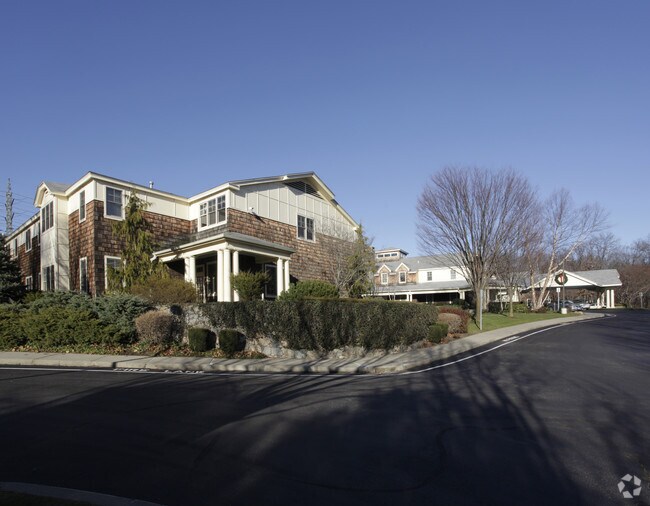

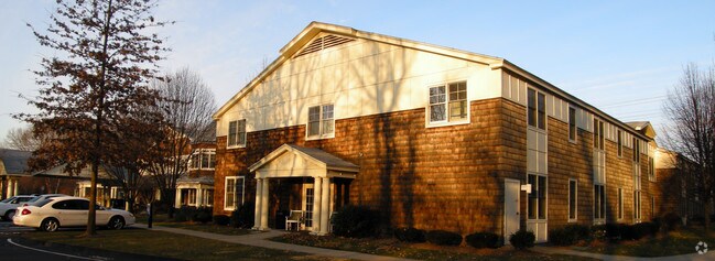
Property Detail
50 Ledge Rd
Retirementnursinghomecombined
Western Ct
SB
Connecticut
B and X Area of moderate flood hazard, usually the area between the limits of the 100-year and 500-year floods.
6.33 AC
2025
Darien
2025
Westchester/So Connecticut
030400
Bridgeport-Stamford-Danbury, CT
84,520 SF
DARI-000040-000000-000043
NEARBY LISTINGS FOR SALE OR LEASE
-
-
View all Darien listings for sale on LoopNet.com
DEMOGRAPHICS near 50 Ledge Rd
1 mile
3 mile
5 mile
2025 Total Population
7,763
91,567
221,900
2030 Population
8,033
93,718
227,076
Pop Growth 2025-2030
+ 3.48%
+ 2.35%
+ 2.33%
Average Age
39
40
40
2025 Total Households
2,576
34,538
85,782
HH Growth 2025-2030
+ 3.45%
+ 2.41%
+ 2.53%
Median Household Inc
$244,946
$116,905
$110,818
Avg Household Size
3.00
2.60
2.50
2025 Avg HH Vehicles
2.00
2.00
2.00
Median Home Value
$1,099,779
$785,971
$747,188
Median Year Built
1954
1965
1969
Nearby Places
Map Layers
Map Styles
 Street
 Aerial
Transit
 Traffic
 Biking
Places
Listings with unknown addresses are not visible on the map
- Restaurants
- Banks
- Shops
- Fitness
- Groceries
PUBLIC TRANSPORTATION
COMMUTER RAIL
Noroton Heights Station (New Haven Line - Metro-North Commuter Railroad Company (Metro-North))
Drive
Walk
Distance
Noroton Heights Station (New Haven Line - Metro-North Commuter Railroad Company (Metro-North))
2 min
15 min
0.8 mi
Darien Station (New Haven Line - Metro-North Commuter Railroad Company (Metro-North))
Drive
Walk
Distance
Darien Station (New Haven Line - Metro-North Commuter Railroad Company (Metro-North))
2 min
17 min
0.9 mi
AIRPORT
Westchester County
Drive
Walk
Distance
Westchester County
27 min
16.1 mi
LaGuardia
Drive
Walk
Distance
LaGuardia
53 min
35.3 mi
Freight Ports
Port of New Haven
Drive
Walk
Distance
Port of New Haven
55 min
37.9 mi
Nearby Properties
Address
Land Use
TOTAL SIZE
Lot Size
Zoning
Address
Land Use
TOTAL SIZE
Lot Size
Zoning
8.91 AC
DC
Address
Land Use
TOTAL SIZE
Lot Size
Zoning
336,000 SF
40 AC
MU
Address
Land Use
TOTAL SIZE
Lot Size
Zoning
5.10 AC
MXD
Address
Land Use
TOTAL SIZE
Lot Size
Zoning
Address
Land Use
TOTAL SIZE
Lot Size
Zoning
9.62 AC
MZN
Address
Land Use
TOTAL SIZE
Lot Size
Zoning
377,754 SF
2.06 AC
PD
Address
Land Use
TOTAL SIZE
Lot Size
Zoning
79.29 AC
P
Address
Land Use
TOTAL SIZE
Lot Size
Zoning
32.68 AC
MD
Address
Land Use
TOTAL SIZE
Lot Size
Zoning
304,345 SF
1.15 AC
PD
Address
Land Use
TOTAL SIZE
Lot Size
Zoning
32.06 AC
DMR
Address
Land Use
TOTAL SIZE
Lot Size
Zoning
235,186 SF
1.29 AC
CG
Address
Land Use
TOTAL SIZE
Lot Size
Zoning
3.14 AC
RH
Address
Land Use
TOTAL SIZE
Lot Size
Zoning
4.53 AC
RH
Address
Land Use
TOTAL SIZE
Lot Size
Zoning
42.18 AC
P
Address
Land Use
TOTAL SIZE
Lot Size
Zoning
25.91 AC
MZN
Address
Land Use
TOTAL SIZE
Lot Size
Zoning
229,644 SF
3.12 AC
RH
Address
Land Use
TOTAL SIZE
Lot Size
Zoning
236,713 SF
3.21 AC
RMF
Address
Land Use
TOTAL SIZE
Lot Size
Zoning
124,373 SF
13.87 AC
A2
Address
Land Use
TOTAL SIZE
Lot Size
Zoning
13.56 AC
R75
Address
Land Use
TOTAL SIZE
Lot Size
Zoning
3.59 AC
RH
Address
Land Use
TOTAL SIZE
Lot Size
Zoning
17 AC
A2
Address
Land Use
TOTAL SIZE
Lot Size
Zoning
249,301 SF
2.32 AC
CC
Address
Land Use
TOTAL SIZE
Lot Size
Zoning
332,991 SF
2 AC
CC
Address
Land Use
TOTAL SIZE
Lot Size
Zoning
92,870 SF
2.08 AC
RMF
Address
Land Use
TOTAL SIZE
Lot Size
Zoning
107,227 SF
12.89 AC
MD
Address
Land Use
TOTAL SIZE
Lot Size
Zoning
254,902 SF
2.20 AC
CC
Address
Land Use
TOTAL SIZE
Lot Size
Zoning
45.90 AC
R-1
Address
Land Use
TOTAL SIZE
Lot Size
Zoning
130,394 SF
28.72 AC
B
Address
Land Use
TOTAL SIZE
Lot Size
Zoning
189,804 SF
1.54 AC
MXD
Address
Land Use
TOTAL SIZE
Lot Size
Zoning
6.55 AC
CG
The World's #1 Commercial Real Estate Marketplace
Connect with us
© 2026 CoStar Group
The information above has been obtained from sources believed reliable. While we do not doubt its accuracy we have not verified it and make no guarantee, warranty or representation about it. It is your responsibility to independently confirm its accuracy and completeness. Any projections, opinions, assumptions, or estimates used are for example only and do not represent the current or future performance of the property. The value of this transaction to you depends on tax and other factors which should be evaluated by your tax, financial, and legal advisors. You and your advisors should conduct a careful, independent investigation of the property to determine to your satisfaction the suitability of the property for your needs.