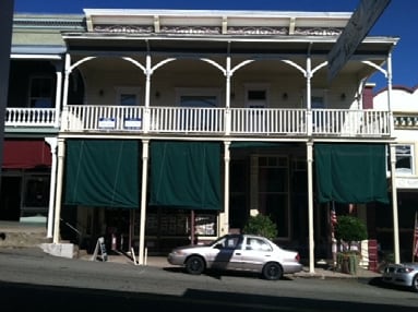
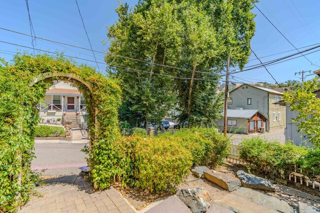
Property Record
50 Main St, Sutter Creek, CA 95685


Property Detail
50 Main St
018-161-007-000
LOT 8 & 9 BLK 12
Commercialnec
Amador
NC
California
B and X Area of moderate flood hazard, usually the area between the limits of the 100-year and 500-year floods.
8,9
2024
0.12 AC
2025
Merced/Central
000401
Other Market Areas
NEARBY LISTINGS FOR SALE OR LEASE
DEMOGRAPHICS near 50 Main St
1 mile
3 mile
5 mile
2025 Total Population
2,756
5,601
10,265
2030 Population
2,776
5,620
10,319
Pop Growth 2025-2030
+ 0.73%
+ 0.34%
+ 0.53%
Average Age
47
47
47
2025 Total Households
1,280
2,550
4,574
HH Growth 2025-2030
+ 0.86%
+ 0.43%
+ 0.61%
Median Household Inc
$71,966
$76,071
$80,306
Avg Household Size
2.10
2.20
2.20
2025 Avg HH Vehicles
2.00
2.00
2.00
Median Home Value
$541,667
$498,083
$512,195
Median Year Built
1972
1979
1979
Nearby Places
Map Layers
Map Styles
 Street
 Aerial
Transit
 Traffic
 Biking
Places
Listings with unknown addresses are not visible on the map
- Restaurants
- Banks
- Shops
- Fitness
- Groceries
PUBLIC TRANSPORTATION
AIRPORT
Stockton Metro
Drive
Walk
Distance
Stockton Metro
73 min
49.8 mi
Freight Ports
Port of Stockton
Drive
Walk
Distance
Port of Stockton
72 min
48.6 mi
SALE & LEASE HISTORY
LISTING DATE
SALE/LEASE

Jul 23, 2024
For Sale
Nearby Properties
Address
Land Use
TOTAL SIZE
Lot Size
Zoning
Address
Land Use
TOTAL SIZE
Lot Size
Zoning
48,945 SF
5.66 AC
M
Address
Land Use
TOTAL SIZE
Lot Size
Zoning
4.75 AC
NC
Address
Land Use
TOTAL SIZE
Lot Size
Zoning
111,658 SF
11.12 AC
C1
Address
Land Use
TOTAL SIZE
Lot Size
Zoning
5.17 AC
M
Address
Land Use
TOTAL SIZE
Lot Size
Zoning
103,794 SF
16.30 AC
PD
Address
Land Use
TOTAL SIZE
Lot Size
Zoning
3,163 SF
26.61 AC
NC
Address
Land Use
TOTAL SIZE
Lot Size
Zoning
Address
Land Use
TOTAL SIZE
Lot Size
Zoning
40,794 SF
3.87 AC
C1
Address
Land Use
TOTAL SIZE
Lot Size
Zoning
40,070 SF
3.74 AC
M
Address
Land Use
TOTAL SIZE
Lot Size
Zoning
39,953 SF
2.03 AC
NC
Address
Land Use
TOTAL SIZE
Lot Size
Zoning
12,670 SF
1.05 AC
C1
Address
Land Use
TOTAL SIZE
Lot Size
Zoning
99,056 SF
10.29 AC
PD-C1
Address
Land Use
TOTAL SIZE
Lot Size
Zoning
3,075 SF
0.75 AC
Address
Land Use
TOTAL SIZE
Lot Size
Zoning
42,900 SF
4.63 AC
C1
Address
Land Use
TOTAL SIZE
Lot Size
Zoning
2,690 SF
0.35 AC
C2
Address
Land Use
TOTAL SIZE
Lot Size
Zoning
Address
Land Use
TOTAL SIZE
Lot Size
Zoning
3.37 AC
MM
Address
Land Use
TOTAL SIZE
Lot Size
Zoning
7,488 SF
2.37 AC
NC
Address
Land Use
TOTAL SIZE
Lot Size
Zoning
44,190 SF
1.16 AC
NC
Address
Land Use
TOTAL SIZE
Lot Size
Zoning
1.18 AC
M
Address
Land Use
TOTAL SIZE
Lot Size
Zoning
2.65 AC
NC
Address
Land Use
TOTAL SIZE
Lot Size
Zoning
5.05 AC
R1A
Address
Land Use
TOTAL SIZE
Lot Size
Zoning
4,000 SF
2.67 AC
Address
Land Use
TOTAL SIZE
Lot Size
Zoning
13,075 SF
2.06 AC
MM
Address
Land Use
TOTAL SIZE
Lot Size
Zoning
2,520 SF
3.42 AC
C1
Address
Land Use
TOTAL SIZE
Lot Size
Zoning
0.27 AC
M
Address
Land Use
TOTAL SIZE
Lot Size
Zoning
7.38 AC
Address
Land Use
TOTAL SIZE
Lot Size
Zoning
12,010 SF
0.81 AC
NC
Address
Land Use
TOTAL SIZE
Lot Size
Zoning
6,480 SF
0.19 AC
NC
Address
Land Use
TOTAL SIZE
Lot Size
Zoning
20.43 AC
M
The World's #1 Commercial Real Estate Marketplace
Connect with us
© 2026 CoStar Group
The information above has been obtained from sources believed reliable. While we do not doubt its accuracy we have not verified it and make no guarantee, warranty or representation about it. It is your responsibility to independently confirm its accuracy and completeness. Any projections, opinions, assumptions, or estimates used are for example only and do not represent the current or future performance of the property. The value of this transaction to you depends on tax and other factors which should be evaluated by your tax, financial, and legal advisors. You and your advisors should conduct a careful, independent investigation of the property to determine to your satisfaction the suitability of the property for your needs.