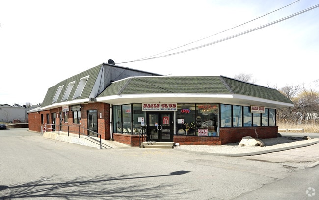
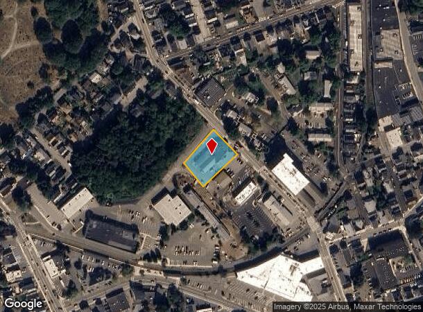
Property Record
50 Maplewood Ave, Gloucester, MA 01930
NEARBY LISTINGS FOR SALE OR LEASE
Property Detail
50 Maplewood Ave
Commercialofficeresidentialmixeduse
Essex
X
Massachusetts
25009C0456H
0.68 AC
2025
Essex/Gloucester
2025
Boston
221600
Boston-Cambridge-Newton, MA-NH
10,880 SF
GLOU-000024-000006
DEMOGRAPHICS near 50 Maplewood Ave
1 Mile
3 Mile
5 Mile
2024 Total Population
12,951
27,195
41,455
2029 Population
12,806
27,334
41,871
Pop Growth 2024-2029
(1.12%)
+ 0.51%
+ 1.00%
Average Age
43
46
47
2024 Total Households
5,874
12,112
18,577
HH Growth 2024-2029
(1.28%)
+ 0.34%
+ 0.87%
Median Household Inc
$64,844
$84,939
$89,383
Avg Household Size
2.20
2.20
2.20
2024 Avg HH Vehicles
1.00
2.00
2.00
Median Home Value
$443,293
$593,750
$642,074
Median Year Built
1947
1949
1951
Nearby Places
Map Layers
Map Styles
 Street
 Aerial
- Restaurants
- Banks
- Shops
- Fitness
- Groceries
PUBLIC TRANSPORTATION
COMMUTER RAIL
Gloucester (Newburyport/Rockport Line - Massachusetts Bay Transportation Authority Commuter Rail (Purple Line))
DRIVE
WALK
Distance
Gloucester (Newburyport/Rockport Line - Massachusetts Bay Transportation Authority Commuter Rail (Purple Line))
1 min
3 min
0.2 mi
West Gloucester (Newburyport/Rockport Line - Massachusetts Bay Transportation Authority Commuter Rail (Purple Line))
DRIVE
WALK
Distance
West Gloucester (Newburyport/Rockport Line - Massachusetts Bay Transportation Authority Commuter Rail (Purple Line))
8 min
3.0 mi
AIRPORT
General Edward Lawrence Logan International
DRIVE
WALK
Distance
General Edward Lawrence Logan International
50 min
34.3 mi
Freight Ports
Port of Boston
DRIVE
WALK
Distance
Port of Boston
1 min
26.3 mi
SALE & LEASE HISTORY
LISTING DATE
SALE/LEASE

Nov 02, 2017
For Sale
Aug 07, 2017
For Sale
Nearby Properties
Address
Land Use
TOTAL SIZE
Lot Size
Zoning
Address
Land Use
TOTAL SIZE
Lot Size
Zoning
187,125 SF
6.22 AC
R-10
Address
Land Use
TOTAL SIZE
Lot Size
Zoning
246,863 SF
18.84 AC
R-20
Address
Land Use
TOTAL SIZE
Lot Size
Zoning
17.56 AC
R-10
Address
Land Use
TOTAL SIZE
Lot Size
Zoning
86,922 SF
7.25 AC
R-20
Address
Land Use
TOTAL SIZE
Lot Size
Zoning
31.17 AC
EB
Address
Land Use
TOTAL SIZE
Lot Size
Zoning
11,513 SF
17.50 AC
R-20
Address
Land Use
TOTAL SIZE
Lot Size
Zoning
60,000 SF
9.91 AC
R-10
Address
Land Use
TOTAL SIZE
Lot Size
Zoning
1,834 SF
23.45 AC
R-10
Address
Land Use
TOTAL SIZE
Lot Size
Zoning
67,972 SF
20.94 AC
R-20
Address
Land Use
TOTAL SIZE
Lot Size
Zoning
19.43 AC
BP
Address
Land Use
TOTAL SIZE
Lot Size
Zoning
85,464 SF
1.85 AC
MI
Address
Land Use
TOTAL SIZE
Lot Size
Zoning
20,109 SF
30.81 AC
RC-40
Address
Land Use
TOTAL SIZE
Lot Size
Zoning
19.26 AC
BP
Address
Land Use
TOTAL SIZE
Lot Size
Zoning
99,838 SF
7.48 AC
BP
Address
Land Use
TOTAL SIZE
Lot Size
Zoning
1,872 SF
54.90 AC
R-10
Address
Land Use
TOTAL SIZE
Lot Size
Zoning
59,161 SF
5.12 AC
EB
Address
Land Use
TOTAL SIZE
Lot Size
Zoning
2,763 SF
150.30 AC
R-20
Address
Land Use
TOTAL SIZE
Lot Size
Zoning
8.42 AC
EB
Address
Land Use
TOTAL SIZE
Lot Size
Zoning
14,493 SF
3.98 AC
R-5
Address
Land Use
TOTAL SIZE
Lot Size
Zoning
66,657 SF
0.77 AC
R-5
Address
Land Use
TOTAL SIZE
Lot Size
Zoning
47,350 SF
3.52 AC
BP
Address
Land Use
TOTAL SIZE
Lot Size
Zoning
2.60 AC
MI
Address
Land Use
TOTAL SIZE
Lot Size
Zoning
158,752 SF
10.38 AC
BP
Address
Land Use
TOTAL SIZE
Lot Size
Zoning
1.49 AC
R-5
Address
Land Use
TOTAL SIZE
Lot Size
Zoning
14,042 SF
12 AC
R-20
Address
Land Use
TOTAL SIZE
Lot Size
Zoning
14,914 SF
2.25 AC
RC-40
Address
Land Use
TOTAL SIZE
Lot Size
Zoning
71,950 SF
1 AC
CCD
Address
Land Use
TOTAL SIZE
Lot Size
Zoning
65,108 SF
7.37 AC
EB
Address
Land Use
TOTAL SIZE
Lot Size
Zoning
138,050 SF
2.63 AC
MI
Address
Land Use
TOTAL SIZE
Lot Size
Zoning
56,266 SF
9.59 AC
BP
The World's #1 Commercial Real Estate Marketplace
Connect with us
© 2026 CoStar Group
The information above has been obtained from sources believed reliable. While we do not doubt its accuracy we have not verified it and make no guarantee, warranty or representation about it. It is your responsibility to independently confirm its accuracy and completeness. Any projections, opinions, assumptions, or estimates used are for example only and do not represent the current or future performance of the property. The value of this transaction to you depends on tax and other factors which should be evaluated by your tax, financial, and legal advisors. You and your advisors should conduct a careful, independent investigation of the property to determine to your satisfaction the suitability of the property for your needs.