Property Record
50 Minuteman Rd, Andover, MA 01810
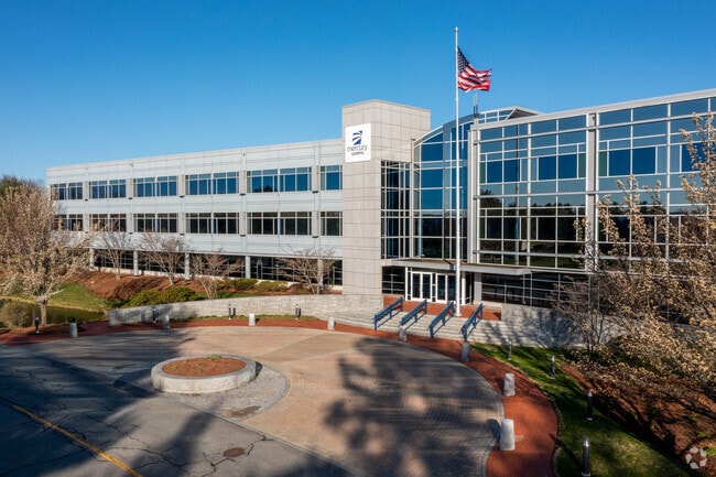

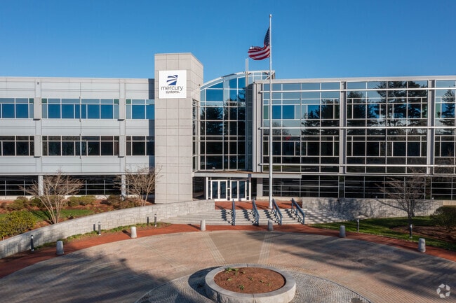

Property Detail
50 Minuteman Rd
ANDO-000188-000005-C000000
Essex
Officebuilding
Massachusetts
ID2
c
B and X Area of moderate flood hazard, usually the area between the limits of the 100-year and 500-year floods.
13.73 AC
2025
Lawrence/Andover
2025
Boston
254402
Boston-Cambridge-Newton, MA-NH
162,978 SF
NEARBY LISTINGS FOR SALE OR LEASE
DEMOGRAPHICS near 50 Minuteman Rd
1 mile
3 mile
5 mile
2025 Total Population
2,539
71,638
204,418
2030 Population
2,626
72,252
207,482
Pop Growth 2025-2030
+ 3.43%
+ 0.86%
+ 1.50%
Average Age
40
39
39
2025 Total Households
982
24,769
71,965
HH Growth 2025-2030
+ 3.26%
+ 0.94%
+ 1.65%
Median Household Inc
$148,345
$77,554
$87,864
Avg Household Size
2.60
2.80
2.70
2025 Avg HH Vehicles
2.00
2.00
2.00
Median Home Value
$788,157
$528,309
$559,942
Median Year Built
1991
1960
1962
Nearby Places
Map Layers
Map Styles
 Street
 Aerial
Layers
 Traffic
 Biking
Places
Listings with unknown addresses are not visible on the map
- Restaurants
- Banks
- Shops
- Fitness
- Groceries
PUBLIC TRANSPORTATION
COMMUTER RAIL
Lawrence (Haverhill Line - Massachusetts Bay Transportation Authority Commuter Rail (Purple Line))
Drive
Walk
Distance
Lawrence (Haverhill Line - Massachusetts Bay Transportation Authority Commuter Rail (Purple Line))
10 min
4.3 mi
Andover (Haverhill Line - Massachusetts Bay Transportation Authority Commuter Rail (Purple Line))
Drive
Walk
Distance
Andover (Haverhill Line - Massachusetts Bay Transportation Authority Commuter Rail (Purple Line))
13 min
5.6 mi
AIRPORT
Manchester Boston Regional
Drive
Walk
Distance
Manchester Boston Regional
42 min
26.6 mi
General Edward Lawrence Logan International
Drive
Walk
Distance
General Edward Lawrence Logan International
40 min
28.2 mi
Portsmouth International at Pease
Drive
Walk
Distance
Portsmouth International at Pease
58 min
41.8 mi
Nearby Properties
Address
Land Use
TOTAL SIZE
Lot Size
Zoning
Address
Land Use
TOTAL SIZE
Lot Size
Zoning
10.40 AC
ID
Address
Land Use
TOTAL SIZE
Lot Size
Zoning
61.83 AC
ID2
Address
Land Use
TOTAL SIZE
Lot Size
Zoning
24 AC
ID
Address
Land Use
TOTAL SIZE
Lot Size
Zoning
382,817 SF
25.86 AC
ID2
Address
Land Use
TOTAL SIZE
Lot Size
Zoning
22.55 AC
IA
Address
Land Use
TOTAL SIZE
Lot Size
Zoning
237,705 SF
33.49 AC
ID
Address
Land Use
TOTAL SIZE
Lot Size
Zoning
48.33 AC
ID
Address
Land Use
TOTAL SIZE
Lot Size
Zoning
152,040 SF
9.10 AC
SRC
Address
Land Use
TOTAL SIZE
Lot Size
Zoning
210,192 SF
15.06 AC
CN
Address
Land Use
TOTAL SIZE
Lot Size
Zoning
196,152 SF
20.20 AC
ID2
Address
Land Use
TOTAL SIZE
Lot Size
Zoning
43.36 AC
ID2
Address
Land Use
TOTAL SIZE
Lot Size
Zoning
Address
Land Use
TOTAL SIZE
Lot Size
Zoning
322,858 SF
15.97 AC
ID
Address
Land Use
TOTAL SIZE
Lot Size
Zoning
6.84 AC
Address
Land Use
TOTAL SIZE
Lot Size
Zoning
2,552 SF
14.23 AC
Address
Land Use
TOTAL SIZE
Lot Size
Zoning
150,292 SF
22.77 AC
ID2
Address
Land Use
TOTAL SIZE
Lot Size
Zoning
105,949 SF
28.24 AC
ID2
Address
Land Use
TOTAL SIZE
Lot Size
Zoning
3,462 SF
8.14 AC
Address
Land Use
TOTAL SIZE
Lot Size
Zoning
2.52 AC
Address
Land Use
TOTAL SIZE
Lot Size
Zoning
5.43 AC
ID
Address
Land Use
TOTAL SIZE
Lot Size
Zoning
234,000 SF
17.55 AC
IL
Address
Land Use
TOTAL SIZE
Lot Size
Zoning
26.60 AC
Address
Land Use
TOTAL SIZE
Lot Size
Zoning
127,448 SF
13.14 AC
ID
Address
Land Use
TOTAL SIZE
Lot Size
Zoning
124,760 SF
13.51 AC
ID
Address
Land Use
TOTAL SIZE
Lot Size
Zoning
10,614 SF
6.67 AC
Address
Land Use
TOTAL SIZE
Lot Size
Zoning
9.10 AC
MB
Address
Land Use
TOTAL SIZE
Lot Size
Zoning
2.15 AC
Address
Land Use
TOTAL SIZE
Lot Size
Zoning
1.65 AC
Address
Land Use
TOTAL SIZE
Lot Size
Zoning
37.05 AC
SRC
The World's #1 Commercial Real Estate Marketplace
Connect with us
© 2026 CoStar Group
The information above has been obtained from sources believed reliable. While we do not doubt its accuracy we have not verified it and make no guarantee, warranty or representation about it. It is your responsibility to independently confirm its accuracy and completeness. Any projections, opinions, assumptions, or estimates used are for example only and do not represent the current or future performance of the property. The value of this transaction to you depends on tax and other factors which should be evaluated by your tax, financial, and legal advisors. You and your advisors should conduct a careful, independent investigation of the property to determine to your satisfaction the suitability of the property for your needs.