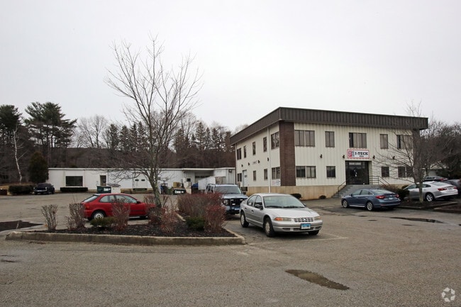
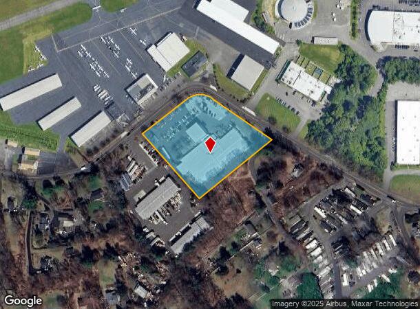
Property Record
52 Miry Brook Rd, Danbury, CT 06810
This Property Is For Sale
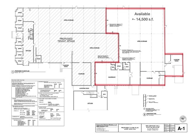
Current Lease Availabilities
NEARBY LISTINGS FOR SALE OR LEASE
Property Detail
52 Miry Brook Rd
DANB-000019F-000000-000049
Fairfield
Industrialgeneral
Connecticut
X
49
09001C0226F
2.91 AC
2025
Danbury
2025
Westchester/So Connecticut
210502
Bridgeport-Stamford-Norwalk, CT
DEMOGRAPHICS near 52 Miry Brook Rd
1 Mile
3 Mile
5 Mile
2024 Total Population
1,310
47,349
101,566
2029 Population
1,297
47,023
101,019
Pop Growth 2024-2029
(0.99%)
(0.69%)
(0.54%)
Average Age
44
39
40
2024 Total Households
476
17,240
36,844
HH Growth 2024-2029
(1.05%)
(0.75%)
(0.63%)
Median Household Inc
$74,062
$73,597
$84,630
Avg Household Size
2.50
2.60
2.60
2024 Avg HH Vehicles
2.00
2.00
2.00
Median Home Value
$392,822
$365,672
$383,216
Median Year Built
1974
1970
1972
Nearby Places
Map Layers
Map Styles
 Street
 Aerial
- Restaurants
- Banks
- Shops
- Fitness
- Groceries
PUBLIC TRANSPORTATION
COMMUTER RAIL
Danbury Station (New Haven Line - Metro-North Commuter Railroad Company (Metro-North))
DRIVE
WALK
Distance
Danbury Station (New Haven Line - Metro-North Commuter Railroad Company (Metro-North))
10 min
3.7 mi
Redding Station (New Haven Line - Metro-North Commuter Railroad Company (Metro-North))
DRIVE
WALK
Distance
Redding Station (New Haven Line - Metro-North Commuter Railroad Company (Metro-North))
13 min
5.3 mi
AIRPORT
Westchester County
DRIVE
WALK
Distance
Westchester County
45 min
34.1 mi
Tweed/New Haven
DRIVE
WALK
Distance
Tweed/New Haven
64 min
42.9 mi
New York Stewart International
DRIVE
WALK
Distance
New York Stewart International
61 min
45.1 mi
Freight Ports
Port of New Haven
DRIVE
WALK
Distance
Port of New Haven
59 min
40.0 mi
Nearby Properties
Address
Land Use
TOTAL SIZE
Lot Size
Zoning
Address
Land Use
TOTAL SIZE
Lot Size
Zoning
69.58 AC
CG20
Address
Land Use
TOTAL SIZE
Lot Size
Zoning
505.03 AC
PND
Address
Land Use
TOTAL SIZE
Lot Size
Zoning
9.04 AC
CCBD
Address
Land Use
TOTAL SIZE
Lot Size
Zoning
253,696 SF
83.75 AC
CDD
Address
Land Use
TOTAL SIZE
Lot Size
Zoning
56.59 AC
IL40
Address
Land Use
TOTAL SIZE
Lot Size
Zoning
135.19 AC
IL40
Address
Land Use
TOTAL SIZE
Lot Size
Zoning
18.63 AC
CG20
Address
Land Use
TOTAL SIZE
Lot Size
Zoning
32.98 AC
PND
Address
Land Use
TOTAL SIZE
Lot Size
Zoning
273,127 SF
10.33 AC
RA-40
Address
Land Use
TOTAL SIZE
Lot Size
Zoning
10.51 AC
RMF-4
Address
Land Use
TOTAL SIZE
Lot Size
Zoning
31 AC
RMF4
Address
Land Use
TOTAL SIZE
Lot Size
Zoning
165,840 SF
9.49 AC
CG20
Address
Land Use
TOTAL SIZE
Lot Size
Zoning
478,816 SF
39.59 AC
IL40
Address
Land Use
TOTAL SIZE
Lot Size
Zoning
137,884 SF
16.96 AC
1L40
Address
Land Use
TOTAL SIZE
Lot Size
Zoning
196,544 SF
PND
Address
Land Use
TOTAL SIZE
Lot Size
Zoning
196,513 SF
PND
Address
Land Use
TOTAL SIZE
Lot Size
Zoning
10.44 AC
CA80
Address
Land Use
TOTAL SIZE
Lot Size
Zoning
158,981 SF
12.79 AC
RA20
Address
Land Use
TOTAL SIZE
Lot Size
Zoning
45.78 AC
RM12
Address
Land Use
TOTAL SIZE
Lot Size
Zoning
47,564 SF
4.45 AC
CCBD
Address
Land Use
TOTAL SIZE
Lot Size
Zoning
10 AC
CG-20
Address
Land Use
TOTAL SIZE
Lot Size
Zoning
17.24 AC
IL-40
Address
Land Use
TOTAL SIZE
Lot Size
Zoning
198,560 SF
3.30 AC
CLCB
Address
Land Use
TOTAL SIZE
Lot Size
Zoning
10.51 AC
IL40
Address
Land Use
TOTAL SIZE
Lot Size
Zoning
133,936 SF
5.61 AC
IL40
Address
Land Use
TOTAL SIZE
Lot Size
Zoning
7,732 SF
42.55 AC
RMF-4
Address
Land Use
TOTAL SIZE
Lot Size
Zoning
13.39 AC
RMF-6
Address
Land Use
TOTAL SIZE
Lot Size
Zoning
175,406 SF
12.23 AC
CG20
Address
Land Use
TOTAL SIZE
Lot Size
Zoning
1,639 SF
30 AC
RA40
Address
Land Use
TOTAL SIZE
Lot Size
Zoning
63,436 SF
7.03 AC
RA40
The World's #1 Commercial Real Estate Marketplace
Connect with us
© 2026 CoStar Group
The information above has been obtained from sources believed reliable. While we do not doubt its accuracy we have not verified it and make no guarantee, warranty or representation about it. It is your responsibility to independently confirm its accuracy and completeness. Any projections, opinions, assumptions, or estimates used are for example only and do not represent the current or future performance of the property. The value of this transaction to you depends on tax and other factors which should be evaluated by your tax, financial, and legal advisors. You and your advisors should conduct a careful, independent investigation of the property to determine to your satisfaction the suitability of the property for your needs.