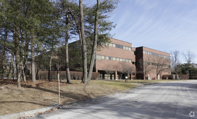
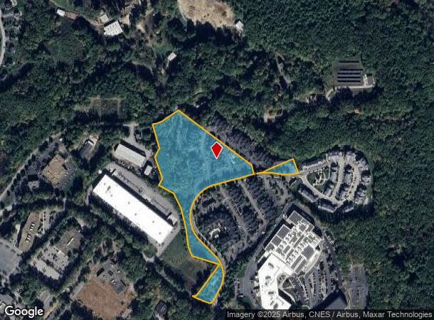
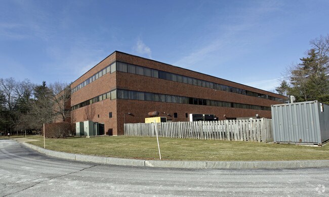
Property Record
50 Nagog Park, Acton, MA 01720

NEARBY LISTINGS FOR SALE OR LEASE
Property Detail
50 Nagog Park
Apartment
Middlesex
X
Massachusetts
25017C0243F
9.96 AC
2025
Concord/Maynard
2025
Boston
363106
Boston-Cambridge-Newton, MA-NH
119,000 SF
ACTO-000004B-000004
DEMOGRAPHICS near 50 Nagog Park
1 Mile
3 Mile
5 Mile
2024 Total Population
3,858
21,773
61,775
2029 Population
3,873
21,883
61,471
Pop Growth 2024-2029
+ 0.39%
+ 0.51%
(0.49%)
Average Age
41
42
42
2024 Total Households
1,479
8,141
22,807
HH Growth 2024-2029
+ 0.34%
+ 0.43%
(0.55%)
Median Household Inc
$122,684
$138,516
$153,502
Avg Household Size
2.50
2.60
2.70
2024 Avg HH Vehicles
2.00
2.00
2.00
Median Home Value
$643,503
$710,323
$703,900
Median Year Built
1995
1985
1978
Nearby Places
Map Layers
Map Styles
 Street
 Aerial
- Restaurants
- Banks
- Shops
- Fitness
- Groceries
PUBLIC TRANSPORTATION
COMMUTER RAIL
Littleton/Route 495 (Fitchburg/South Acton Line - Massachusetts Bay Transportation Authority Commuter Rail (Purple Line))
DRIVE
WALK
Distance
Littleton/Route 495 (Fitchburg/South Acton Line - Massachusetts Bay Transportation Authority Commuter Rail (Purple Line))
14 min
6.0 mi
South Acton (Fitchburg/South Acton Line - Massachusetts Bay Transportation Authority Commuter Rail (Purple Line))
DRIVE
WALK
Distance
South Acton (Fitchburg/South Acton Line - Massachusetts Bay Transportation Authority Commuter Rail (Purple Line))
16 min
6.3 mi
AIRPORT
General Edward Lawrence Logan International
DRIVE
WALK
Distance
General Edward Lawrence Logan International
50 min
29.4 mi
Manchester Boston Regional
DRIVE
WALK
Distance
Manchester Boston Regional
58 min
35.4 mi
Worcester Regional
DRIVE
WALK
Distance
Worcester Regional
55 min
37.7 mi
Freight Ports
Port of Boston
DRIVE
WALK
Distance
Port of Boston
49 min
29.4 mi
SALE & LEASE HISTORY
LISTING DATE
SALE/LEASE

Oct 17, 2016
For Lease
Jan 15, 2020
For Lease
Dec 08, 2017
For Sale
Nearby Properties
Address
Land Use
TOTAL SIZE
Lot Size
Zoning
Address
Land Use
TOTAL SIZE
Lot Size
Zoning
310,328 SF
22.24 AC
IH
Address
Land Use
TOTAL SIZE
Lot Size
Zoning
236,297 SF
17.62 AC
CH
Address
Land Use
TOTAL SIZE
Lot Size
Zoning
8.39 AC
OP1
Address
Land Use
TOTAL SIZE
Lot Size
Zoning
220,257 SF
24.17 AC
CH
Address
Land Use
TOTAL SIZE
Lot Size
Zoning
39.84 AC
B
Address
Land Use
TOTAL SIZE
Lot Size
Zoning
7.32 AC
R
Address
Land Use
TOTAL SIZE
Lot Size
Zoning
161,850 SF
18.41 AC
CH
Address
Land Use
TOTAL SIZE
Lot Size
Zoning
14.47 AC
R108
Address
Land Use
TOTAL SIZE
Lot Size
Zoning
291,926 SF
31.78 AC
IH
Address
Land Use
TOTAL SIZE
Lot Size
Zoning
79,254 SF
18.14 AC
RA
Address
Land Use
TOTAL SIZE
Lot Size
Zoning
155,922 SF
14.61 AC
CH
Address
Land Use
TOTAL SIZE
Lot Size
Zoning
396,023 SF
23.53 AC
OP1
Address
Land Use
TOTAL SIZE
Lot Size
Zoning
171,494 SF
15.68 AC
CH
Address
Land Use
TOTAL SIZE
Lot Size
Zoning
39,250 SF
0.39 AC
R2
Address
Land Use
TOTAL SIZE
Lot Size
Zoning
87,430 SF
9.30 AC
CH
Address
Land Use
TOTAL SIZE
Lot Size
Zoning
130,524 SF
19.74 AC
IH
Address
Land Use
TOTAL SIZE
Lot Size
Zoning
66,447 SF
11.59 AC
B
Address
Land Use
TOTAL SIZE
Lot Size
Zoning
175,718 SF
20.12 AC
IH
Address
Land Use
TOTAL SIZE
Lot Size
Zoning
38,552 SF
5.34 AC
LB
Address
Land Use
TOTAL SIZE
Lot Size
Zoning
57,700 SF
8.27 AC
CH
Address
Land Use
TOTAL SIZE
Lot Size
Zoning
78,564 SF
3.43 AC
LB
Address
Land Use
TOTAL SIZE
Lot Size
Zoning
119,000 SF
11.19 AC
OP1
Address
Land Use
TOTAL SIZE
Lot Size
Zoning
78,722 SF
7.54 AC
LB
Address
Land Use
TOTAL SIZE
Lot Size
Zoning
3.85 AC
RA
Address
Land Use
TOTAL SIZE
Lot Size
Zoning
60,850 SF
31.75 AC
R
Address
Land Use
TOTAL SIZE
Lot Size
Zoning
80,974 SF
14.36 AC
CH
Address
Land Use
TOTAL SIZE
Lot Size
Zoning
44,586 SF
8.28 AC
CH
Address
Land Use
TOTAL SIZE
Lot Size
Zoning
14,856 SF
136.91 AC
CH
Address
Land Use
TOTAL SIZE
Lot Size
Zoning
66,515 SF
23.98 AC
SM
The World's #1 Commercial Real Estate Marketplace
Connect with us
© 2026 CoStar Group
The information above has been obtained from sources believed reliable. While we do not doubt its accuracy we have not verified it and make no guarantee, warranty or representation about it. It is your responsibility to independently confirm its accuracy and completeness. Any projections, opinions, assumptions, or estimates used are for example only and do not represent the current or future performance of the property. The value of this transaction to you depends on tax and other factors which should be evaluated by your tax, financial, and legal advisors. You and your advisors should conduct a careful, independent investigation of the property to determine to your satisfaction the suitability of the property for your needs.