Property Record
50 Notch Ln, Reeds Spring, MO 65737

Save to a Folder
{{folder.Name}}
{{folder.ListingIds.length}} Properties
{{folder.ListingIds.length}} Property
Create a New Folder
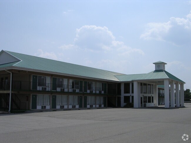
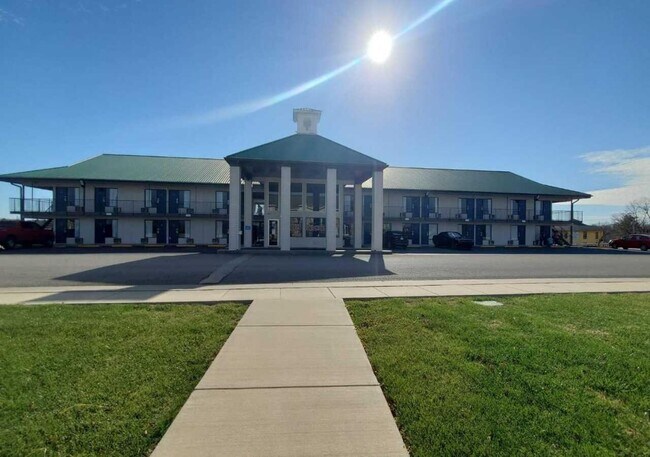
Property Detail
50 Notch Ln
Motel
BEG AT A PT ON ELY R/W HWY 76 SD PT BEING S 1750.61 FT & W 857.13 FT FROM NE COR NW, E 413.83 FT, N TO SLY R/W OF A RD, WLY ALONG R/W TO ELY R/W HWY 76, SLY ALONG R/W TO POB EXCEPT OUT A PART OF SE 1/4 OF THE NW 1/4 BEG @ NE COR SW 25 NW 60 SE 60 SW
C-2
STONE
B and X Area of moderate flood hazard, usually the area between the limits of the 100-year and 500-year floods.
Missouri
2024
3.54 AC
2025
Branson
090605
Other Market Areas
11,892 SF
12-4.0-20-000-000-003.028
NEARBY LISTINGS FOR SALE OR LEASE
-
-
View all Reeds Spring listings for sale on LoopNet.com
DEMOGRAPHICS near 50 Notch Ln
1 mile
3 mile
5 mile
2025 Total Population
482
3,434
12,780
2030 Population
531
3,671
13,156
Pop Growth 2025-2030
+ 10.17%
+ 6.90%
+ 2.94%
Average Age
52
50
45
2025 Total Households
226
1,532
5,559
HH Growth 2025-2030
+ 10.18%
+ 7.05%
+ 3.00%
Median Household Inc
$74,084
$68,020
$61,902
Avg Household Size
2.10
2.20
2.20
2025 Avg HH Vehicles
2.00
2.00
2.00
Median Home Value
$306,250
$283,713
$285,964
Median Year Built
2003
1999
1998
Nearby Places
Map Layers
Map Styles
 Street
 Aerial
Layers
 Traffic
 Biking
Places
Listings with unknown addresses are not visible on the map
- Restaurants
- Banks
- Shops
- Fitness
- Groceries
SALE & LEASE HISTORY
LISTING DATE
SALE/LEASE

Sep 17, 2018
For Sale
Mar 07, 2025
For Sale
Jun 24, 2019
For Sale
Nearby Properties
Address
Land Use
TOTAL SIZE
Lot Size
Zoning
Address
Land Use
TOTAL SIZE
Lot Size
Zoning
20,182 SF
160.11 AC
C-2
Address
Land Use
TOTAL SIZE
Lot Size
Zoning
153,535 SF
18.72 AC
NA
Address
Land Use
TOTAL SIZE
Lot Size
Zoning
26,445 SF
104.70 AC
A-1
Address
Land Use
TOTAL SIZE
Lot Size
Zoning
46,896 SF
135.58 AC
Address
Land Use
TOTAL SIZE
Lot Size
Zoning
19,186 SF
172.04 AC
C-2
Address
Land Use
TOTAL SIZE
Lot Size
Zoning
6,000 SF
11.93 AC
NA
Address
Land Use
TOTAL SIZE
Lot Size
Zoning
58,080 SF
6.81 AC
C-2
Address
Land Use
TOTAL SIZE
Lot Size
Zoning
44,979 SF
12.80 AC
NA
Address
Land Use
TOTAL SIZE
Lot Size
Zoning
11,648 SF
6.65 AC
NA
Address
Land Use
TOTAL SIZE
Lot Size
Zoning
7,088 SF
1.98 AC
C-2
Address
Land Use
TOTAL SIZE
Lot Size
Zoning
14,748 SF
1.60 AC
NA
Address
Land Use
TOTAL SIZE
Lot Size
Zoning
77,252 SF
36.08 AC
A-1
Address
Land Use
TOTAL SIZE
Lot Size
Zoning
15,000 SF
2.32 AC
NA
Address
Land Use
TOTAL SIZE
Lot Size
Zoning
23,640 SF
29.64 AC
NA
Address
Land Use
TOTAL SIZE
Lot Size
Zoning
92,520 SF
Address
Land Use
TOTAL SIZE
Lot Size
Zoning
6,803 SF
1.03 AC
A-1
Address
Land Use
TOTAL SIZE
Lot Size
Zoning
25,052 SF
3.98 AC
NA
Address
Land Use
TOTAL SIZE
Lot Size
Zoning
11,860 SF
5.40 AC
C-2
Address
Land Use
TOTAL SIZE
Lot Size
Zoning
36,558 SF
7.60 AC
NA
Address
Land Use
TOTAL SIZE
Lot Size
Zoning
8,100 SF
1.13 AC
Address
Land Use
TOTAL SIZE
Lot Size
Zoning
8,915 SF
3.27 AC
C-2
Address
Land Use
TOTAL SIZE
Lot Size
Zoning
400,000 SF
0.04 AC
Address
Land Use
TOTAL SIZE
Lot Size
Zoning
6,000 SF
0.87 AC
Address
Land Use
TOTAL SIZE
Lot Size
Zoning
46,225 SF
Address
Land Use
TOTAL SIZE
Lot Size
Zoning
3,520 SF
1.30 AC
Address
Land Use
TOTAL SIZE
Lot Size
Zoning
4,335 SF
0.90 AC
RR-1
Address
Land Use
TOTAL SIZE
Lot Size
Zoning
3,702 SF
36.98 AC
C-2
Address
Land Use
TOTAL SIZE
Lot Size
Zoning
13,979 SF
68 AC
C-2
The World's #1 Commercial Real Estate Marketplace
Connect with us
© 2026 CoStar Group
The information above has been obtained from sources believed reliable. While we do not doubt its accuracy we have not verified it and make no guarantee, warranty or representation about it. It is your responsibility to independently confirm its accuracy and completeness. Any projections, opinions, assumptions, or estimates used are for example only and do not represent the current or future performance of the property. The value of this transaction to you depends on tax and other factors which should be evaluated by your tax, financial, and legal advisors. You and your advisors should conduct a careful, independent investigation of the property to determine to your satisfaction the suitability of the property for your needs.