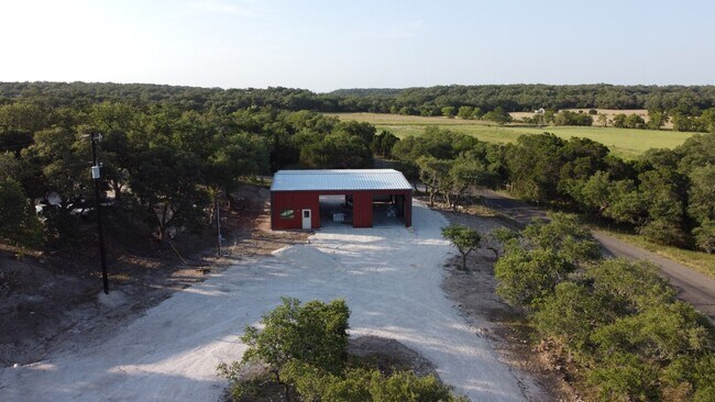
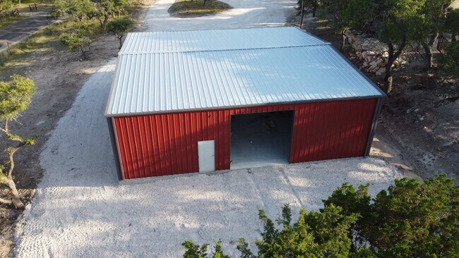
Property Record
50 Rust Ln, Boerne, TX 78006

NEARBY LISTINGS FOR SALE OR LEASE
Property Detail
50 Rust Ln
13420
Survey 473 P Gauno
Commercialbuilding
A10388 - SURVEY 734 A PFEIFFER HUD# NTA1868572, (IMPROVEMENT ONLY) (IMPROVEMENT ONLY)
X
Kendall
48259C0425F
Texas
2024
0.88 AC
2025
Kendall County
970403
San Antonio
2,882 SF
San Antonio-New Braunfels, TX
DEMOGRAPHICS near 50 Rust Ln
1 Mile
3 Mile
5 Mile
2024 Total Population
57
2,650
23,922
2029 Population
69
3,302
30,052
Pop Growth 2024-2029
+ 21.05%
+ 24.60%
+ 25.62%
Average Age
46
44
41
2024 Total Households
22
941
8,562
HH Growth 2024-2029
+ 22.73%
+ 24.97%
+ 26.03%
Median Household Inc
$124,999
$133,430
$114,451
Avg Household Size
2.40
2.80
2.70
2024 Avg HH Vehicles
3.00
3.00
2.00
Median Home Value
$478,571
$539,883
$474,426
Median Year Built
1989
2005
2004
Nearby Places
Map Layers
Map Styles
 Street
 Aerial
- Restaurants
- Banks
- Shops
- Fitness
- Groceries
PUBLIC TRANSPORTATION
AIRPORT
San Antonio International
DRIVE
WALK
Distance
San Antonio International
53 min
35.0 mi
Freight Ports
Calhoun Port
DRIVE
WALK
Distance
Calhoun Port
231 min
183.4 mi
SALE & LEASE HISTORY
LISTING DATE
SALE/LEASE

Jul 21, 2017
For Lease
Nearby Properties
Address
Land Use
TOTAL SIZE
Lot Size
Zoning
Address
Land Use
TOTAL SIZE
Lot Size
Zoning
166,650 SF
14.62 AC
Address
Land Use
TOTAL SIZE
Lot Size
Zoning
46,506 SF
11.40 AC
Address
Land Use
TOTAL SIZE
Lot Size
Zoning
10,800 SF
13.12 AC
Address
Land Use
TOTAL SIZE
Lot Size
Zoning
16,700 SF
1.71 AC
Address
Land Use
TOTAL SIZE
Lot Size
Zoning
8,932 SF
1.15 AC
Address
Land Use
TOTAL SIZE
Lot Size
Zoning
10,500 SF
1.23 AC
Address
Land Use
TOTAL SIZE
Lot Size
Zoning
4,562 SF
11.14 AC
Address
Land Use
TOTAL SIZE
Lot Size
Zoning
32.21 AC
Address
Land Use
TOTAL SIZE
Lot Size
Zoning
8,952 SF
6.49 AC
Address
Land Use
TOTAL SIZE
Lot Size
Zoning
31,504 SF
2.10 AC
Address
Land Use
TOTAL SIZE
Lot Size
Zoning
13,857 SF
2.49 AC
Address
Land Use
TOTAL SIZE
Lot Size
Zoning
28,705 SF
1.51 AC
Address
Land Use
TOTAL SIZE
Lot Size
Zoning
4,562 SF
11.14 AC
Address
Land Use
TOTAL SIZE
Lot Size
Zoning
9,076 SF
2.94 AC
Address
Land Use
TOTAL SIZE
Lot Size
Zoning
9,589 SF
3.99 AC
Address
Land Use
TOTAL SIZE
Lot Size
Zoning
9,589 SF
3.99 AC
Address
Land Use
TOTAL SIZE
Lot Size
Zoning
10,355 SF
25.41 AC
Address
Land Use
TOTAL SIZE
Lot Size
Zoning
5,508 SF
1.53 AC
Address
Land Use
TOTAL SIZE
Lot Size
Zoning
1.67 AC
Address
Land Use
TOTAL SIZE
Lot Size
Zoning
2,752 SF
6.50 AC
Address
Land Use
TOTAL SIZE
Lot Size
Zoning
Address
Land Use
TOTAL SIZE
Lot Size
Zoning
16,000 SF
1.11 AC
Address
Land Use
TOTAL SIZE
Lot Size
Zoning
7,400 SF
3.82 AC
Address
Land Use
TOTAL SIZE
Lot Size
Zoning
6,429 SF
5.84 AC
Address
Land Use
TOTAL SIZE
Lot Size
Zoning
12,056 SF
1.03 AC
Address
Land Use
TOTAL SIZE
Lot Size
Zoning
15,500 SF
1.03 AC
Address
Land Use
TOTAL SIZE
Lot Size
Zoning
1,925 SF
6.31 AC
Address
Land Use
TOTAL SIZE
Lot Size
Zoning
4,654 SF
9.11 AC
Address
Land Use
TOTAL SIZE
Lot Size
Zoning
9,372 SF
1.17 AC
Address
Land Use
TOTAL SIZE
Lot Size
Zoning
5,527 SF
43.23 AC
The World's #1 Commercial Real Estate Marketplace
Connect with us
© 2026 CoStar Group
The information above has been obtained from sources believed reliable. While we do not doubt its accuracy we have not verified it and make no guarantee, warranty or representation about it. It is your responsibility to independently confirm its accuracy and completeness. Any projections, opinions, assumptions, or estimates used are for example only and do not represent the current or future performance of the property. The value of this transaction to you depends on tax and other factors which should be evaluated by your tax, financial, and legal advisors. You and your advisors should conduct a careful, independent investigation of the property to determine to your satisfaction the suitability of the property for your needs.