Property Record
50 S Farmland Rd, Garden City, KS 67846
NEARBY LISTINGS FOR SALE OR LEASE
-
-
View all Garden City listings for sale on LoopNet.com
Property Detail
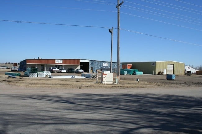
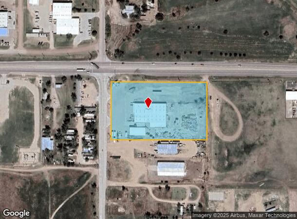
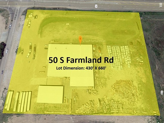
50 S Farmland Rd
Other Market Areas
Southwest Pallet Addition
Garden City, KS
SOUTHWEST PALLET ADDITION, S23, T24, R32W, BLOCK 01, LOT 01 - 02, ACRES 5.16
276-23-0-00-01-005.00-0
Finney
Warehouse
Kansas
2025
1-2
2025
5.16 AC
960501
Kansas Area
24,321 SF
DEMOGRAPHICS near 50 S Farmland Rd
1 Mile
3 Mile
5 Mile
2024 Total Population
2,445
12,750
31,504
2029 Population
2,378
12,373
30,544
Pop Growth 2024-2029
(2.74%)
(2.96%)
(3.05%)
Average Age
31
35
35
2024 Total Households
708
4,235
10,785
HH Growth 2024-2029
(2.68%)
(2.98%)
(3.07%)
Median Household Inc
$47,812
$58,571
$63,569
Avg Household Size
3.30
2.90
2.80
2024 Avg HH Vehicles
3.00
2.00
2.00
Median Home Value
$66,955
$155,198
$163,870
Median Year Built
1979
1980
1976
Nearby Places
- Restaurants
- Banks
- Shops
- Fitness
- Groceries
PUBLIC TRANSPORTATION
COMMUTER RAIL
Garden City Amtrak Station (Southwest Chief - Amtrak)
DRIVE
WALK
Distance
Garden City Amtrak Station (Southwest Chief - Amtrak)
5 min
3.6 mi
Freight Ports
Tulsa Port Of Catoosa
DRIVE
WALK
Distance
Tulsa Port Of Catoosa
446 min
391.4 mi
SALE & LEASE HISTORY
LISTING DATE
SALE/LEASE

May 21, 2019
For Sale
Nearby Properties
Address
Land Use
TOTAL SIZE
Lot Size
Zoning
Address
Land Use
TOTAL SIZE
Lot Size
Zoning
485,653 SF
107.22 AC
Address
Land Use
TOTAL SIZE
Lot Size
Zoning
21,733 SF
60.54 AC
PF
Address
Land Use
TOTAL SIZE
Lot Size
Zoning
6,300 SF
55.93 AC
Address
Land Use
TOTAL SIZE
Lot Size
Zoning
2,720 SF
13.43 AC
A
Address
Land Use
TOTAL SIZE
Lot Size
Zoning
38,151 SF
9.04 AC
R3
Address
Land Use
TOTAL SIZE
Lot Size
Zoning
69,088 SF
13.95 AC
A
Address
Land Use
TOTAL SIZE
Lot Size
Zoning
21,875 SF
17.05 AC
I3
Address
Land Use
TOTAL SIZE
Lot Size
Zoning
28,917 SF
3.99 AC
A
Address
Land Use
TOTAL SIZE
Lot Size
Zoning
64,277 SF
4.97 AC
R2
Address
Land Use
TOTAL SIZE
Lot Size
Zoning
60,280 SF
15.25 AC
A
Address
Land Use
TOTAL SIZE
Lot Size
Zoning
182,192 SF
24.54 AC
Address
Land Use
TOTAL SIZE
Lot Size
Zoning
121,301 SF
15.46 AC
A
Address
Land Use
TOTAL SIZE
Lot Size
Zoning
21,794 SF
3.12 AC
Address
Land Use
TOTAL SIZE
Lot Size
Zoning
46,619 SF
3.46 AC
R1
Address
Land Use
TOTAL SIZE
Lot Size
Zoning
17,176 SF
1.93 AC
C2
Address
Land Use
TOTAL SIZE
Lot Size
Zoning
4,545 SF
13.83 AC
I2
Address
Land Use
TOTAL SIZE
Lot Size
Zoning
10,200 SF
83.93 AC
PF
Address
Land Use
TOTAL SIZE
Lot Size
Zoning
173,810 SF
18.33 AC
Address
Land Use
TOTAL SIZE
Lot Size
Zoning
204,578 SF
28.50 AC
GC
Address
Land Use
TOTAL SIZE
Lot Size
Zoning
10,146 SF
7.58 AC
Address
Land Use
TOTAL SIZE
Lot Size
Zoning
2,440 SF
3.32 AC
R1
Address
Land Use
TOTAL SIZE
Lot Size
Zoning
17,322 SF
1.72 AC
R4
Address
Land Use
TOTAL SIZE
Lot Size
Zoning
24,067 SF
2.87 AC
R1
Address
Land Use
TOTAL SIZE
Lot Size
Zoning
16,782 SF
4.75 AC
PF
Address
Land Use
TOTAL SIZE
Lot Size
Zoning
33,884 SF
6 AC
R1
Address
Land Use
TOTAL SIZE
Lot Size
Zoning
9,033 SF
1.46 AC
Address
Land Use
TOTAL SIZE
Lot Size
Zoning
121,200 SF
224.65 AC
I3
Address
Land Use
TOTAL SIZE
Lot Size
Zoning
39,430 SF
11.16 AC
A
Address
Land Use
TOTAL SIZE
Lot Size
Zoning
Address
Land Use
TOTAL SIZE
Lot Size
Zoning
35,053 SF
2.93 AC
CO
The World's #1 Commercial Real Estate Marketplace
Connect with us
© 2025 CoStar Group
The information above has been obtained from sources believed reliable. While we do not doubt its accuracy we have not verified it and make no guarantee, warranty or representation about it. It is your responsibility to independently confirm its accuracy and completeness. Any projections, opinions, assumptions, or estimates used are for example only and do not represent the current or future performance of the property. The value of this transaction to you depends on tax and other factors which should be evaluated by your tax, financial, and legal advisors. You and your advisors should conduct a careful, independent investigation of the property to determine to your satisfaction the suitability of the property for your needs.