No Photo
Property Record
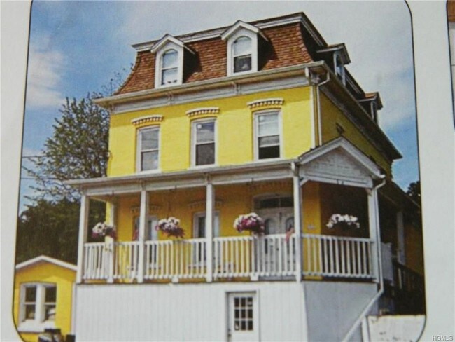
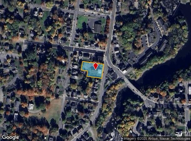
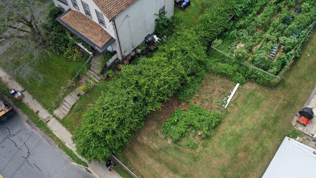
50 S Montgomery St, Walden, NY 12586

NEARBY LISTINGS FOR SALE OR LEASE
-
-
View all Walden listings for sale on LoopNet.com
Property Detail
50 S Montgomery St
334205-308-000-0002-004.000-0000
Orange
Apartment
New York
X
4.000
36071C0112E
0.60 AC
2024
Outlying Orange County
2024
Northern New Jersey
010701
New York-Jersey City-White Plains, NY-NJ
4,113 SF
DEMOGRAPHICS near 50 S Montgomery St
1 Mile
3 Mile
5 Mile
2024 Total Population
7,540
13,961
30,671
2029 Population
7,690
14,210
31,000
Pop Growth 2024-2029
+ 1.99%
+ 1.78%
+ 1.07%
Average Age
38
40
41
2024 Total Households
2,703
4,813
10,751
HH Growth 2024-2029
+ 2.07%
+ 1.83%
+ 1.10%
Median Household Inc
$75,034
$90,516
$96,374
Avg Household Size
2.70
2.70
2.70
2024 Avg HH Vehicles
2.00
2.00
2.00
Median Home Value
$277,548
$304,828
$308,863
Median Year Built
1961
1968
1973
Nearby Places
- Restaurants
- Banks
- Shops
- Fitness
- Groceries
PUBLIC TRANSPORTATION
AIRPORT
New York Stewart International
DRIVE
WALK
Distance
New York Stewart International
18 min
10.8 mi
Freight Ports
Port Newark Container Terminal
DRIVE
WALK
Distance
Port Newark Container Terminal
102 min
76.9 mi
SALE & LEASE HISTORY
LISTING DATE
SALE/LEASE

Sep 04, 2018
For Sale
May 10, 2018
For Sale
Mar 04, 2021
For Sale
Jun 20, 2017
For Sale
Aug 17, 2020
For Sale
Nearby Properties
Address
Land Use
TOTAL SIZE
Lot Size
Zoning
Address
Land Use
TOTAL SIZE
Lot Size
Zoning
108.50 AC
Address
Land Use
TOTAL SIZE
Lot Size
Zoning
26,500 SF
27.50 AC
B4
Address
Land Use
TOTAL SIZE
Lot Size
Zoning
100,300 SF
22.50 AC
I1
Address
Land Use
TOTAL SIZE
Lot Size
Zoning
221,958 SF
12.10 AC
ID
Address
Land Use
TOTAL SIZE
Lot Size
Zoning
109,108 SF
15.60 AC
B2
Address
Land Use
TOTAL SIZE
Lot Size
Zoning
89,960 SF
10.90 AC
I1
Address
Land Use
TOTAL SIZE
Lot Size
Zoning
49,056 SF
20 AC
RM1
Address
Land Use
TOTAL SIZE
Lot Size
Zoning
32,505 SF
15.10 AC
I1
Address
Land Use
TOTAL SIZE
Lot Size
Zoning
38,624 SF
11.50 AC
I1
Address
Land Use
TOTAL SIZE
Lot Size
Zoning
80,260 SF
9.30 AC
I1
Address
Land Use
TOTAL SIZE
Lot Size
Zoning
14,376 SF
63.90 AC
01
Address
Land Use
TOTAL SIZE
Lot Size
Zoning
72,852 SF
2.20 AC
Address
Land Use
TOTAL SIZE
Lot Size
Zoning
102,239 SF
62.90 AC
RA2
Address
Land Use
TOTAL SIZE
Lot Size
Zoning
88,416 SF
4.20 AC
R2
Address
Land Use
TOTAL SIZE
Lot Size
Zoning
64,191 SF
10 AC
06
Address
Land Use
TOTAL SIZE
Lot Size
Zoning
85,275 SF
70.20 AC
RA-.5
Address
Land Use
TOTAL SIZE
Lot Size
Zoning
28,443 SF
34.70 AC
04OP
Address
Land Use
TOTAL SIZE
Lot Size
Zoning
18,386 SF
54.70 AC
RA-.5
Address
Land Use
TOTAL SIZE
Lot Size
Zoning
74,046 SF
58.30 AC
Address
Land Use
TOTAL SIZE
Lot Size
Zoning
195,821 SF
27.50 AC
I1
Address
Land Use
TOTAL SIZE
Lot Size
Zoning
111,517 SF
0.32 AC
R3
Address
Land Use
TOTAL SIZE
Lot Size
Zoning
39,158 SF
20.50 AC
01
Address
Land Use
TOTAL SIZE
Lot Size
Zoning
Address
Land Use
TOTAL SIZE
Lot Size
Zoning
87,952 SF
9.80 AC
I1
Address
Land Use
TOTAL SIZE
Lot Size
Zoning
35,988 SF
14.90 AC
Address
Land Use
TOTAL SIZE
Lot Size
Zoning
82,465 SF
14.40 AC
I1
Address
Land Use
TOTAL SIZE
Lot Size
Zoning
49,918 SF
5 AC
I1
Address
Land Use
TOTAL SIZE
Lot Size
Zoning
26,988 SF
53 AC
RA2
Address
Land Use
TOTAL SIZE
Lot Size
Zoning
2.10 AC
R5
Address
Land Use
TOTAL SIZE
Lot Size
Zoning
78,179 SF
30.50 AC
I1
The World's #1 Commercial Real Estate Marketplace
Connect with us
© 2025 CoStar Group
The information above has been obtained from sources believed reliable. While we do not doubt its accuracy we have not verified it and make no guarantee, warranty or representation about it. It is your responsibility to independently confirm its accuracy and completeness. Any projections, opinions, assumptions, or estimates used are for example only and do not represent the current or future performance of the property. The value of this transaction to you depends on tax and other factors which should be evaluated by your tax, financial, and legal advisors. You and your advisors should conduct a careful, independent investigation of the property to determine to your satisfaction the suitability of the property for your needs.