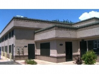
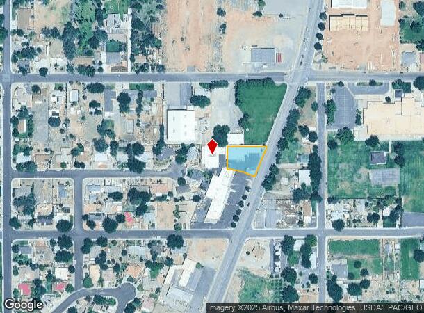
Property Record
50 S State St, La Verkin, UT 84745

NEARBY LISTINGS FOR SALE OR LEASE
-
-
View all La Verkin listings for sale on LoopNet.com
Property Detail
50 S State St
St. George, UT
La Verkin Field Sur
0540586
SUBDIVISION: LA VERKIN FIELD SUR LOT 32 (LV) BEG S0*14 E ALG L/L 285.68 FT & N89*46 E 281.71 FT FM NW COR LOT 32 LVFS TH N89*46 E 176.47 FT TO WLY R/W/L HWY U-9; TH S21*0845 W ALG R/W/L 144.42 FT; TH N68*5151 W 39.07 FT TO BEG 265.055 FT RAD CUR; TH
Commercialnec
Washington
X
Utah
49053C0835G
32
2024
0.41 AC
2025
Cedar City & St George
271000
Other Market Areas
11,000 SF
DEMOGRAPHICS near 50 S State St
1 Mile
3 Mile
5 Mile
2024 Total Population
4,319
13,080
20,658
2029 Population
5,274
15,972
25,394
Pop Growth 2024-2029
+ 22.11%
+ 22.11%
+ 22.93%
Average Age
38
38
40
2024 Total Households
1,370
4,099
6,941
HH Growth 2024-2029
+ 22.70%
+ 22.74%
+ 23.71%
Median Household Inc
$47,263
$54,212
$55,557
Avg Household Size
3.10
3.10
2.90
2024 Avg HH Vehicles
2.00
2.00
2.00
Median Home Value
$280,418
$344,659
$370,040
Median Year Built
1992
1993
1999
Nearby Places
Map Layers
Map Styles
 Street
 Aerial
- Restaurants
- Banks
- Shops
- Fitness
- Groceries
PUBLIC TRANSPORTATION
AIRPORT
St George Regional
DRIVE
WALK
Distance
St George Regional
36 min
22.3 mi
Nearby Properties
Address
Land Use
TOTAL SIZE
Lot Size
Zoning
Address
Land Use
TOTAL SIZE
Lot Size
Zoning
93,494 SF
23.97 AC
PF
Address
Land Use
TOTAL SIZE
Lot Size
Zoning
70,194 SF
2.79 AC
Address
Land Use
TOTAL SIZE
Lot Size
Zoning
55,676 SF
8.90 AC
PF
Address
Land Use
TOTAL SIZE
Lot Size
Zoning
50,591 SF
2.27 AC
Address
Land Use
TOTAL SIZE
Lot Size
Zoning
48,863 SF
1.72 AC
HC
Address
Land Use
TOTAL SIZE
Lot Size
Zoning
13,516 SF
11.45 AC
Address
Land Use
TOTAL SIZE
Lot Size
Zoning
38,940 SF
1.03 AC
Address
Land Use
TOTAL SIZE
Lot Size
Zoning
40,650 SF
2.99 AC
Address
Land Use
TOTAL SIZE
Lot Size
Zoning
30,643 SF
26.13 AC
PDO
Address
Land Use
TOTAL SIZE
Lot Size
Zoning
33,657 SF
12.90 AC
Address
Land Use
TOTAL SIZE
Lot Size
Zoning
134,714 SF
14.80 AC
M-1
Address
Land Use
TOTAL SIZE
Lot Size
Zoning
42,267 SF
3.09 AC
HC
Address
Land Use
TOTAL SIZE
Lot Size
Zoning
22,080 SF
6.82 AC
HC
Address
Land Use
TOTAL SIZE
Lot Size
Zoning
30,519 SF
5.76 AC
HC
Address
Land Use
TOTAL SIZE
Lot Size
Zoning
22,576 SF
5.35 AC
Address
Land Use
TOTAL SIZE
Lot Size
Zoning
23,586 SF
3.52 AC
HC
Address
Land Use
TOTAL SIZE
Lot Size
Zoning
48,990 SF
24.69 AC
PF
Address
Land Use
TOTAL SIZE
Lot Size
Zoning
34,486 SF
3.03 AC
HC
Address
Land Use
TOTAL SIZE
Lot Size
Zoning
41,124 SF
4.83 AC
Address
Land Use
TOTAL SIZE
Lot Size
Zoning
14,739 SF
1.48 AC
HC
Address
Land Use
TOTAL SIZE
Lot Size
Zoning
25,105 SF
2.97 AC
Address
Land Use
TOTAL SIZE
Lot Size
Zoning
22,435 SF
0.74 AC
HC
Address
Land Use
TOTAL SIZE
Lot Size
Zoning
10,930 SF
4.22 AC
HC
Address
Land Use
TOTAL SIZE
Lot Size
Zoning
10,394 SF
1.81 AC
HC
Address
Land Use
TOTAL SIZE
Lot Size
Zoning
87,486 SF
3.06 AC
Address
Land Use
TOTAL SIZE
Lot Size
Zoning
10,491 SF
10.93 AC
Address
Land Use
TOTAL SIZE
Lot Size
Zoning
6,550 SF
60 AC
OSC20
Address
Land Use
TOTAL SIZE
Lot Size
Zoning
7,937 SF
1.64 AC
HC
Address
Land Use
TOTAL SIZE
Lot Size
Zoning
7,326 SF
1.39 AC
The World's #1 Commercial Real Estate Marketplace
Connect with us
© 2026 CoStar Group
The information above has been obtained from sources believed reliable. While we do not doubt its accuracy we have not verified it and make no guarantee, warranty or representation about it. It is your responsibility to independently confirm its accuracy and completeness. Any projections, opinions, assumptions, or estimates used are for example only and do not represent the current or future performance of the property. The value of this transaction to you depends on tax and other factors which should be evaluated by your tax, financial, and legal advisors. You and your advisors should conduct a careful, independent investigation of the property to determine to your satisfaction the suitability of the property for your needs.