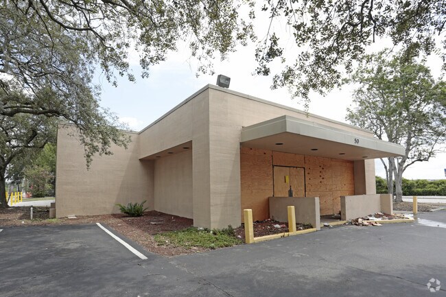
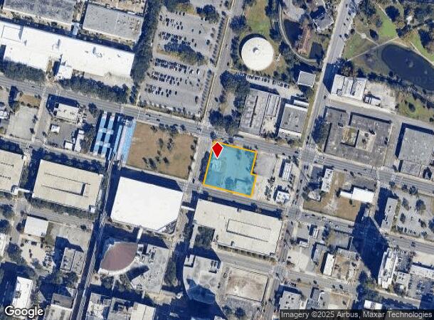
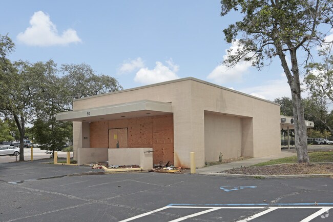
Property Record
50 Union St W, Jacksonville, FL 32202
NEARBY LISTINGS FOR SALE OR LEASE
Property Detail
50 Union St W
Jacksonville, FL
Jacksonville Harts Map
074149-0000
39-2S-26E JAX HARTS MAP LOTS 1,2,5,6,W1/4 LOT 3 BLOCK 93
Commercialacreage
Duval
X
Florida
12031C0358J
1,2,5
2024
1.07 AC
2025
Downtown Northbank
017200
Jacksonville (Florida)
6,165 SF
DEMOGRAPHICS near 50 Union St W
1 Mile
3 Mile
5 Mile
2024 Total Population
14,543
87,280
220,640
2029 Population
15,528
93,256
233,156
Pop Growth 2024-2029
+ 6.77%
+ 6.85%
+ 5.67%
Average Age
41
39
39
2024 Total Households
5,931
37,518
91,474
HH Growth 2024-2029
+ 7.84%
+ 7.20%
+ 5.92%
Median Household Inc
$33,325
$33,710
$42,050
Avg Household Size
1.80
2.10
2.30
2024 Avg HH Vehicles
1.00
1.00
1.00
Median Home Value
$297,499
$171,283
$177,603
Median Year Built
1968
1960
1961
Nearby Places
Map Layers
Map Styles
 Street
 Aerial
- Restaurants
- Banks
- Shops
- Fitness
- Groceries
PUBLIC TRANSPORTATION
TRANSIT/SUBWAY
Rosa L. Parks/Fccj (Skyway - Jacksonville Transit Authority Skyway (The Skyway))
DRIVE
WALK
Distance
Rosa L. Parks/Fccj (Skyway - Jacksonville Transit Authority Skyway (The Skyway))
0 min
2 min
0.1 mi
Hemming Plaza (Skyway - Jacksonville Transit Authority Skyway (The Skyway))
DRIVE
WALK
Distance
Hemming Plaza (Skyway - Jacksonville Transit Authority Skyway (The Skyway))
2 min
6 min
0.4 mi
Central (Skyway - Jacksonville Transit Authority Skyway (The Skyway))
DRIVE
WALK
Distance
Central (Skyway - Jacksonville Transit Authority Skyway (The Skyway))
2 min
12 min
0.7 mi
Jefferson Street (Skyway - Jacksonville Transit Authority Skyway (The Skyway))
DRIVE
WALK
Distance
Jefferson Street (Skyway - Jacksonville Transit Authority Skyway (The Skyway))
2 min
18 min
0.9 mi
COMMUTER RAIL
Jacksonville (Silver Meteor - Amtrak, Silver Star - Amtrak)
DRIVE
WALK
Distance
Jacksonville (Silver Meteor - Amtrak, Silver Star - Amtrak)
11 min
5.9 mi
AIRPORT
Jacksonville International
DRIVE
WALK
Distance
Jacksonville International
22 min
14.5 mi
Freight Ports
Jacksonville Port
DRIVE
WALK
Distance
Jacksonville Port
9 min
4.4 mi
SALE & LEASE HISTORY
LISTING DATE
SALE/LEASE

Sep 24, 2016
For Sale
Jun 29, 2017
For Sale
Dec 06, 2021
For Lease
Aug 01, 2017
For Sale
Apr 03, 2017
For Sale
Nearby Properties
Address
Land Use
TOTAL SIZE
Lot Size
Zoning
Address
Land Use
TOTAL SIZE
Lot Size
Zoning
1,086,885 SF
16.83 AC
CCBD
Address
Land Use
TOTAL SIZE
Lot Size
Zoning
543,383 SF
7.87 AC
CCBD
Address
Land Use
TOTAL SIZE
Lot Size
Zoning
1,150,143 SF
43.90 AC
CCBD
Address
Land Use
TOTAL SIZE
Lot Size
Zoning
629,200 SF
9.64 AC
PUD
Address
Land Use
TOTAL SIZE
Lot Size
Zoning
705,940 SF
25.12 AC
PBF-1
Address
Land Use
TOTAL SIZE
Lot Size
Zoning
442,972 SF
5.33 AC
PUD
Address
Land Use
TOTAL SIZE
Lot Size
Zoning
407,122 SF
4.50 AC
CCBD
Address
Land Use
TOTAL SIZE
Lot Size
Zoning
165,408 SF
2.45 AC
CCBD
Address
Land Use
TOTAL SIZE
Lot Size
Zoning
521,850 SF
10.06 AC
CCBD
Address
Land Use
TOTAL SIZE
Lot Size
Zoning
831,560 SF
1.16 AC
PUD
Address
Land Use
TOTAL SIZE
Lot Size
Zoning
187,278 SF
1.71 AC
CCBD
Address
Land Use
TOTAL SIZE
Lot Size
Zoning
127,732 SF
1.44 AC
CCBD
Address
Land Use
TOTAL SIZE
Lot Size
Zoning
313,472 SF
35.44 AC
CCBD
Address
Land Use
TOTAL SIZE
Lot Size
Zoning
146,636 SF
2.88 AC
CCBD
Address
Land Use
TOTAL SIZE
Lot Size
Zoning
264,277 SF
2.07 AC
CCBD
Address
Land Use
TOTAL SIZE
Lot Size
Zoning
369,638 SF
6.30 AC
CCBD
Address
Land Use
TOTAL SIZE
Lot Size
Zoning
326,485 SF
1.56 AC
CCBD
Address
Land Use
TOTAL SIZE
Lot Size
Zoning
992,501 SF
2.97 AC
CCBD
Address
Land Use
TOTAL SIZE
Lot Size
Zoning
503,858 SF
1.32 AC
CCBD
Address
Land Use
TOTAL SIZE
Lot Size
Zoning
194,877 SF
11.64 AC
CCBD
Address
Land Use
TOTAL SIZE
Lot Size
Zoning
336,623 SF
1.98 AC
CCBD
Address
Land Use
TOTAL SIZE
Lot Size
Zoning
453,728 SF
8.20 AC
CCBD
Address
Land Use
TOTAL SIZE
Lot Size
Zoning
299,055 SF
18.93 AC
CCBD
Address
Land Use
TOTAL SIZE
Lot Size
Zoning
290,975 SF
4.49 AC
PUD
Address
Land Use
TOTAL SIZE
Lot Size
Zoning
355,967 SF
8.98 AC
PUD
Address
Land Use
TOTAL SIZE
Lot Size
Zoning
224,600 SF
3.41 AC
PUD
Address
Land Use
TOTAL SIZE
Lot Size
Zoning
253,858 SF
4.93 AC
PUD
Address
Land Use
TOTAL SIZE
Lot Size
Zoning
212,152 SF
8.17 AC
CCBD
Address
Land Use
TOTAL SIZE
Lot Size
Zoning
270,000 SF
8.90 AC
PUD
Address
Land Use
TOTAL SIZE
Lot Size
Zoning
700,443 SF
8 AC
CCBD
The World's #1 Commercial Real Estate Marketplace
Connect with us
© 2025 CoStar Group
The information above has been obtained from sources believed reliable. While we do not doubt its accuracy we have not verified it and make no guarantee, warranty or representation about it. It is your responsibility to independently confirm its accuracy and completeness. Any projections, opinions, assumptions, or estimates used are for example only and do not represent the current or future performance of the property. The value of this transaction to you depends on tax and other factors which should be evaluated by your tax, financial, and legal advisors. You and your advisors should conduct a careful, independent investigation of the property to determine to your satisfaction the suitability of the property for your needs.