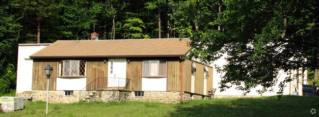
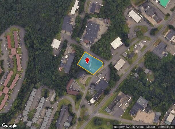
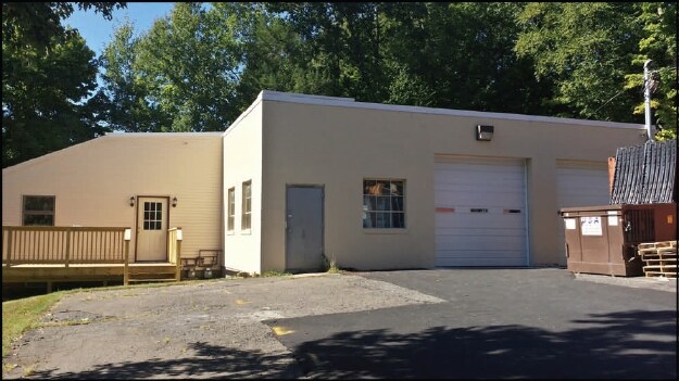
Property Record
50 Wakelee Rd, Wolcott, CT 06716

NEARBY LISTINGS FOR SALE OR LEASE
Property Detail
50 Wakelee Rd
WOLC-000109-000004-000015
New Haven
Industrialgeneral
Connecticut
X
15
09009C0109H
0.81 AC
2025
Waterbury
2025
Westchester/So Connecticut
361200
New Haven, CT
4,160 SF
DEMOGRAPHICS near 50 Wakelee Rd
1 mile
3 mile
5 mile
2024 Total Population
5,686
87,999
153,147
2029 Population
5,718
87,711
152,518
Pop Growth 2024-2029
+ 0.56%
(0.33%)
(0.41%)
Average Age
39
38
39
2024 Total Households
2,414
33,964
59,221
HH Growth 2024-2029
+ 0.46%
(0.30%)
(0.42%)
Median Household Inc
$45,658
$47,536
$58,304
Avg Household Size
2.30
2.50
2.50
2024 Avg HH Vehicles
1.00
1.00
2.00
Median Home Value
$160,173
$174,971
$190,154
Median Year Built
1975
1959
1962
Nearby Places
Map Layers
Map Styles
 Street
 Aerial
Transit
 Traffic
 Biking
Places
Listings with unknown addresses are not visible on the map
- Restaurants
- Banks
- Shops
- Fitness
- Groceries
PUBLIC TRANSPORTATION
COMMUTER RAIL
Waterbury Station (New Haven Line - Metro-North Commuter Railroad Company (Metro-North))
Drive
Walk
Distance
Waterbury Station (New Haven Line - Metro-North Commuter Railroad Company (Metro-North))
8 min
3.7 mi
Naugatuck Station (New Haven Line - Metro-North Commuter Railroad Company (Metro-North))
Drive
Walk
Distance
Naugatuck Station (New Haven Line - Metro-North Commuter Railroad Company (Metro-North))
13 min
7.9 mi
AIRPORT
Tweed/New Haven
Drive
Walk
Distance
Tweed/New Haven
48 min
28.1 mi
Bradley International
Drive
Walk
Distance
Bradley International
62 min
40.8 mi
Freight Ports
Port of New Haven
Drive
Walk
Distance
Port of New Haven
42 min
25.5 mi
Nearby Properties
Address
Land Use
TOTAL SIZE
Lot Size
Zoning
Address
Land Use
TOTAL SIZE
Lot Size
Zoning
77.50 AC
RS
Address
Land Use
TOTAL SIZE
Lot Size
Zoning
306,366 SF
84 AC
RS-12
Address
Land Use
TOTAL SIZE
Lot Size
Zoning
195,000 SF
1.41 AC
CBD
Address
Land Use
TOTAL SIZE
Lot Size
Zoning
1.86 AC
CBD
Address
Land Use
TOTAL SIZE
Lot Size
Zoning
1.30 AC
CBD
Address
Land Use
TOTAL SIZE
Lot Size
Zoning
88,350 SF
9.50 AC
RS
Address
Land Use
TOTAL SIZE
Lot Size
Zoning
97,695 SF
0.57 AC
CBD
Address
Land Use
TOTAL SIZE
Lot Size
Zoning
118,884 SF
13.40 AC
RL
Address
Land Use
TOTAL SIZE
Lot Size
Zoning
70,857 SF
1.71 AC
CBD
Address
Land Use
TOTAL SIZE
Lot Size
Zoning
129,672 SF
8 AC
IG
Address
Land Use
TOTAL SIZE
Lot Size
Zoning
103,254 SF
2.03 AC
CBD
Address
Land Use
TOTAL SIZE
Lot Size
Zoning
97,386 SF
53.20 AC
RS
Address
Land Use
TOTAL SIZE
Lot Size
Zoning
44.31 AC
CA
Address
Land Use
TOTAL SIZE
Lot Size
Zoning
54,580 SF
0.65 AC
CBD
Address
Land Use
TOTAL SIZE
Lot Size
Zoning
45,605 SF
2.48 AC
RH
Address
Land Use
TOTAL SIZE
Lot Size
Zoning
95,000 SF
9.30 AC
RM
Address
Land Use
TOTAL SIZE
Lot Size
Zoning
5.13 AC
RM
Address
Land Use
TOTAL SIZE
Lot Size
Zoning
39 AC
RM
Address
Land Use
TOTAL SIZE
Lot Size
Zoning
19.24 AC
CA
Address
Land Use
TOTAL SIZE
Lot Size
Zoning
35,860 SF
1.29 AC
CBD
Address
Land Use
TOTAL SIZE
Lot Size
Zoning
419,566 SF
0.35 AC
CBD
Address
Land Use
TOTAL SIZE
Lot Size
Zoning
50 AC
R-40
Address
Land Use
TOTAL SIZE
Lot Size
Zoning
56,580 SF
1.13 AC
CBD
Address
Land Use
TOTAL SIZE
Lot Size
Zoning
24.49 AC
CA
Address
Land Use
TOTAL SIZE
Lot Size
Zoning
12.49 AC
CA
Address
Land Use
TOTAL SIZE
Lot Size
Zoning
31.75 AC
CA
Address
Land Use
TOTAL SIZE
Lot Size
Zoning
18.01 AC
CA
Address
Land Use
TOTAL SIZE
Lot Size
Zoning
10.51 AC
RL
Address
Land Use
TOTAL SIZE
Lot Size
Zoning
91,324 SF
22.27 AC
RM
Address
Land Use
TOTAL SIZE
Lot Size
Zoning
25,474 SF
20.35 AC
RM
The World's #1 Commercial Real Estate Marketplace
Connect with us
© 2026 CoStar Group
The information above has been obtained from sources believed reliable. While we do not doubt its accuracy we have not verified it and make no guarantee, warranty or representation about it. It is your responsibility to independently confirm its accuracy and completeness. Any projections, opinions, assumptions, or estimates used are for example only and do not represent the current or future performance of the property. The value of this transaction to you depends on tax and other factors which should be evaluated by your tax, financial, and legal advisors. You and your advisors should conduct a careful, independent investigation of the property to determine to your satisfaction the suitability of the property for your needs.