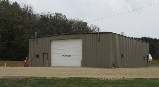
Property Record
500 2Nd Ave Nw, Oronoco, MN 55960

NEARBY LISTINGS FOR SALE OR LEASE
Property Detail
500 2Nd Ave Nw
84.08.32.046325
City Lands 108-14-08
Warehouse
SECT-08 TWP-108 RANGE-014 CITY LANDS 108-14-08 2.28 AC TH PT NW14 SW14 DES AS FOL COM AT NWCOR SD SW14 TH S AL W LINE SD SW14
X
Olmsted
27109C0041E
Minnesota
2025
1.66 AC
2024
Other Market Areas
001902
Rochester, MN
3,000 SF
DEMOGRAPHICS near 500 2Nd Ave Nw
1 Mile
3 Mile
5 Mile
2024 Total Population
797
2,334
5,735
2029 Population
796
2,335
5,788
Pop Growth 2024-2029
(0.13%)
+ 0.04%
+ 0.92%
Average Age
38
38
40
2024 Total Households
261
782
2,053
HH Growth 2024-2029
(0.38%)
(0.13%)
+ 0.78%
Median Household Inc
$132,720
$131,044
$117,675
Avg Household Size
3.00
3.00
2.80
2024 Avg HH Vehicles
3.00
3.00
3.00
Median Home Value
$398,245
$402,795
$405,793
Median Year Built
1991
1990
1987
Nearby Places
Map Layers
Map Styles
 Street
 Aerial
- Restaurants
- Banks
- Shops
- Fitness
- Groceries
PUBLIC TRANSPORTATION
AIRPORT
Rochester International
DRIVE
WALK
Distance
Rochester International
29 min
20.4 mi
SALE & LEASE HISTORY
LISTING DATE
SALE/LEASE

Feb 13, 2019
For Sale
Nearby Properties
Address
Land Use
TOTAL SIZE
Lot Size
Zoning
Address
Land Use
TOTAL SIZE
Lot Size
Zoning
77,297 SF
18.92 AC
Address
Land Use
TOTAL SIZE
Lot Size
Zoning
32,432 SF
16.45 AC
Address
Land Use
TOTAL SIZE
Lot Size
Zoning
17,280 SF
11.97 AC
Address
Land Use
TOTAL SIZE
Lot Size
Zoning
10,400 SF
9.99 AC
Address
Land Use
TOTAL SIZE
Lot Size
Zoning
2,872 SF
20 AC
Address
Land Use
TOTAL SIZE
Lot Size
Zoning
40,632 SF
35.71 AC
Address
Land Use
TOTAL SIZE
Lot Size
Zoning
149.68 AC
Address
Land Use
TOTAL SIZE
Lot Size
Zoning
1,312 SF
16.40 AC
Address
Land Use
TOTAL SIZE
Lot Size
Zoning
1,656 SF
160 AC
Address
Land Use
TOTAL SIZE
Lot Size
Zoning
96 SF
133.10 AC
Address
Land Use
TOTAL SIZE
Lot Size
Zoning
1,642 SF
155 AC
Address
Land Use
TOTAL SIZE
Lot Size
Zoning
38,668 SF
5.71 AC
Address
Land Use
TOTAL SIZE
Lot Size
Zoning
17,408 SF
0.58 AC
Address
Land Use
TOTAL SIZE
Lot Size
Zoning
1,052 SF
11 AC
Address
Land Use
TOTAL SIZE
Lot Size
Zoning
2,640 SF
77.30 AC
Address
Land Use
TOTAL SIZE
Lot Size
Zoning
8,369 SF
8.01 AC
Address
Land Use
TOTAL SIZE
Lot Size
Zoning
Address
Land Use
TOTAL SIZE
Lot Size
Zoning
Address
Land Use
TOTAL SIZE
Lot Size
Zoning
1,750 SF
120 AC
Address
Land Use
TOTAL SIZE
Lot Size
Zoning
1,020 SF
6.79 AC
Address
Land Use
TOTAL SIZE
Lot Size
Zoning
2,384 SF
91.20 AC
Address
Land Use
TOTAL SIZE
Lot Size
Zoning
3,600 SF
1.29 AC
Address
Land Use
TOTAL SIZE
Lot Size
Zoning
1,600 SF
3.56 AC
Address
Land Use
TOTAL SIZE
Lot Size
Zoning
1,420 SF
57.26 AC
Address
Land Use
TOTAL SIZE
Lot Size
Zoning
79.60 AC
Address
Land Use
TOTAL SIZE
Lot Size
Zoning
1,344 SF
84.96 AC
Address
Land Use
TOTAL SIZE
Lot Size
Zoning
Address
Land Use
TOTAL SIZE
Lot Size
Zoning
65.69 AC
The World's #1 Commercial Real Estate Marketplace
Connect with us
© 2026 CoStar Group
The information above has been obtained from sources believed reliable. While we do not doubt its accuracy we have not verified it and make no guarantee, warranty or representation about it. It is your responsibility to independently confirm its accuracy and completeness. Any projections, opinions, assumptions, or estimates used are for example only and do not represent the current or future performance of the property. The value of this transaction to you depends on tax and other factors which should be evaluated by your tax, financial, and legal advisors. You and your advisors should conduct a careful, independent investigation of the property to determine to your satisfaction the suitability of the property for your needs.