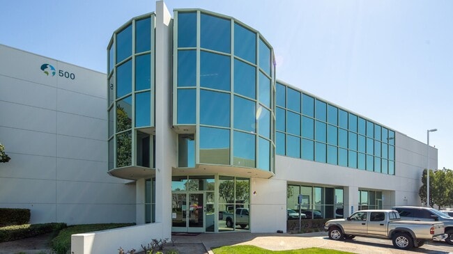
Property Record
500 Burning Tree Rd, Fullerton, CA 92833


Current Lease Availabilities
Property Detail
500 Burning Tree Rd
280-212-02
N TR 13221 BLK LOT 6 TR NO 13221 LOT 6 POR OF LOT
Industrialgeneral
ORANGE
MG
California
C and X Area of minimal flood hazard, usually depicted on FIRMs as above the 500-year flood level.
6
2024
4.32 AC
2025
Fullerton
110605
Orange County (California)
110,445 SF
Anaheim-Santa Ana-Irvine, CA
NEARBY LISTINGS FOR SALE OR LEASE
DEMOGRAPHICS near 500 Burning Tree Rd
1 mile
3 mile
5 mile
2024 Total Population
22,745
202,462
616,880
2029 Population
22,459
201,648
614,379
Pop Growth 2024-2029
(1.26%)
(0.40%)
(0.41%)
Average Age
39
40
40
2024 Total Households
7,082
62,089
188,430
HH Growth 2024-2029
(1.64%)
(0.63%)
(0.60%)
Median Household Inc
$107,988
$100,630
$96,856
Avg Household Size
3.10
3.10
3.10
2024 Avg HH Vehicles
2.00
2.00
2.00
Median Home Value
$844,436
$805,479
$777,766
Median Year Built
1974
1969
1967
Nearby Places
Map Layers
Map Styles
 Street
 Aerial
Transit
 Traffic
 Biking
Places
Listings with unknown addresses are not visible on the map
- Restaurants
- Banks
- Shops
- Fitness
- Groceries
PUBLIC TRANSPORTATION
COMMUTER RAIL
Buena Park (91 Line - Southern California Regional Rail Authority (Metrolink), Orange County Line - Southern California Regional Rail Authority (Metrolink))
Drive
Walk
Distance
Buena Park (91 Line - Southern California Regional Rail Authority (Metrolink), Orange County Line - Southern California Regional Rail Authority (Metrolink))
4 min
1.3 mi
Fullerton (91 Line - Southern California Regional Rail Authority (Metrolink), Orange County Line - Southern California Regional Rail Authority (Metrolink))
Drive
Walk
Distance
Fullerton (91 Line - Southern California Regional Rail Authority (Metrolink), Orange County Line - Southern California Regional Rail Authority (Metrolink))
9 min
3.6 mi
AIRPORT
Long Beach (Daugherty Field)
Drive
Walk
Distance
Long Beach (Daugherty Field)
29 min
16.5 mi
John Wayne/Orange County
Drive
Walk
Distance
John Wayne/Orange County
28 min
19.4 mi
Los Angeles International
Drive
Walk
Distance
Los Angeles International
41 min
28.6 mi
Nearby Properties
Address
Land Use
TOTAL SIZE
Lot Size
Zoning
Address
Land Use
TOTAL SIZE
Lot Size
Zoning
Address
Land Use
TOTAL SIZE
Lot Size
Zoning
57.25 AC
Address
Land Use
TOTAL SIZE
Lot Size
Zoning
476,442 SF
22.77 AC
Address
Land Use
TOTAL SIZE
Lot Size
Zoning
437,823 SF
19.27 AC
LMM2*
Address
Land Use
TOTAL SIZE
Lot Size
Zoning
12.50 AC
Address
Land Use
TOTAL SIZE
Lot Size
Zoning
281,238 SF
14.83 AC
Address
Land Use
TOTAL SIZE
Lot Size
Zoning
Address
Land Use
TOTAL SIZE
Lot Size
Zoning
47,520 SF
1.92 AC
C
Address
Land Use
TOTAL SIZE
Lot Size
Zoning
225,016 SF
9.95 AC
LMM2*
Address
Land Use
TOTAL SIZE
Lot Size
Zoning
13.75 AC
Address
Land Use
TOTAL SIZE
Lot Size
Zoning
Address
Land Use
TOTAL SIZE
Lot Size
Zoning
5.90 AC
Address
Land Use
TOTAL SIZE
Lot Size
Zoning
26.92 AC
Address
Land Use
TOTAL SIZE
Lot Size
Zoning
215,384 SF
8.82 AC
Address
Land Use
TOTAL SIZE
Lot Size
Zoning
12,040 SF
1.82 AC
Address
Land Use
TOTAL SIZE
Lot Size
Zoning
140,973 SF
10.03 AC
Address
Land Use
TOTAL SIZE
Lot Size
Zoning
277,756 SF
10.47 AC
LMM2*
Address
Land Use
TOTAL SIZE
Lot Size
Zoning
46.74 AC
Address
Land Use
TOTAL SIZE
Lot Size
Zoning
24.80 AC
Address
Land Use
TOTAL SIZE
Lot Size
Zoning
249,572 SF
11.76 AC
LMM2*
Address
Land Use
TOTAL SIZE
Lot Size
Zoning
237,944 SF
12.09 AC
LMM2*
Address
Land Use
TOTAL SIZE
Lot Size
Zoning
19.26 AC
Address
Land Use
TOTAL SIZE
Lot Size
Zoning
140,212 SF
6.65 AC
LMM2*
Address
Land Use
TOTAL SIZE
Lot Size
Zoning
21.64 AC
Address
Land Use
TOTAL SIZE
Lot Size
Zoning
1,102,724 SF
25.93 AC
LMM2*
Address
Land Use
TOTAL SIZE
Lot Size
Zoning
201,681 SF
7.81 AC
R3
Address
Land Use
TOTAL SIZE
Lot Size
Zoning
13.88 AC
Address
Land Use
TOTAL SIZE
Lot Size
Zoning
Address
Land Use
TOTAL SIZE
Lot Size
Zoning
964 SF
8.83 AC
Address
Land Use
TOTAL SIZE
Lot Size
Zoning
10.67 AC
The World's #1 Commercial Real Estate Marketplace
Connect with us
© 2026 CoStar Group
The information above has been obtained from sources believed reliable. While we do not doubt its accuracy we have not verified it and make no guarantee, warranty or representation about it. It is your responsibility to independently confirm its accuracy and completeness. Any projections, opinions, assumptions, or estimates used are for example only and do not represent the current or future performance of the property. The value of this transaction to you depends on tax and other factors which should be evaluated by your tax, financial, and legal advisors. You and your advisors should conduct a careful, independent investigation of the property to determine to your satisfaction the suitability of the property for your needs.