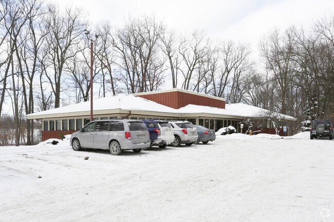
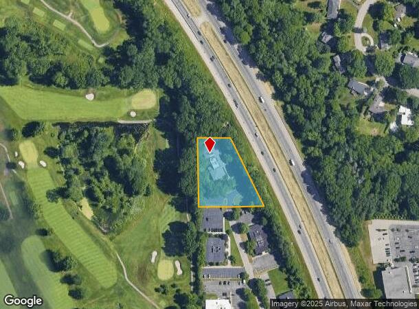
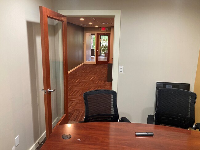
Property Record
500 Cascade West Pky Se, Grand Rapids, MI 49546
Current Lease Availabilities
NEARBY LISTINGS FOR SALE OR LEASE
Property Detail
500 Cascade West Pky Se
41-14-36-151-016
PART NW 1/4 COM 252.62 FT S 0D 40M 56S E ALONG W SEC LINE & 40 FT S 89D 34M 56S E FROM NW COR OF SEC TH S 0D 40M 56S E 287.59
Officebuilding
Kent
X
Michigan
26081C0429D
1.35 AC
2024
Ada/Lowell
2025
West Michigan
011804
Grand Rapids-Wyoming-Kentwood, MI
14,036 SF
DEMOGRAPHICS near 500 Cascade West Pky Se
1 Mile
3 Mile
5 Mile
2024 Total Population
4,428
52,360
171,152
2029 Population
4,516
52,776
172,274
Pop Growth 2024-2029
+ 1.99%
+ 0.79%
+ 0.66%
Average Age
46
39
38
2024 Total Households
1,700
18,985
68,218
HH Growth 2024-2029
+ 2.24%
+ 0.81%
+ 0.64%
Median Household Inc
$102,678
$102,580
$73,439
Avg Household Size
2.40
2.50
2.40
2024 Avg HH Vehicles
2.00
2.00
2.00
Median Home Value
$361,849
$373,136
$272,051
Median Year Built
1983
1975
1966
Nearby Places
Map Layers
Map Styles
 Street
 Aerial
- Restaurants
- Banks
- Shops
- Fitness
- Groceries
PUBLIC TRANSPORTATION
COMMUTER RAIL
DRIVE
WALK
Distance
13 min
6.4 mi
AIRPORT
Gerald R Ford International
DRIVE
WALK
Distance
Gerald R Ford International
17 min
8.7 mi
Nearby Properties
Address
Land Use
TOTAL SIZE
Lot Size
Zoning
Address
Land Use
TOTAL SIZE
Lot Size
Zoning
563,998 SF
31.75 AC
C3
Address
Land Use
TOTAL SIZE
Lot Size
Zoning
521,735 SF
52.16 AC
MON-C
Address
Land Use
TOTAL SIZE
Lot Size
Zoning
709,488 SF
106.95 AC
LI
Address
Land Use
TOTAL SIZE
Lot Size
Zoning
126,805 SF
9.36 AC
C4
Address
Land Use
TOTAL SIZE
Lot Size
Zoning
151,708 SF
7.22 AC
C4
Address
Land Use
TOTAL SIZE
Lot Size
Zoning
Address
Land Use
TOTAL SIZE
Lot Size
Zoning
250,170 SF
16.13 AC
R-1
Address
Land Use
TOTAL SIZE
Lot Size
Zoning
341,808 SF
27.73 AC
HC-PUD
Address
Land Use
TOTAL SIZE
Lot Size
Zoning
194,153 SF
15.84 AC
MCN-C
Address
Land Use
TOTAL SIZE
Lot Size
Zoning
22.46 AC
MON-MDR
Address
Land Use
TOTAL SIZE
Lot Size
Zoning
226,877 SF
22.40 AC
R2
Address
Land Use
TOTAL SIZE
Lot Size
Zoning
19.40 AC
MON-MDR
Address
Land Use
TOTAL SIZE
Lot Size
Zoning
138,278 SF
35.63 AC
R-1
Address
Land Use
TOTAL SIZE
Lot Size
Zoning
15.94 AC
MON-MDR
Address
Land Use
TOTAL SIZE
Lot Size
Zoning
97,263 SF
19.37 AC
MON-MDR
Address
Land Use
TOTAL SIZE
Lot Size
Zoning
16.91 AC
MON-MDR
Address
Land Use
TOTAL SIZE
Lot Size
Zoning
154,643 SF
10.96 AC
O-PUD
Address
Land Use
TOTAL SIZE
Lot Size
Zoning
183,583 SF
9.12 AC
R-1
Address
Land Use
TOTAL SIZE
Lot Size
Zoning
51,148 SF
26.38 AC
R-PUD-1
Address
Land Use
TOTAL SIZE
Lot Size
Zoning
17,671 SF
15.18 AC
MON-MDR
Address
Land Use
TOTAL SIZE
Lot Size
Zoning
158,883 SF
16.53 AC
MCN-LDR
Address
Land Use
TOTAL SIZE
Lot Size
Zoning
184,186 SF
19.24 AC
R4
Address
Land Use
TOTAL SIZE
Lot Size
Zoning
209,417 SF
19.51 AC
C4
Address
Land Use
TOTAL SIZE
Lot Size
Zoning
21.10 AC
MON-MDR
Address
Land Use
TOTAL SIZE
Lot Size
Zoning
159,721 SF
5.51 AC
C-1
Address
Land Use
TOTAL SIZE
Lot Size
Zoning
18.86 AC
MON-MDR
Address
Land Use
TOTAL SIZE
Lot Size
Zoning
105,029 SF
5.65 AC
C
Address
Land Use
TOTAL SIZE
Lot Size
Zoning
63,000 SF
15.28 AC
C3
Address
Land Use
TOTAL SIZE
Lot Size
Zoning
417,625 SF
29.60 AC
SD-IT
Address
Land Use
TOTAL SIZE
Lot Size
Zoning
23.01 AC
MON-MDR
The World's #1 Commercial Real Estate Marketplace
Connect with us
© 2026 CoStar Group
The information above has been obtained from sources believed reliable. While we do not doubt its accuracy we have not verified it and make no guarantee, warranty or representation about it. It is your responsibility to independently confirm its accuracy and completeness. Any projections, opinions, assumptions, or estimates used are for example only and do not represent the current or future performance of the property. The value of this transaction to you depends on tax and other factors which should be evaluated by your tax, financial, and legal advisors. You and your advisors should conduct a careful, independent investigation of the property to determine to your satisfaction the suitability of the property for your needs.