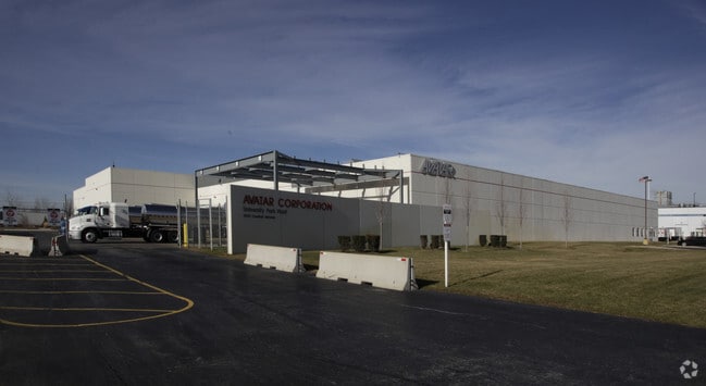
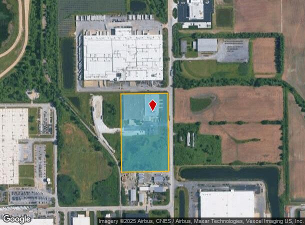
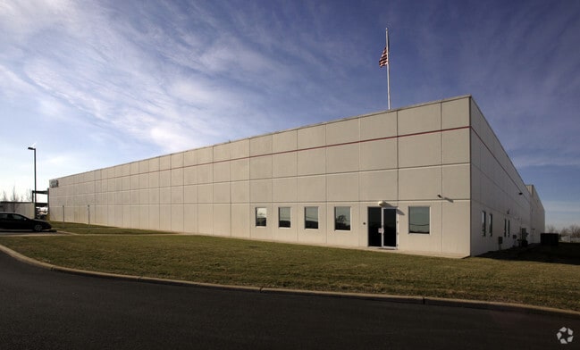
Property Record
500 Central Ave, Monee, IL 60449
NEARBY LISTINGS FOR SALE OR LEASE
Property Detail
500 Central Ave
Chicago-Naperville-Elgin, IL-IN
Usaa Commerece Center Sub
21-14-08-200-010
THE S1/2 OF THE E1/2 OF THE NE1/4 OF SEC 8, T34N-R13E (EX THE W 719.20 FT THROF PER R78-046347) (EX THE S 395.33 FT OF THE S1
Industrialgeneral
Will
X
Illinois
17197C0353G
11.91 AC
2023
Far South Cook
2024
Chicago
883602
DEMOGRAPHICS near 500 Central Ave
1 Mile
3 Mile
5 Mile
2024 Total Population
55
19,725
78,311
2029 Population
55
19,440
77,345
Pop Growth 2024-2029
0.00%
(1.44%)
(1.23%)
Average Age
41
41
41
2024 Total Households
20
7,610
29,558
HH Growth 2024-2029
0.00%
(1.64%)
(1.58%)
Median Household Inc
$93,749
$72,355
$71,132
Avg Household Size
2.60
2.50
2.60
2024 Avg HH Vehicles
2.00
2.00
2.00
Median Home Value
$250,000
$186,841
$170,205
Median Year Built
2003
1984
1977
Nearby Places
Map Layers
Map Styles
 Street
 Aerial
- Restaurants
- Banks
- Shops
- Fitness
- Groceries
PUBLIC TRANSPORTATION
COMMUTER RAIL
University Park Station (Metra Electric Line - Northeast Illinois Regional Commuter Railroad (Metra))
DRIVE
WALK
Distance
University Park Station (Metra Electric Line - Northeast Illinois Regional Commuter Railroad (Metra))
5 min
1.9 mi
Richton Park Station (Metra Electric Line - Northeast Illinois Regional Commuter Railroad (Metra))
DRIVE
WALK
Distance
Richton Park Station (Metra Electric Line - Northeast Illinois Regional Commuter Railroad (Metra))
8 min
3.9 mi
AIRPORT
Chicago Midway International
DRIVE
WALK
Distance
Chicago Midway International
40 min
25.1 mi
Nearby Properties
Address
Land Use
TOTAL SIZE
Lot Size
Zoning
Address
Land Use
TOTAL SIZE
Lot Size
Zoning
65.63 AC
Address
Land Use
TOTAL SIZE
Lot Size
Zoning
757,504 SF
46.30 AC
Address
Land Use
TOTAL SIZE
Lot Size
Zoning
990,000 SF
54.35 AC
Address
Land Use
TOTAL SIZE
Lot Size
Zoning
85.56 AC
Address
Land Use
TOTAL SIZE
Lot Size
Zoning
913,500 SF
54.87 AC
Address
Land Use
TOTAL SIZE
Lot Size
Zoning
575,024 SF
39.03 AC
Address
Land Use
TOTAL SIZE
Lot Size
Zoning
497,420 SF
35 AC
Address
Land Use
TOTAL SIZE
Lot Size
Zoning
718,777 SF
34.59 AC
Address
Land Use
TOTAL SIZE
Lot Size
Zoning
10.16 AC
Address
Land Use
TOTAL SIZE
Lot Size
Zoning
49.75 AC
Address
Land Use
TOTAL SIZE
Lot Size
Zoning
699,960 SF
31.34 AC
Address
Land Use
TOTAL SIZE
Lot Size
Zoning
650,160 SF
35.39 AC
Address
Land Use
TOTAL SIZE
Lot Size
Zoning
60.19 AC
Address
Land Use
TOTAL SIZE
Lot Size
Zoning
192,701 SF
31.69 AC
Address
Land Use
TOTAL SIZE
Lot Size
Zoning
11.02 AC
Address
Land Use
TOTAL SIZE
Lot Size
Zoning
431,600 SF
23.98 AC
Address
Land Use
TOTAL SIZE
Lot Size
Zoning
715,732 SF
33.76 AC
Address
Land Use
TOTAL SIZE
Lot Size
Zoning
455,870 SF
23.32 AC
Address
Land Use
TOTAL SIZE
Lot Size
Zoning
458,858 SF
36.97 AC
Address
Land Use
TOTAL SIZE
Lot Size
Zoning
14,000 SF
12.99 AC
Address
Land Use
TOTAL SIZE
Lot Size
Zoning
Address
Land Use
TOTAL SIZE
Lot Size
Zoning
12.36 AC
Address
Land Use
TOTAL SIZE
Lot Size
Zoning
72,668 SF
3 AC
Address
Land Use
TOTAL SIZE
Lot Size
Zoning
Address
Land Use
TOTAL SIZE
Lot Size
Zoning
142.91 AC
Address
Land Use
TOTAL SIZE
Lot Size
Zoning
70.02 AC
Address
Land Use
TOTAL SIZE
Lot Size
Zoning
192,369 SF
22.05 AC
Address
Land Use
TOTAL SIZE
Lot Size
Zoning
322,629 SF
53.73 AC
Address
Land Use
TOTAL SIZE
Lot Size
Zoning
8,920 SF
38.44 AC
Address
Land Use
TOTAL SIZE
Lot Size
Zoning
100,202 SF
2.90 AC
The World's #1 Commercial Real Estate Marketplace
Connect with us
© 2026 CoStar Group
The information above has been obtained from sources believed reliable. While we do not doubt its accuracy we have not verified it and make no guarantee, warranty or representation about it. It is your responsibility to independently confirm its accuracy and completeness. Any projections, opinions, assumptions, or estimates used are for example only and do not represent the current or future performance of the property. The value of this transaction to you depends on tax and other factors which should be evaluated by your tax, financial, and legal advisors. You and your advisors should conduct a careful, independent investigation of the property to determine to your satisfaction the suitability of the property for your needs.