Property Record
500 Cirby Way, Roseville, CA 95678
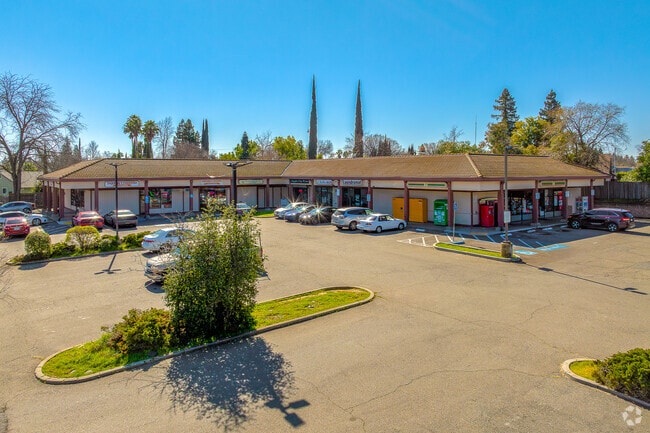


This Property Is For Sale
NEARBY LISTINGS FOR SALE OR LEASE
Property Detail
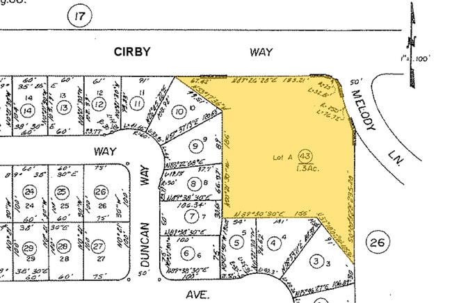
500 Cirby Way
Sacramento-Roseville-Folsom, CA
Rosedale
472-270-044
1.3 AC POR LOT A ROSEDALE MOR L-66
Storemultistory
Placer
X
California
06061C1031H
a,66
2024
1.30 AC
2025
Roseville/Rocklin
020805
Sacramento
13,500 SF
DEMOGRAPHICS near 500 Cirby Way
1 Mile
3 Mile
5 Mile
2024 Total Population
13,322
117,849
341,160
2029 Population
13,975
121,953
352,499
Pop Growth 2024-2029
+ 4.90%
+ 3.48%
+ 3.32%
Average Age
40
41
40
2024 Total Households
5,251
44,333
126,883
HH Growth 2024-2029
+ 4.93%
+ 3.62%
+ 3.41%
Median Household Inc
$70,925
$82,460
$87,361
Avg Household Size
2.50
2.60
2.60
2024 Avg HH Vehicles
2.00
2.00
2.00
Median Home Value
$384,186
$447,255
$470,428
Median Year Built
1977
1980
1984
Nearby Places
Map Layers
Map Styles
 Street
 Aerial
- Restaurants
- Banks
- Shops
- Fitness
- Groceries
PUBLIC TRANSPORTATION
COMMUTER RAIL
Roseville (California Zephyr - Amtrak, Capitol Corridor - Amtrak)
DRIVE
WALK
Distance
Roseville (California Zephyr - Amtrak, Capitol Corridor - Amtrak)
6 min
2.3 mi
Rocklin Amtrak Station (Capitol Corridor - Amtrak)
DRIVE
WALK
Distance
Rocklin Amtrak Station (Capitol Corridor - Amtrak)
10 min
6.4 mi
AIRPORT
Sacramento International
DRIVE
WALK
Distance
Sacramento International
31 min
23.1 mi
Freight Ports
Port of Stockton
DRIVE
WALK
Distance
Port of Stockton
73 min
63.3 mi
Nearby Properties
Address
Land Use
TOTAL SIZE
Lot Size
Zoning
Address
Land Use
TOTAL SIZE
Lot Size
Zoning
1,444,630 SF
53.20 AC
Address
Land Use
TOTAL SIZE
Lot Size
Zoning
277,602 SF
26.49 AC
Address
Land Use
TOTAL SIZE
Lot Size
Zoning
210,380 SF
14.26 AC
Address
Land Use
TOTAL SIZE
Lot Size
Zoning
263,682 SF
14.40 AC
Address
Land Use
TOTAL SIZE
Lot Size
Zoning
310,720 SF
16.90 AC
Address
Land Use
TOTAL SIZE
Lot Size
Zoning
78,730 SF
8.03 AC
RD20 BP
Address
Land Use
TOTAL SIZE
Lot Size
Zoning
128,480 SF
7.95 AC
RD30 BP
Address
Land Use
TOTAL SIZE
Lot Size
Zoning
217,550 SF
21.31 AC
SPA
Address
Land Use
TOTAL SIZE
Lot Size
Zoning
2,080 SF
136.17 AC
FDR
Address
Land Use
TOTAL SIZE
Lot Size
Zoning
126,521 SF
11 AC
Address
Land Use
TOTAL SIZE
Lot Size
Zoning
110,744 SF
6.70 AC
Address
Land Use
TOTAL SIZE
Lot Size
Zoning
148,663 SF
13.19 AC
SPA
Address
Land Use
TOTAL SIZE
Lot Size
Zoning
98,508 SF
5.33 AC
RD20
Address
Land Use
TOTAL SIZE
Lot Size
Zoning
109,098 SF
5.50 AC
Address
Land Use
TOTAL SIZE
Lot Size
Zoning
153,746 SF
15.20 AC
Address
Land Use
TOTAL SIZE
Lot Size
Zoning
111,185 SF
8.10 AC
Address
Land Use
TOTAL SIZE
Lot Size
Zoning
162,401 SF
5.29 AC
Address
Land Use
TOTAL SIZE
Lot Size
Zoning
140,237 SF
8.60 AC
Address
Land Use
TOTAL SIZE
Lot Size
Zoning
254,982 SF
19.60 AC
Address
Land Use
TOTAL SIZE
Lot Size
Zoning
268,502 SF
12.38 AC
RD30
Address
Land Use
TOTAL SIZE
Lot Size
Zoning
220,691 SF
18.28 AC
RD20
Address
Land Use
TOTAL SIZE
Lot Size
Zoning
141,279 SF
11.56 AC
SPA
Address
Land Use
TOTAL SIZE
Lot Size
Zoning
185,640 SF
17.80 AC
Address
Land Use
TOTAL SIZE
Lot Size
Zoning
61,056 SF
4.50 AC
Address
Land Use
TOTAL SIZE
Lot Size
Zoning
117,032 SF
5.90 AC
Address
Land Use
TOTAL SIZE
Lot Size
Zoning
145,700 SF
9.30 AC
Address
Land Use
TOTAL SIZE
Lot Size
Zoning
147,606 SF
11.80 AC
Address
Land Use
TOTAL SIZE
Lot Size
Zoning
109,538 SF
5.10 AC
Address
Land Use
TOTAL SIZE
Lot Size
Zoning
100,099 SF
10.80 AC
Address
Land Use
TOTAL SIZE
Lot Size
Zoning
145,922 SF
11.90 AC
The World's #1 Commercial Real Estate Marketplace
Connect with us
© 2026 CoStar Group
The information above has been obtained from sources believed reliable. While we do not doubt its accuracy we have not verified it and make no guarantee, warranty or representation about it. It is your responsibility to independently confirm its accuracy and completeness. Any projections, opinions, assumptions, or estimates used are for example only and do not represent the current or future performance of the property. The value of this transaction to you depends on tax and other factors which should be evaluated by your tax, financial, and legal advisors. You and your advisors should conduct a careful, independent investigation of the property to determine to your satisfaction the suitability of the property for your needs.