Property Record
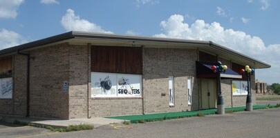
500 E Hastings Ave, Amarillo, TX 79108


NEARBY LISTINGS FOR SALE OR LEASE
Property Detail
500 E Hastings Ave
Amarillo, TX
Hamlet # 12
R-035-3480-2500-0
HAMLET # 12, LOT 001, BLK 0068
Bartavern
Potter
X
Texas
48375C0389C
001
2024
0.67 AC
2025
Amarillo
013900
Other Market Areas
5,092 SF
DEMOGRAPHICS near 500 E Hastings Ave
1 Mile
3 Mile
5 Mile
2024 Total Population
5,378
33,497
88,937
2029 Population
5,181
32,668
86,591
Pop Growth 2024-2029
(3.66%)
(2.47%)
(2.64%)
Average Age
35
34
36
2024 Total Households
1,879
11,512
32,681
HH Growth 2024-2029
(4.04%)
(2.72%)
(2.90%)
Median Household Inc
$39,351
$37,197
$43,170
Avg Household Size
2.70
2.80
2.60
2024 Avg HH Vehicles
2.00
2.00
2.00
Median Home Value
$65,914
$71,604
$91,838
Median Year Built
1958
1959
1958
Nearby Places
Map Layers
Map Styles
 Street
 Aerial
- Restaurants
- Banks
- Shops
- Fitness
- Groceries
PUBLIC TRANSPORTATION
AIRPORT
Rick Husband Amarillo International
DRIVE
WALK
Distance
Rick Husband Amarillo International
22 min
12.9 mi
Nearby Properties
Address
Land Use
TOTAL SIZE
Lot Size
Zoning
Address
Land Use
TOTAL SIZE
Lot Size
Zoning
350,459 SF
10.71 AC
Address
Land Use
TOTAL SIZE
Lot Size
Zoning
45,380 SF
2.62 AC
Address
Land Use
TOTAL SIZE
Lot Size
Zoning
325,727 SF
26.09 AC
2F
Address
Land Use
TOTAL SIZE
Lot Size
Zoning
133,279 SF
2.07 AC
CB
Address
Land Use
TOTAL SIZE
Lot Size
Zoning
80,476 SF
7.51 AC
I1
Address
Land Use
TOTAL SIZE
Lot Size
Zoning
388,909 SF
2.07 AC
CB
Address
Land Use
TOTAL SIZE
Lot Size
Zoning
193,004 SF
Address
Land Use
TOTAL SIZE
Lot Size
Zoning
132,820 SF
15.85 AC
R2
Address
Land Use
TOTAL SIZE
Lot Size
Zoning
64,847 SF
25.67 AC
R1
Address
Land Use
TOTAL SIZE
Lot Size
Zoning
128,891 SF
0.96 AC
CB
Address
Land Use
TOTAL SIZE
Lot Size
Zoning
288,936 SF
19.72 AC
MF1
Address
Land Use
TOTAL SIZE
Lot Size
Zoning
165,311 SF
2.07 AC
CB
Address
Land Use
TOTAL SIZE
Lot Size
Zoning
113,214 SF
8.24 AC
MF1
Address
Land Use
TOTAL SIZE
Lot Size
Zoning
68,117 SF
2.07 AC
CB
Address
Land Use
TOTAL SIZE
Lot Size
Zoning
39,430 SF
38.42 AC
Address
Land Use
TOTAL SIZE
Lot Size
Zoning
69,197 SF
617.85 AC
Address
Land Use
TOTAL SIZE
Lot Size
Zoning
70,537 SF
2.07 AC
Address
Land Use
TOTAL SIZE
Lot Size
Zoning
31,875 SF
2.07 AC
Address
Land Use
TOTAL SIZE
Lot Size
Zoning
37,134 SF
3.26 AC
Address
Land Use
TOTAL SIZE
Lot Size
Zoning
76,559 SF
3.87 AC
LC
Address
Land Use
TOTAL SIZE
Lot Size
Zoning
71,907 SF
8.54 AC
2F
Address
Land Use
TOTAL SIZE
Lot Size
Zoning
73,258 SF
7.58 AC
R2
Address
Land Use
TOTAL SIZE
Lot Size
Zoning
32,409 SF
1.40 AC
CB
Address
Land Use
TOTAL SIZE
Lot Size
Zoning
59,399 SF
10 AC
R2
Address
Land Use
TOTAL SIZE
Lot Size
Zoning
76,799 SF
29.97 AC
MF1
Address
Land Use
TOTAL SIZE
Lot Size
Zoning
58,977 SF
25.27 AC
PD
Address
Land Use
TOTAL SIZE
Lot Size
Zoning
64,496 SF
8.85 AC
Address
Land Use
TOTAL SIZE
Lot Size
Zoning
61,429 SF
12.81 AC
Address
Land Use
TOTAL SIZE
Lot Size
Zoning
201,990 SF
23.17 AC
MF1
Address
Land Use
TOTAL SIZE
Lot Size
Zoning
93,840 SF
4.82 AC
The World's #1 Commercial Real Estate Marketplace
Connect with us
© 2026 CoStar Group
The information above has been obtained from sources believed reliable. While we do not doubt its accuracy we have not verified it and make no guarantee, warranty or representation about it. It is your responsibility to independently confirm its accuracy and completeness. Any projections, opinions, assumptions, or estimates used are for example only and do not represent the current or future performance of the property. The value of this transaction to you depends on tax and other factors which should be evaluated by your tax, financial, and legal advisors. You and your advisors should conduct a careful, independent investigation of the property to determine to your satisfaction the suitability of the property for your needs.