Property Record
500 E Hatton Rd, Wichita Falls, TX 76302
Property Detail
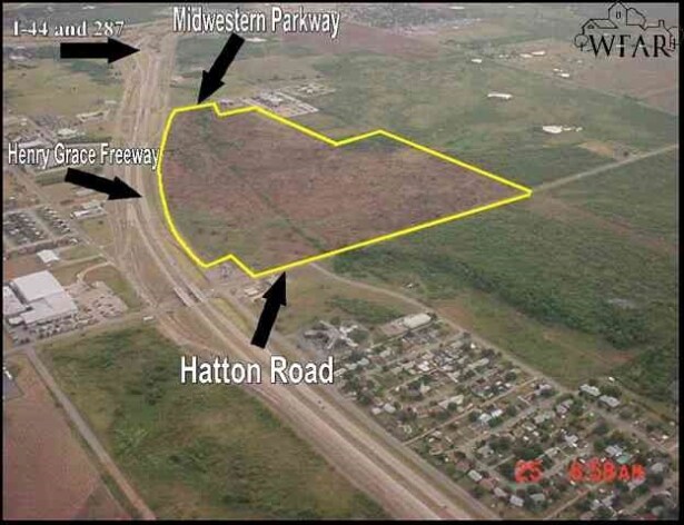
500 E Hatton Rd
Wichita Falls, TX
LOT 1 BLK 2 CTE ADDITION OUT OF BLK 6 KEMP & NEWBY CCSL
341276
Wichita
Privateschool
Texas
AE The base floodplain where base flood elevations are provided. AE Zones are now used on new format FIRMs instead of A1-A30 Zones.
1
0
21.85 AC
2025
Southwest Wichita Falls
011600
Other Market Areas
132,937 SF
NEARBY LISTINGS FOR SALE OR LEASE
DEMOGRAPHICS near 500 E Hatton Rd
1 mile
3 mile
5 mile
2025 Total Population
3,161
37,033
68,996
2030 Population
3,094
36,768
68,634
Pop Growth 2025-2030
(2.12%)
(0.72%)
(0.52%)
Average Age
39
38
39
2025 Total Households
1,210
14,984
28,094
HH Growth 2025-2030
(2.40%)
(0.97%)
(0.73%)
Median Household Inc
$65,129
$53,631
$57,993
Avg Household Size
2.40
2.20
2.30
2025 Avg HH Vehicles
2.00
2.00
2.00
Median Home Value
$112,882
$150,989
$163,312
Median Year Built
1972
1967
1967
Nearby Places
Map Layers
Map Styles
 Street
 Aerial
Layers
 Traffic
 Biking
Places
Listings with unknown addresses are not visible on the map
- Restaurants
- Banks
- Shops
- Fitness
- Groceries
Nearby Properties
Address
Land Use
TOTAL SIZE
Lot Size
Zoning
Address
Land Use
TOTAL SIZE
Lot Size
Zoning
1,172,641 SF
100 AC
Address
Land Use
TOTAL SIZE
Lot Size
Zoning
400,968 SF
123.30 AC
Address
Land Use
TOTAL SIZE
Lot Size
Zoning
164,255 SF
5.23 AC
Address
Land Use
TOTAL SIZE
Lot Size
Zoning
398,646 SF
7.51 AC
GC
Address
Land Use
TOTAL SIZE
Lot Size
Zoning
245,152 SF
5.12 AC
GC
Address
Land Use
TOTAL SIZE
Lot Size
Zoning
247,406 SF
10 AC
Address
Land Use
TOTAL SIZE
Lot Size
Zoning
356,863 SF
26.90 AC
HI
Address
Land Use
TOTAL SIZE
Lot Size
Zoning
157,968 SF
7.40 AC
GC
Address
Land Use
TOTAL SIZE
Lot Size
Zoning
24,741 SF
37.75 AC
Address
Land Use
TOTAL SIZE
Lot Size
Zoning
129,655 SF
Address
Land Use
TOTAL SIZE
Lot Size
Zoning
266,509 SF
14.25 AC
SF2
Address
Land Use
TOTAL SIZE
Lot Size
Zoning
130,756 SF
14.82 AC
Address
Land Use
TOTAL SIZE
Lot Size
Zoning
51,240 SF
3.46 AC
GC
Address
Land Use
TOTAL SIZE
Lot Size
Zoning
62,791 SF
63.60 AC
Address
Land Use
TOTAL SIZE
Lot Size
Zoning
151,854 SF
5.11 AC
Address
Land Use
TOTAL SIZE
Lot Size
Zoning
226,866 SF
12.10 AC
MFR
Address
Land Use
TOTAL SIZE
Lot Size
Zoning
69,483 SF
30 AC
Address
Land Use
TOTAL SIZE
Lot Size
Zoning
82,217 SF
10.57 AC
SF2
Address
Land Use
TOTAL SIZE
Lot Size
Zoning
95,926 SF
1.21 AC
CBD
Address
Land Use
TOTAL SIZE
Lot Size
Zoning
82,761 SF
2.01 AC
GC
Address
Land Use
TOTAL SIZE
Lot Size
Zoning
62,292 SF
14.61 AC
Address
Land Use
TOTAL SIZE
Lot Size
Zoning
179,865 SF
11.46 AC
Address
Land Use
TOTAL SIZE
Lot Size
Zoning
107,872 SF
4.02 AC
LC
Address
Land Use
TOTAL SIZE
Lot Size
Zoning
188,646 SF
19.90 AC
GC
Address
Land Use
TOTAL SIZE
Lot Size
Zoning
140,976 SF
18.49 AC
Address
Land Use
TOTAL SIZE
Lot Size
Zoning
67,331 SF
15 AC
Address
Land Use
TOTAL SIZE
Lot Size
Zoning
131,969 SF
5.96 AC
Address
Land Use
TOTAL SIZE
Lot Size
Zoning
70,577 SF
8.22 AC
Address
Land Use
TOTAL SIZE
Lot Size
Zoning
218,698 SF
14.50 AC
The World's #1 Commercial Real Estate Marketplace
Connect with us
© 2026 CoStar Group
The information above has been obtained from sources believed reliable. While we do not doubt its accuracy we have not verified it and make no guarantee, warranty or representation about it. It is your responsibility to independently confirm its accuracy and completeness. Any projections, opinions, assumptions, or estimates used are for example only and do not represent the current or future performance of the property. The value of this transaction to you depends on tax and other factors which should be evaluated by your tax, financial, and legal advisors. You and your advisors should conduct a careful, independent investigation of the property to determine to your satisfaction the suitability of the property for your needs.