Property Record
500 E Hazelwood St, Princeton, TX 75407
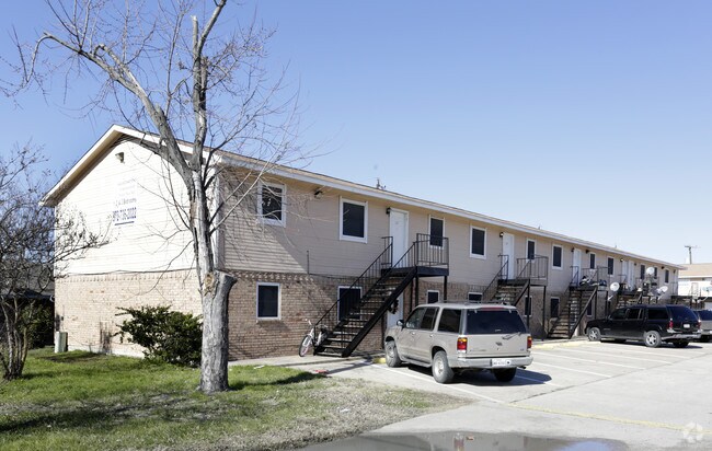

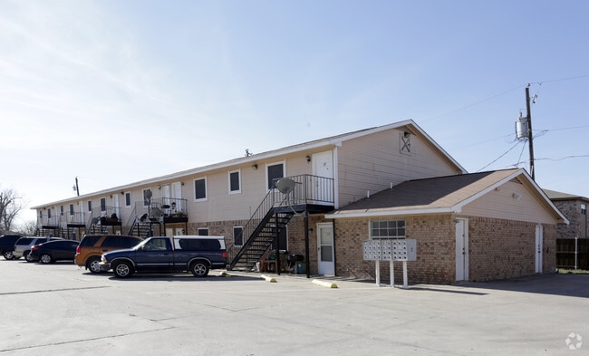
Property Detail
500 E Hazelwood St
R-6957-007-4200-1
ABS A0957 HARDIN WRIGHT SURVEY, SHEET 7, TRACT 420, 2.0 ACRES
Multifamilydwelling
Collin
MF2
Texas
B and X Area of moderate flood hazard, usually the area between the limits of the 100-year and 500-year floods.
420
2025
2 AC
2025
Princeton/NE Collin County
031006
Dallas/Ft Worth
27,150 SF
Dallas-Fort Worth-Arlington, TX
NEARBY LISTINGS FOR SALE OR LEASE
-
-
View all Princeton listings for sale on LoopNet.com
DEMOGRAPHICS near 500 E Hazelwood St
1 mile
3 mile
5 mile
2024 Total Population
7,982
36,115
47,678
2029 Population
9,568
43,080
56,822
Pop Growth 2024-2029
+ 19.87%
+ 19.29%
+ 19.18%
Average Age
36
36
36
2024 Total Households
2,616
11,580
15,342
HH Growth 2024-2029
+ 20.11%
+ 19.56%
+ 19.45%
Median Household Inc
$84,382
$92,504
$91,219
Avg Household Size
3.00
3.10
3.10
2024 Avg HH Vehicles
2.00
2.00
2.00
Median Home Value
$346,068
$364,606
$376,556
Median Year Built
2010
2010
2010
Nearby Places
Map Layers
Map Styles
 Street
 Aerial
Transit
 Traffic
 Biking
Places
Listings with unknown addresses are not visible on the map
- Restaurants
- Banks
- Shops
- Fitness
- Groceries
Nearby Properties
Address
Land Use
TOTAL SIZE
Lot Size
Zoning
Address
Land Use
TOTAL SIZE
Lot Size
Zoning
347,540 SF
12.05 AC
Address
Land Use
TOTAL SIZE
Lot Size
Zoning
223,314 SF
40.22 AC
Address
Land Use
TOTAL SIZE
Lot Size
Zoning
574,124 SF
71.45 AC
Address
Land Use
TOTAL SIZE
Lot Size
Zoning
300,249 SF
9.81 AC
PD
Address
Land Use
TOTAL SIZE
Lot Size
Zoning
143,934 SF
13.39 AC
Address
Land Use
TOTAL SIZE
Lot Size
Zoning
271,360 SF
51.35 AC
Address
Land Use
TOTAL SIZE
Lot Size
Zoning
173,085 SF
6.67 AC
Address
Land Use
TOTAL SIZE
Lot Size
Zoning
167,951 SF
7.99 AC
PD
Address
Land Use
TOTAL SIZE
Lot Size
Zoning
79,116 SF
13.09 AC
Address
Land Use
TOTAL SIZE
Lot Size
Zoning
189,543 SF
19.31 AC
COMM/RETAI
Address
Land Use
TOTAL SIZE
Lot Size
Zoning
100,426 SF
11.22 AC
Address
Land Use
TOTAL SIZE
Lot Size
Zoning
79,635 SF
9.06 AC
Address
Land Use
TOTAL SIZE
Lot Size
Zoning
1,053 SF
302.98 AC
PD
Address
Land Use
TOTAL SIZE
Lot Size
Zoning
176.12 AC
PD
Address
Land Use
TOTAL SIZE
Lot Size
Zoning
45,885 SF
14.65 AC
Address
Land Use
TOTAL SIZE
Lot Size
Zoning
51,743 SF
6 AC
Address
Land Use
TOTAL SIZE
Lot Size
Zoning
243,526 SF
11.12 AC
Address
Land Use
TOTAL SIZE
Lot Size
Zoning
64,844 SF
4.78 AC
B1
Address
Land Use
TOTAL SIZE
Lot Size
Zoning
268 SF
67.05 AC
Address
Land Use
TOTAL SIZE
Lot Size
Zoning
2,235 SF
24.53 AC
C
Address
Land Use
TOTAL SIZE
Lot Size
Zoning
80,794 SF
15.86 AC
Address
Land Use
TOTAL SIZE
Lot Size
Zoning
115,708 SF
17.50 AC
Address
Land Use
TOTAL SIZE
Lot Size
Zoning
1,592 SF
90.49 AC
Address
Land Use
TOTAL SIZE
Lot Size
Zoning
142,500 SF
7.02 AC
COMM
Address
Land Use
TOTAL SIZE
Lot Size
Zoning
235.49 AC
PD
Address
Land Use
TOTAL SIZE
Lot Size
Zoning
21,600 SF
2.44 AC
Address
Land Use
TOTAL SIZE
Lot Size
Zoning
63,616 SF
7.30 AC
Address
Land Use
TOTAL SIZE
Lot Size
Zoning
25.81 AC
Address
Land Use
TOTAL SIZE
Lot Size
Zoning
67.34 AC
PD
Address
Land Use
TOTAL SIZE
Lot Size
Zoning
116.27 AC
The World's #1 Commercial Real Estate Marketplace
Connect with us
© 2026 CoStar Group
The information above has been obtained from sources believed reliable. While we do not doubt its accuracy we have not verified it and make no guarantee, warranty or representation about it. It is your responsibility to independently confirm its accuracy and completeness. Any projections, opinions, assumptions, or estimates used are for example only and do not represent the current or future performance of the property. The value of this transaction to you depends on tax and other factors which should be evaluated by your tax, financial, and legal advisors. You and your advisors should conduct a careful, independent investigation of the property to determine to your satisfaction the suitability of the property for your needs.