Property Record
500 Cardinal Dr, Taylors, SC 29687
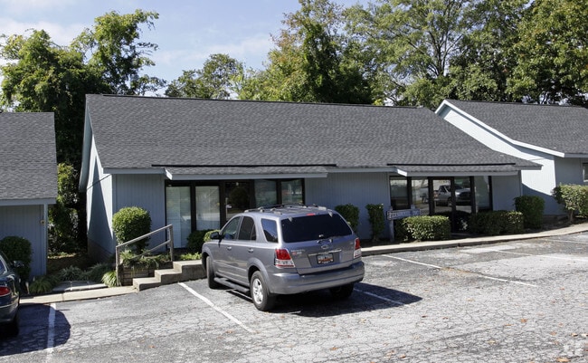


Property Detail
500 Cardinal Dr
Greenville-Anderson-Greer, SC
PT.10
P015.08-08-013.01
GREENVILLE
Officebuilding
South Carolina
OD
013.01
B and X Area of moderate flood hazard, usually the area between the limits of the 100-year and 500-year floods.
0.40 AC
2025
Greer/Taylors
2025
Greenville/Spartanburg
002610
NEARBY LISTINGS FOR SALE OR LEASE
DEMOGRAPHICS near 500 Cardinal Dr
1 mile
3 mile
5 mile
2025 Total Population
6,692
65,061
153,388
2030 Population
7,113
69,466
164,940
Pop Growth 2025-2030
+ 6.29%
+ 6.77%
+ 7.53%
Average Age
40
40
40
2025 Total Households
2,751
26,893
64,269
HH Growth 2025-2030
+ 6.54%
+ 6.98%
+ 7.85%
Median Household Inc
$66,270
$77,172
$79,083
Avg Household Size
2.40
2.30
2.30
2025 Avg HH Vehicles
2.00
2.00
2.00
Median Home Value
$221,350
$321,597
$355,836
Median Year Built
1968
1979
1985
Nearby Places
Map Layers
Map Styles
 Street
 Aerial
Layers
 Traffic
 Biking
Places
Listings with unknown addresses are not visible on the map
- Restaurants
- Banks
- Shops
- Fitness
- Groceries
PUBLIC TRANSPORTATION
COMMUTER RAIL
Drive
Walk
Distance
12 min
6.0 mi
AIRPORT
Greenville Spartanburg International
Drive
Walk
Distance
Greenville Spartanburg International
16 min
8.1 mi
Nearby Properties
Address
Land Use
TOTAL SIZE
Lot Size
Zoning
Address
Land Use
TOTAL SIZE
Lot Size
Zoning
97.93 AC
OD
Address
Land Use
TOTAL SIZE
Lot Size
Zoning
11.82 AC
RM2
Address
Land Use
TOTAL SIZE
Lot Size
Zoning
9.13 AC
RM2
Address
Land Use
TOTAL SIZE
Lot Size
Zoning
8.94 AC
RM2
Address
Land Use
TOTAL SIZE
Lot Size
Zoning
10 AC
RM
Address
Land Use
TOTAL SIZE
Lot Size
Zoning
6.91 AC
RM
Address
Land Use
TOTAL SIZE
Lot Size
Zoning
10.59 AC
RM2
Address
Land Use
TOTAL SIZE
Lot Size
Zoning
12 AC
RM
Address
Land Use
TOTAL SIZE
Lot Size
Zoning
5.61 AC
RM2
Address
Land Use
TOTAL SIZE
Lot Size
Zoning
26.30 AC
R20
Address
Land Use
TOTAL SIZE
Lot Size
Zoning
11.80 AC
R10
Address
Land Use
TOTAL SIZE
Lot Size
Zoning
11.30 AC
R10
Address
Land Use
TOTAL SIZE
Lot Size
Zoning
85.24 AC
C2,R12
Address
Land Use
TOTAL SIZE
Lot Size
Zoning
4.95 AC
C1
Address
Land Use
TOTAL SIZE
Lot Size
Zoning
19.31 AC
R6
Address
Land Use
TOTAL SIZE
Lot Size
Zoning
7.35 AC
C3
Address
Land Use
TOTAL SIZE
Lot Size
Zoning
4.20 AC
C2
Address
Land Use
TOTAL SIZE
Lot Size
Zoning
5.79 AC
C2
Address
Land Use
TOTAL SIZE
Lot Size
Zoning
0.92 AC
C2
Address
Land Use
TOTAL SIZE
Lot Size
Zoning
8.95 AC
OD
Address
Land Use
TOTAL SIZE
Lot Size
Zoning
3.11 AC
S1
Address
Land Use
TOTAL SIZE
Lot Size
Zoning
3,247 SF
15.64 AC
R6
Address
Land Use
TOTAL SIZE
Lot Size
Zoning
58.81 AC
R15
Address
Land Use
TOTAL SIZE
Lot Size
Zoning
41.90 AC
RMA
Address
Land Use
TOTAL SIZE
Lot Size
Zoning
3.70 AC
C2
Address
Land Use
TOTAL SIZE
Lot Size
Zoning
9.14 AC
R75
Address
Land Use
TOTAL SIZE
Lot Size
Zoning
3.10 AC
I1
Address
Land Use
TOTAL SIZE
Lot Size
Zoning
25.67 AC
R12
Address
Land Use
TOTAL SIZE
Lot Size
Zoning
12.30 AC
I1
Address
Land Use
TOTAL SIZE
Lot Size
Zoning
24.30 AC
PD
The World's #1 Commercial Real Estate Marketplace
Connect with us
© 2026 CoStar Group
The information above has been obtained from sources believed reliable. While we do not doubt its accuracy we have not verified it and make no guarantee, warranty or representation about it. It is your responsibility to independently confirm its accuracy and completeness. Any projections, opinions, assumptions, or estimates used are for example only and do not represent the current or future performance of the property. The value of this transaction to you depends on tax and other factors which should be evaluated by your tax, financial, and legal advisors. You and your advisors should conduct a careful, independent investigation of the property to determine to your satisfaction the suitability of the property for your needs.