Property Record
500 E Main St, Rockton, IL 61072


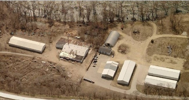
Property Detail
500 E Main St
Rockford, IL
JOHNSTON PETERSON SUB PT NE1/4 SEC 24-46-1 (EXC COMM SW COR LT 1 TH N 41.78FT TO POB TH NE 20.17 FT N 140 FT W 20FT TH S 142.62 FT TO POB) LT 1
03-24-276-016
Winnebago
Commercialacreage
Illinois
AE The base floodplain where base flood elevations are provided. AE Zones are now used on new format FIRMs instead of A1-A30 Zones.
1
2024
3 AC
2024
I-39 Cor/Winnebago Cy
004002
Chicago
NEARBY LISTINGS FOR SALE OR LEASE
-
-
View all Rockton listings for sale on LoopNet.com
DEMOGRAPHICS near 500 E Main St
1 mile
3 mile
5 mile
2025 Total Population
4,912
20,744
59,960
2030 Population
4,868
20,703
60,318
Pop Growth 2025-2030
(0.90%)
(0.20%)
+ 0.60%
Average Age
43
40
39
2025 Total Households
2,013
7,975
22,566
HH Growth 2025-2030
(0.94%)
(0.16%)
+ 0.62%
Median Household Inc
$76,587
$88,343
$74,428
Avg Household Size
2.40
2.60
2.60
2025 Avg HH Vehicles
2.00
2.00
2.00
Median Home Value
$203,120
$194,088
$189,403
Median Year Built
1983
1988
1976
Nearby Places
Map Layers
Map Styles
 Street
 Aerial
Layers
 Traffic
 Biking
Places
Listings with unknown addresses are not visible on the map
- Restaurants
- Banks
- Shops
- Fitness
- Groceries
PUBLIC TRANSPORTATION
AIRPORT
Chicago/Rockford International
Drive
Walk
Distance
Chicago/Rockford International
41 min
22.0 mi
Freight Ports
Port Milwaukee
Drive
Walk
Distance
Port Milwaukee
96 min
79.6 mi
SALE & LEASE HISTORY
LISTING DATE
SALE/LEASE

Sep 24, 2016
For Sale
Nearby Properties
Address
Land Use
TOTAL SIZE
Lot Size
Zoning
Address
Land Use
TOTAL SIZE
Lot Size
Zoning
33.53 AC
Address
Land Use
TOTAL SIZE
Lot Size
Zoning
121.46 AC
Address
Land Use
TOTAL SIZE
Lot Size
Zoning
66.74 AC
Address
Land Use
TOTAL SIZE
Lot Size
Zoning
8 AC
CN - COMM
Address
Land Use
TOTAL SIZE
Lot Size
Zoning
Address
Land Use
TOTAL SIZE
Lot Size
Zoning
Address
Land Use
TOTAL SIZE
Lot Size
Zoning
82,123 SF
1 AC
Address
Land Use
TOTAL SIZE
Lot Size
Zoning
218,074 SF
39.93 AC
IG GENERAL
Address
Land Use
TOTAL SIZE
Lot Size
Zoning
150,668 SF
89.27 AC
Address
Land Use
TOTAL SIZE
Lot Size
Zoning
301,509 SF
10.27 AC
IG GENERAL
Address
Land Use
TOTAL SIZE
Lot Size
Zoning
21.80 AC
Address
Land Use
TOTAL SIZE
Lot Size
Zoning
Address
Land Use
TOTAL SIZE
Lot Size
Zoning
2.22 AC
Address
Land Use
TOTAL SIZE
Lot Size
Zoning
Address
Land Use
TOTAL SIZE
Lot Size
Zoning
3.07 AC
RM
Address
Land Use
TOTAL SIZE
Lot Size
Zoning
7.70 AC
IL LIGHT I
Address
Land Use
TOTAL SIZE
Lot Size
Zoning
29,795 SF
1 AC
Address
Land Use
TOTAL SIZE
Lot Size
Zoning
Address
Land Use
TOTAL SIZE
Lot Size
Zoning
Address
Land Use
TOTAL SIZE
Lot Size
Zoning
64,527 SF
4.25 AC
IL
Address
Land Use
TOTAL SIZE
Lot Size
Zoning
40,397 SF
2.39 AC
RM
Address
Land Use
TOTAL SIZE
Lot Size
Zoning
61,500 SF
5.36 AC
IL
Address
Land Use
TOTAL SIZE
Lot Size
Zoning
67,185 SF
4 AC
Address
Land Use
TOTAL SIZE
Lot Size
Zoning
86,261 SF
12.72 AC
Address
Land Use
TOTAL SIZE
Lot Size
Zoning
6,112 SF
2.41 AC
CR - COMM
Address
Land Use
TOTAL SIZE
Lot Size
Zoning
29,116 SF
3.47 AC
RM
Address
Land Use
TOTAL SIZE
Lot Size
Zoning
11.22 AC
IG
Address
Land Use
TOTAL SIZE
Lot Size
Zoning
49,212 SF
5.99 AC
Address
Land Use
TOTAL SIZE
Lot Size
Zoning
294,355 SF
53.53 AC
IG GENERAL
Address
Land Use
TOTAL SIZE
Lot Size
Zoning
The World's #1 Commercial Real Estate Marketplace
Connect with us
© 2026 CoStar Group
The information above has been obtained from sources believed reliable. While we do not doubt its accuracy we have not verified it and make no guarantee, warranty or representation about it. It is your responsibility to independently confirm its accuracy and completeness. Any projections, opinions, assumptions, or estimates used are for example only and do not represent the current or future performance of the property. The value of this transaction to you depends on tax and other factors which should be evaluated by your tax, financial, and legal advisors. You and your advisors should conduct a careful, independent investigation of the property to determine to your satisfaction the suitability of the property for your needs.