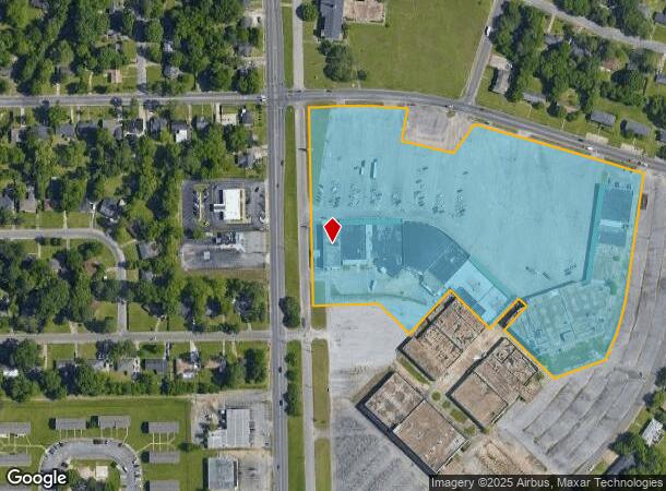
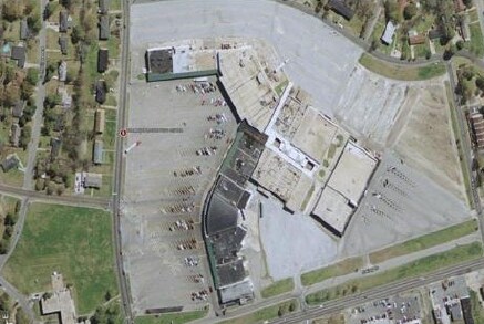
Property Record
500 E Patton Ave, Montgomery, AL 36111

NEARBY LISTINGS FOR SALE OR LEASE
Property Detail
500 E Patton Ave
10-09-30-4-013-001.002
SEC 30 T16N R18E 13.108 AC IN SE1/4 1009304013001002
Stripcommercialcenter
Montgomery
X
Alabama
01101C0208J
13.11 AC
2025
South Montgomery
2025
Montgomery
002100
Montgomery, AL
13,112 SF
DEMOGRAPHICS near 500 E Patton Ave
1 Mile
3 Mile
5 Mile
2024 Total Population
9,410
58,418
118,014
2029 Population
9,296
58,003
116,467
Pop Growth 2024-2029
(1.21%)
(0.71%)
(1.31%)
Average Age
39
39
38
2024 Total Households
3,634
23,489
48,427
HH Growth 2024-2029
(1.24%)
(0.53%)
(1.27%)
Median Household Inc
$40,793
$37,458
$36,839
Avg Household Size
2.50
2.30
2.30
2024 Avg HH Vehicles
2.00
2.00
2.00
Median Home Value
$83,823
$107,882
$113,172
Median Year Built
1958
1964
1971
Nearby Places
Map Layers
Map Styles
 Street
 Aerial
- Restaurants
- Banks
- Shops
- Fitness
- Groceries
PUBLIC TRANSPORTATION
AIRPORT
Montgomery Regional (Dannelly Field)
DRIVE
WALK
Distance
Montgomery Regional (Dannelly Field)
11 min
7.3 mi
SALE & LEASE HISTORY
LISTING DATE
SALE/LEASE

Sep 25, 2016
For Lease
Nearby Properties
Address
Land Use
TOTAL SIZE
Lot Size
Zoning
Address
Land Use
TOTAL SIZE
Lot Size
Zoning
150,842 SF
5.40 AC
T5
Address
Land Use
TOTAL SIZE
Lot Size
Zoning
260,402 SF
17 AC
O-2
Address
Land Use
TOTAL SIZE
Lot Size
Zoning
193,643 SF
1.61 AC
T5
Address
Land Use
TOTAL SIZE
Lot Size
Zoning
36,543 SF
0.62 AC
SD-M
Address
Land Use
TOTAL SIZE
Lot Size
Zoning
40,829 SF
50.49 AC
SD
Address
Land Use
TOTAL SIZE
Lot Size
Zoning
10,844 SF
1.63 AC
Address
Land Use
TOTAL SIZE
Lot Size
Zoning
93,981 SF
1.90 AC
T5
Address
Land Use
TOTAL SIZE
Lot Size
Zoning
32,902 SF
14 AC
R-75-M
Address
Land Use
TOTAL SIZE
Lot Size
Zoning
8,519 SF
15.60 AC
B-2
Address
Land Use
TOTAL SIZE
Lot Size
Zoning
91,378 SF
2.46 AC
SD-M
Address
Land Use
TOTAL SIZE
Lot Size
Zoning
341,170 SF
O-2
Address
Land Use
TOTAL SIZE
Lot Size
Zoning
38,226 SF
5.77 AC
T5
Address
Land Use
TOTAL SIZE
Lot Size
Zoning
1.72 AC
T5
Address
Land Use
TOTAL SIZE
Lot Size
Zoning
14,733 SF
19 AC
O-2
Address
Land Use
TOTAL SIZE
Lot Size
Zoning
249,231 SF
20 AC
INST
Address
Land Use
TOTAL SIZE
Lot Size
Zoning
135,573 SF
35 AC
O-2
Address
Land Use
TOTAL SIZE
Lot Size
Zoning
1,721 SF
12.02 AC
R-60-M
Address
Land Use
TOTAL SIZE
Lot Size
Zoning
3,401 SF
3.21 AC
T5
Address
Land Use
TOTAL SIZE
Lot Size
Zoning
128,328 SF
2.27 AC
T5
Address
Land Use
TOTAL SIZE
Lot Size
Zoning
1,904 SF
13 AC
R-75-S
Address
Land Use
TOTAL SIZE
Lot Size
Zoning
113,108 SF
3.70 AC
B-3
Address
Land Use
TOTAL SIZE
Lot Size
Zoning
65,060 SF
2.16 AC
T4-R
Address
Land Use
TOTAL SIZE
Lot Size
Zoning
145,385 SF
3.31 AC
T4-0
Address
Land Use
TOTAL SIZE
Lot Size
Zoning
61,137 SF
59 AC
INST
Address
Land Use
TOTAL SIZE
Lot Size
Zoning
57,565 SF
1.50 AC
T4-R
Address
Land Use
TOTAL SIZE
Lot Size
Zoning
95,886 SF
3.19 AC
B-4
Address
Land Use
TOTAL SIZE
Lot Size
Zoning
54,384 SF
0.65 AC
Address
Land Use
TOTAL SIZE
Lot Size
Zoning
8,652 SF
5.28 AC
R-75-D
Address
Land Use
TOTAL SIZE
Lot Size
Zoning
154,202 SF
14.90 AC
B-4
Address
Land Use
TOTAL SIZE
Lot Size
Zoning
91,241 SF
9.10 AC
R-65-S
The World's #1 Commercial Real Estate Marketplace
Connect with us
© 2025 CoStar Group
The information above has been obtained from sources believed reliable. While we do not doubt its accuracy we have not verified it and make no guarantee, warranty or representation about it. It is your responsibility to independently confirm its accuracy and completeness. Any projections, opinions, assumptions, or estimates used are for example only and do not represent the current or future performance of the property. The value of this transaction to you depends on tax and other factors which should be evaluated by your tax, financial, and legal advisors. You and your advisors should conduct a careful, independent investigation of the property to determine to your satisfaction the suitability of the property for your needs.