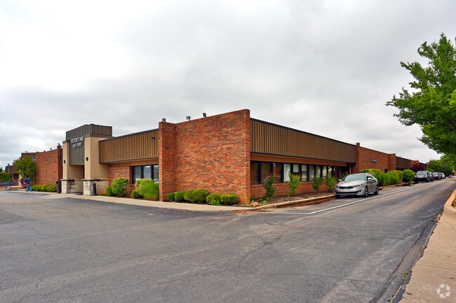
Property Record
500 E Robinson St, Norman, OK 73071


NEARBY LISTINGS FOR SALE OR LEASE
Property Detail
500 E Robinson St
Oklahoma City, OK
Doctors Park 2
R0031866
DOCTORS PARK 1 LOT 1 BLK 1
Officebuilding
Cleveland
X
Oklahoma
40027C0280J
1
2024
2.12 AC
2024
Norman
200200
Oklahoma City
39,419 SF
DEMOGRAPHICS near 500 E Robinson St
1 Mile
3 Mile
5 Mile
2024 Total Population
8,243
79,239
126,187
2029 Population
8,662
82,844
132,021
Pop Growth 2024-2029
+ 5.08%
+ 4.55%
+ 4.62%
Average Age
37
35
36
2024 Total Households
3,402
30,767
50,110
HH Growth 2024-2029
+ 5.38%
+ 5.00%
+ 4.94%
Median Household Inc
$44,905
$51,144
$57,540
Avg Household Size
2.30
2.20
2.30
2024 Avg HH Vehicles
2.00
2.00
2.00
Median Home Value
$134,764
$183,967
$219,166
Median Year Built
1966
1981
1988
Nearby Places
Map Layers
Map Styles
 Street
 Aerial
- Restaurants
- Banks
- Shops
- Fitness
- Groceries
PUBLIC TRANSPORTATION
COMMUTER RAIL
Norman Amtrak Station (Heartland Flyer - Amtrak)
DRIVE
WALK
Distance
Norman Amtrak Station (Heartland Flyer - Amtrak)
3 min
1.3 mi
AIRPORT
Will Rogers World
DRIVE
WALK
Distance
Will Rogers World
34 min
20.8 mi
Freight Ports
Tulsa Port Of Catoosa
DRIVE
WALK
Distance
Tulsa Port Of Catoosa
156 min
140.1 mi
SALE & LEASE HISTORY
LISTING DATE
SALE/LEASE

Sep 24, 2016
For Sale
Nearby Properties
Address
Land Use
TOTAL SIZE
Lot Size
Zoning
Address
Land Use
TOTAL SIZE
Lot Size
Zoning
18,644 SF
2.16 AC
CO
Address
Land Use
TOTAL SIZE
Lot Size
Zoning
44.21 AC
Address
Land Use
TOTAL SIZE
Lot Size
Zoning
3.75 AC
Address
Land Use
TOTAL SIZE
Lot Size
Zoning
Address
Land Use
TOTAL SIZE
Lot Size
Zoning
4.86 AC
Address
Land Use
TOTAL SIZE
Lot Size
Zoning
100,000 SF
208.35 AC
Address
Land Use
TOTAL SIZE
Lot Size
Zoning
191,169 SF
6.30 AC
I2
Address
Land Use
TOTAL SIZE
Lot Size
Zoning
2.57 AC
Address
Land Use
TOTAL SIZE
Lot Size
Zoning
60,000 SF
4.39 AC
RM
Address
Land Use
TOTAL SIZE
Lot Size
Zoning
17.11 AC
Address
Land Use
TOTAL SIZE
Lot Size
Zoning
0.86 AC
Address
Land Use
TOTAL SIZE
Lot Size
Zoning
7.28 AC
Address
Land Use
TOTAL SIZE
Lot Size
Zoning
Address
Land Use
TOTAL SIZE
Lot Size
Zoning
10.83 AC
R1
Address
Land Use
TOTAL SIZE
Lot Size
Zoning
319,555 SF
6.86 AC
Address
Land Use
TOTAL SIZE
Lot Size
Zoning
Address
Land Use
TOTAL SIZE
Lot Size
Zoning
3.09 AC
Address
Land Use
TOTAL SIZE
Lot Size
Zoning
7.20 AC
Address
Land Use
TOTAL SIZE
Lot Size
Zoning
174,742 SF
26.71 AC
Address
Land Use
TOTAL SIZE
Lot Size
Zoning
0.41 AC
R2
Address
Land Use
TOTAL SIZE
Lot Size
Zoning
5.22 AC
Address
Land Use
TOTAL SIZE
Lot Size
Zoning
345,756 SF
26.21 AC
Address
Land Use
TOTAL SIZE
Lot Size
Zoning
Address
Land Use
TOTAL SIZE
Lot Size
Zoning
32,789 SF
9.50 AC
I1
Address
Land Use
TOTAL SIZE
Lot Size
Zoning
292,511 SF
6.20 AC
Address
Land Use
TOTAL SIZE
Lot Size
Zoning
102,331 SF
12.46 AC
Address
Land Use
TOTAL SIZE
Lot Size
Zoning
36,922 SF
6.21 AC
Address
Land Use
TOTAL SIZE
Lot Size
Zoning
3.70 AC
Address
Land Use
TOTAL SIZE
Lot Size
Zoning
6.67 AC
Address
Land Use
TOTAL SIZE
Lot Size
Zoning
20,270 SF
1.17 AC
R1
The World's #1 Commercial Real Estate Marketplace
Connect with us
© 2025 CoStar Group
The information above has been obtained from sources believed reliable. While we do not doubt its accuracy we have not verified it and make no guarantee, warranty or representation about it. It is your responsibility to independently confirm its accuracy and completeness. Any projections, opinions, assumptions, or estimates used are for example only and do not represent the current or future performance of the property. The value of this transaction to you depends on tax and other factors which should be evaluated by your tax, financial, and legal advisors. You and your advisors should conduct a careful, independent investigation of the property to determine to your satisfaction the suitability of the property for your needs.