Property Record
500 Greenleaf Rd, Conyers, GA 30013
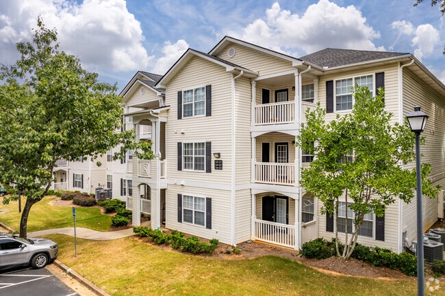


Property Detail
500 Greenleaf Rd
0012000000168000
25.082AC SUMMERSET APT
Clubslodgesprofessionalassociations
NEWTON
C1
Georgia
B and X Area of moderate flood hazard, usually the area between the limits of the 100-year and 500-year floods.
169
2025
25.08 AC
2025
Newton County
060312
Atlanta
1,648 SF
Atlanta-Sandy Springs-Roswell, GA
NEARBY LISTINGS FOR SALE OR LEASE
-
-
View all Conyers listings for sale on LoopNet.com
DEMOGRAPHICS near 500 Greenleaf Rd
1 mile
3 mile
5 mile
2025 Total Population
10,822
50,208
99,463
2030 Population
11,570
53,609
105,923
Pop Growth 2025-2030
+ 6.91%
+ 6.77%
+ 6.49%
Average Age
37
38
38
2025 Total Households
4,005
17,419
35,074
HH Growth 2025-2030
+ 7.09%
+ 6.93%
+ 6.64%
Median Household Inc
$63,743
$80,497
$76,403
Avg Household Size
2.70
2.80
2.80
2025 Avg HH Vehicles
2.00
2.00
2.00
Median Home Value
$296,125
$288,760
$275,832
Median Year Built
1996
1997
1994
Nearby Places
Map Layers
Map Styles
 Street
 Aerial
Layers
 Traffic
 Biking
Places
Listings with unknown addresses are not visible on the map
- Restaurants
- Banks
- Shops
- Fitness
- Groceries
PUBLIC TRANSPORTATION
AIRPORT
Hartsfield - Jackson Atlanta International
Drive
Walk
Distance
Hartsfield - Jackson Atlanta International
45 min
33.1 mi
Freight Ports
Georgia Ports - Savannah
Drive
Walk
Distance
Georgia Ports - Savannah
275 min
238.1 mi
Nearby Properties
Address
Land Use
TOTAL SIZE
Lot Size
Zoning
Address
Land Use
TOTAL SIZE
Lot Size
Zoning
4,734 SF
35.19 AC
RMF
Address
Land Use
TOTAL SIZE
Lot Size
Zoning
4,162 SF
37.52 AC
R3
Address
Land Use
TOTAL SIZE
Lot Size
Zoning
306,886 SF
118.50 AC
R2
Address
Land Use
TOTAL SIZE
Lot Size
Zoning
882,960 SF
0.01 AC
Address
Land Use
TOTAL SIZE
Lot Size
Zoning
324,975 SF
35.98 AC
M1
Address
Land Use
TOTAL SIZE
Lot Size
Zoning
135,000 SF
24.77 AC
M1
Address
Land Use
TOTAL SIZE
Lot Size
Zoning
175,605 SF
39.99 AC
AR
Address
Land Use
TOTAL SIZE
Lot Size
Zoning
33,216 SF
8.26 AC
MXD/CID/MU
Address
Land Use
TOTAL SIZE
Lot Size
Zoning
8,268 SF
46.94 AC
R3
Address
Land Use
TOTAL SIZE
Lot Size
Zoning
17,056 SF
16.78 AC
C1
Address
Land Use
TOTAL SIZE
Lot Size
Zoning
177,123 SF
9.63 AC
MXD/CID/MU
Address
Land Use
TOTAL SIZE
Lot Size
Zoning
131,111 SF
22.17 AC
R3
Address
Land Use
TOTAL SIZE
Lot Size
Zoning
372,762 SF
32.27 AC
A1
Address
Land Use
TOTAL SIZE
Lot Size
Zoning
163,807 SF
10.60 AC
M1
Address
Land Use
TOTAL SIZE
Lot Size
Zoning
5,160 SF
45.17 AC
C1
Address
Land Use
TOTAL SIZE
Lot Size
Zoning
28,472 SF
39.03 AC
OI
Address
Land Use
TOTAL SIZE
Lot Size
Zoning
882,960 SF
114.02 AC
M1
Address
Land Use
TOTAL SIZE
Lot Size
Zoning
154,980 SF
17.37 AC
M1
Address
Land Use
TOTAL SIZE
Lot Size
Zoning
8,156 SF
14.49 AC
C1
Address
Land Use
TOTAL SIZE
Lot Size
Zoning
8,832 SF
8.26 AC
C1
Address
Land Use
TOTAL SIZE
Lot Size
Zoning
8,632 SF
8.11 AC
C1
Address
Land Use
TOTAL SIZE
Lot Size
Zoning
42,540 SF
2.40 AC
MXD
Address
Land Use
TOTAL SIZE
Lot Size
Zoning
77,016 SF
15.28 AC
C2
Address
Land Use
TOTAL SIZE
Lot Size
Zoning
115,823 SF
14.20 AC
M1
Address
Land Use
TOTAL SIZE
Lot Size
Zoning
125,971 SF
23.84 AC
C1
Address
Land Use
TOTAL SIZE
Lot Size
Zoning
130,000 SF
33.48 AC
R1
Address
Land Use
TOTAL SIZE
Lot Size
Zoning
65,360 SF
75.51 AC
E6
Address
Land Use
TOTAL SIZE
Lot Size
Zoning
65,520 SF
35 AC
E6
Address
Land Use
TOTAL SIZE
Lot Size
Zoning
65,008 SF
23.81 AC
R2
The World's #1 Commercial Real Estate Marketplace
Connect with us
© 2026 CoStar Group
The information above has been obtained from sources believed reliable. While we do not doubt its accuracy we have not verified it and make no guarantee, warranty or representation about it. It is your responsibility to independently confirm its accuracy and completeness. Any projections, opinions, assumptions, or estimates used are for example only and do not represent the current or future performance of the property. The value of this transaction to you depends on tax and other factors which should be evaluated by your tax, financial, and legal advisors. You and your advisors should conduct a careful, independent investigation of the property to determine to your satisfaction the suitability of the property for your needs.