Property Record
500 Grumman Rd W, Bethpage, NY 11714
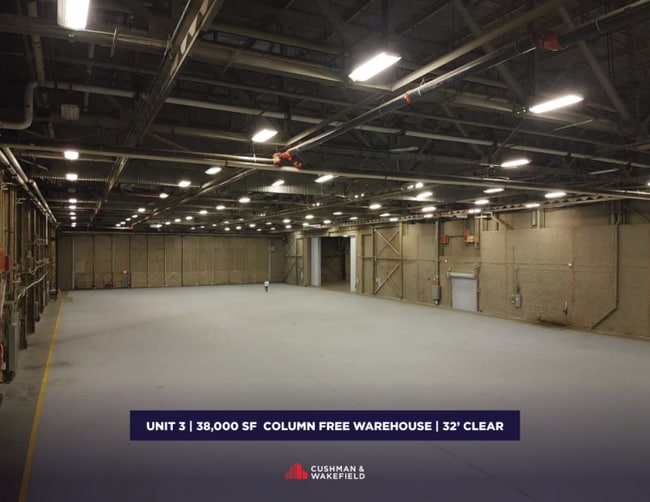
Current Lease Availabilities
NEARBY LISTINGS FOR SALE OR LEASE
Property Detail
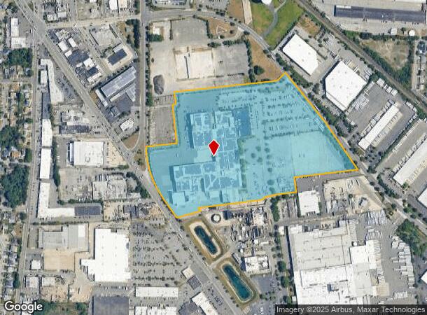
500 Grumman Rd W
Nassau County-Suffolk County, NY
Lunar Module Park
2489-46-323-00-0291-UCA023900001
291 CA 239 UNIT 1
Officecondo
Nassau
X
New York
36103C0830H
291
0
29.49 AC
2025
Eastern Nassau
520001
Long Island (New York)
DEMOGRAPHICS near 500 Grumman Rd W
1 Mile
3 Mile
5 Mile
2024 Total Population
16,644
166,138
378,994
2029 Population
16,367
163,074
372,342
Pop Growth 2024-2029
(1.66%)
(1.84%)
(1.76%)
Average Age
44
42
42
2024 Total Households
5,623
53,459
123,143
HH Growth 2024-2029
(1.48%)
(1.95%)
(1.85%)
Median Household Inc
$116,400
$131,920
$133,557
Avg Household Size
2.90
3.00
2.90
2024 Avg HH Vehicles
2.00
2.00
2.00
Median Home Value
$594,622
$610,327
$640,977
Median Year Built
1955
1954
1956
Nearby Places
- Restaurants
- Banks
- Shops
- Fitness
- Groceries
PUBLIC TRANSPORTATION
COMMUTER RAIL
Bethpage Station (Ronkonkoma Branch - Long Island Rail Road)
DRIVE
WALK
Distance
Bethpage Station (Ronkonkoma Branch - Long Island Rail Road)
8 min
1.5 mi
Hicksville Station (Montauk Branch - Long Island Rail Road, Port Jefferson Branch - Long Island Rail Road, Ronkonkoma Branch - Long Island Rail Road)
DRIVE
WALK
Distance
Hicksville Station (Montauk Branch - Long Island Rail Road, Port Jefferson Branch - Long Island Rail Road, Ronkonkoma Branch - Long Island Rail Road)
7 min
2.8 mi
AIRPORT
John F Kennedy International
DRIVE
WALK
Distance
John F Kennedy International
37 min
22.9 mi
LaGuardia
DRIVE
WALK
Distance
LaGuardia
40 min
24.6 mi
Long Island MacArthur
DRIVE
WALK
Distance
Long Island MacArthur
42 min
27.2 mi
Freight Ports
NY - Red Hook Container Terminal
DRIVE
WALK
Distance
NY - Red Hook Container Terminal
51 min
32.7 mi
Nearby Properties
Address
Land Use
TOTAL SIZE
Lot Size
Zoning
Address
Land Use
TOTAL SIZE
Lot Size
Zoning
170,920 SF
27.82 AC
Address
Land Use
TOTAL SIZE
Lot Size
Zoning
116,514 SF
382 AC
Address
Land Use
TOTAL SIZE
Lot Size
Zoning
35,978 SF
375.68 AC
Address
Land Use
TOTAL SIZE
Lot Size
Zoning
1,945 SF
278.09 AC
Address
Land Use
TOTAL SIZE
Lot Size
Zoning
1,003,826 SF
84.27 AC
Address
Land Use
TOTAL SIZE
Lot Size
Zoning
15,825 SF
22.94 AC
Address
Land Use
TOTAL SIZE
Lot Size
Zoning
288 SF
194.85 AC
Address
Land Use
TOTAL SIZE
Lot Size
Zoning
659,098 SF
34.76 AC
Address
Land Use
TOTAL SIZE
Lot Size
Zoning
384,267 SF
29.25 AC
Address
Land Use
TOTAL SIZE
Lot Size
Zoning
3,951 SF
44.33 AC
Address
Land Use
TOTAL SIZE
Lot Size
Zoning
1,068,978 SF
56.12 AC
Address
Land Use
TOTAL SIZE
Lot Size
Zoning
348,954 SF
9.98 AC
Address
Land Use
TOTAL SIZE
Lot Size
Zoning
52,750 SF
55.67 AC
Address
Land Use
TOTAL SIZE
Lot Size
Zoning
8,000 SF
17.75 AC
Address
Land Use
TOTAL SIZE
Lot Size
Zoning
505,020 SF
58.54 AC
Address
Land Use
TOTAL SIZE
Lot Size
Zoning
332,290 SF
25.91 AC
Address
Land Use
TOTAL SIZE
Lot Size
Zoning
331,084 SF
26.95 AC
Address
Land Use
TOTAL SIZE
Lot Size
Zoning
144,358 SF
21.73 AC
Address
Land Use
TOTAL SIZE
Lot Size
Zoning
177,845 SF
22.04 AC
Address
Land Use
TOTAL SIZE
Lot Size
Zoning
66,602 SF
19.93 AC
Address
Land Use
TOTAL SIZE
Lot Size
Zoning
12,261 SF
12.83 AC
Address
Land Use
TOTAL SIZE
Lot Size
Zoning
60,571 SF
127.50 AC
Address
Land Use
TOTAL SIZE
Lot Size
Zoning
34,500 SF
16 AC
Address
Land Use
TOTAL SIZE
Lot Size
Zoning
84,714 SF
15.09 AC
Address
Land Use
TOTAL SIZE
Lot Size
Zoning
28,392 SF
16.58 AC
Address
Land Use
TOTAL SIZE
Lot Size
Zoning
992,672 SF
37.18 AC
Address
Land Use
TOTAL SIZE
Lot Size
Zoning
219,370 SF
15.31 AC
Address
Land Use
TOTAL SIZE
Lot Size
Zoning
177,109 SF
23.78 AC
Address
Land Use
TOTAL SIZE
Lot Size
Zoning
228,527 SF
4.81 AC
Address
Land Use
TOTAL SIZE
Lot Size
Zoning
348,861 SF
2.22 AC
The World's #1 Commercial Real Estate Marketplace
Connect with us
© 2025 CoStar Group
The information above has been obtained from sources believed reliable. While we do not doubt its accuracy we have not verified it and make no guarantee, warranty or representation about it. It is your responsibility to independently confirm its accuracy and completeness. Any projections, opinions, assumptions, or estimates used are for example only and do not represent the current or future performance of the property. The value of this transaction to you depends on tax and other factors which should be evaluated by your tax, financial, and legal advisors. You and your advisors should conduct a careful, independent investigation of the property to determine to your satisfaction the suitability of the property for your needs.