Property Record
500 Interlocken Blvd, Broomfield, CO 80021


Save to a Folder
{{folder.Name}}
{{folder.ListingIds.length}} Properties
{{folder.ListingIds.length}} Property
Create a New Folder
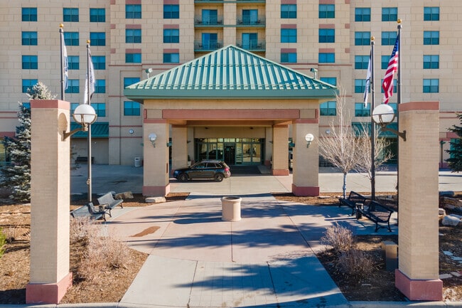
Property Detail
500 Interlocken Blvd
1575-33-1-10-001
SUBD: INTERLOCKEN FILING NO 4 LOT: 1 BLOCK: 1 AND ~0.299 AC PER COALTON ROAD ROW VACATION RECPT NO 2007005498
Hotel
Broomfield
PUD
Colorado
B and X Area of moderate flood hazard, usually the area between the limits of the 100-year and 500-year floods.
1
2025
18.60 AC
2026
Denver North
031104
Denver
320,771 SF
Denver-Aurora-Centennial, CO
NEARBY LISTINGS FOR SALE OR LEASE
-
-
View all Broomfield listings for sale on LoopNet.com
DEMOGRAPHICS near 500 Interlocken Blvd
1 mile
3 mile
5 mile
2025 Total Population
3,364
49,513
152,876
2030 Population
3,618
50,801
154,939
Pop Growth 2025-2030
+ 7.55%
+ 2.60%
+ 1.35%
Average Age
37
39
40
2025 Total Households
1,834
21,583
61,770
HH Growth 2025-2030
+ 8.34%
+ 3.33%
+ 1.66%
Median Household Inc
$100,218
$107,829
$116,329
Avg Household Size
1.80
2.30
2.40
2025 Avg HH Vehicles
2.00
2.00
2.00
Median Home Value
$615,466
$703,960
$708,536
Median Year Built
2010
1998
1993
Nearby Places
Map Layers
Map Styles
 Street
 Aerial
Layers
 Traffic
 Biking
Places
Listings with unknown addresses are not visible on the map
- Restaurants
- Banks
- Shops
- Fitness
- Groceries
PUBLIC TRANSPORTATION
AIRPORT
Denver International
Drive
Walk
Distance
Denver International
39 min
34.4 mi
Freight Ports
Tulsa Port Of Catoosa
Drive
Walk
Distance
Tulsa Port Of Catoosa
742 min
720.5 mi
Nearby Properties
Address
Land Use
TOTAL SIZE
Lot Size
Zoning
Address
Land Use
TOTAL SIZE
Lot Size
Zoning
776,625 SF
41.29 AC
PUD
Address
Land Use
TOTAL SIZE
Lot Size
Zoning
420,330 SF
41.96 AC
A
Address
Land Use
TOTAL SIZE
Lot Size
Zoning
419,866 SF
17.63 AC
Address
Land Use
TOTAL SIZE
Lot Size
Zoning
305,331 SF
14.41 AC
PUD
Address
Land Use
TOTAL SIZE
Lot Size
Zoning
57.62 AC
Address
Land Use
TOTAL SIZE
Lot Size
Zoning
211,191 SF
30.46 AC
Address
Land Use
TOTAL SIZE
Lot Size
Zoning
117,775 SF
34.58 AC
GA; PUD
Address
Land Use
TOTAL SIZE
Lot Size
Zoning
279.72 AC
A
Address
Land Use
TOTAL SIZE
Lot Size
Zoning
49.69 AC
Address
Land Use
TOTAL SIZE
Lot Size
Zoning
254,500 SF
13.42 AC
PUD
Address
Land Use
TOTAL SIZE
Lot Size
Zoning
34.84 AC
Address
Land Use
TOTAL SIZE
Lot Size
Zoning
41.05 AC
Address
Land Use
TOTAL SIZE
Lot Size
Zoning
98.12 AC
A
Address
Land Use
TOTAL SIZE
Lot Size
Zoning
233.17 AC
A
Address
Land Use
TOTAL SIZE
Lot Size
Zoning
42.46 AC
A
Address
Land Use
TOTAL SIZE
Lot Size
Zoning
281,167 SF
19.52 AC
Address
Land Use
TOTAL SIZE
Lot Size
Zoning
212,852 SF
12.82 AC
Address
Land Use
TOTAL SIZE
Lot Size
Zoning
643,992 SF
13.24 AC
PUD
Address
Land Use
TOTAL SIZE
Lot Size
Zoning
130,769 SF
18.61 AC
PUD
Address
Land Use
TOTAL SIZE
Lot Size
Zoning
577,088 SF
18.94 AC
PUD
Address
Land Use
TOTAL SIZE
Lot Size
Zoning
19.16 AC
Address
Land Use
TOTAL SIZE
Lot Size
Zoning
25.01 AC
Address
Land Use
TOTAL SIZE
Lot Size
Zoning
187,920 SF
10.57 AC
PUD
Address
Land Use
TOTAL SIZE
Lot Size
Zoning
211,827 SF
25.67 AC
Address
Land Use
TOTAL SIZE
Lot Size
Zoning
22.16 AC
Address
Land Use
TOTAL SIZE
Lot Size
Zoning
453,015 SF
12.10 AC
B-PUD
Address
Land Use
TOTAL SIZE
Lot Size
Zoning
120,510 SF
11.02 AC
Address
Land Use
TOTAL SIZE
Lot Size
Zoning
55.43 AC
A
Address
Land Use
TOTAL SIZE
Lot Size
Zoning
446,461 SF
18.19 AC
B-PUD
The World's #1 Commercial Real Estate Marketplace
Connect with us
© 2026 CoStar Group
The information above has been obtained from sources believed reliable. While we do not doubt its accuracy we have not verified it and make no guarantee, warranty or representation about it. It is your responsibility to independently confirm its accuracy and completeness. Any projections, opinions, assumptions, or estimates used are for example only and do not represent the current or future performance of the property. The value of this transaction to you depends on tax and other factors which should be evaluated by your tax, financial, and legal advisors. You and your advisors should conduct a careful, independent investigation of the property to determine to your satisfaction the suitability of the property for your needs.