Property Record
500 Laurel St, Waukee, IA 50263

Save to a Folder
{{folder.Name}}
{{folder.ListingIds.length}} Properties
{{folder.ListingIds.length}} Property
Create a New Folder
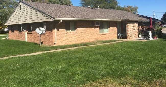
Property Detail
500 Laurel St
Des Moines-West Des Moines, IA
1ST ADD LOTS 1 & 2 BLK 7 /EX S42/
12-33-128-003
Dallas
Apartment
Iowa
B and X Area of moderate flood hazard, usually the area between the limits of the 100-year and 500-year floods.
1,2
2024
0.23 AC
2025
Dallas County
050901
Des Moines
2,856 SF
NEARBY LISTINGS FOR SALE OR LEASE
-
-
View all Waukee listings for sale on LoopNet.com
DEMOGRAPHICS near 500 Laurel St
1 mile
3 mile
5 mile
2025 Total Population
7,986
44,990
80,243
2030 Population
9,251
51,204
90,230
Pop Growth 2025-2030
+ 15.84%
+ 13.81%
+ 12.45%
Average Age
38
36
37
2025 Total Households
3,105
16,701
30,233
HH Growth 2025-2030
+ 15.94%
+ 14.09%
+ 12.71%
Median Household Inc
$108,301
$117,139
$117,837
Avg Household Size
2.60
2.70
2.60
2025 Avg HH Vehicles
2.00
2.00
2.00
Median Home Value
$296,694
$376,938
$395,074
Median Year Built
2005
2010
2010
Nearby Places
Map Layers
Map Styles
 Street
 Aerial
Layers
 Traffic
 Biking
Places
Listings with unknown addresses are not visible on the map
- Restaurants
- Banks
- Shops
- Fitness
- Groceries
PUBLIC TRANSPORTATION
AIRPORT
Des Moines International
Drive
Walk
Distance
Des Moines International
30 min
17.1 mi
SALE & LEASE HISTORY
LISTING DATE
SALE/LEASE

Oct 25, 2018
For Sale
Nearby Properties
Address
Land Use
TOTAL SIZE
Lot Size
Zoning
Address
Land Use
TOTAL SIZE
Lot Size
Zoning
218.93 AC
Address
Land Use
TOTAL SIZE
Lot Size
Zoning
48,937 SF
76.01 AC
Address
Land Use
TOTAL SIZE
Lot Size
Zoning
72,372 SF
74.45 AC
Address
Land Use
TOTAL SIZE
Lot Size
Zoning
37,325 SF
Address
Land Use
TOTAL SIZE
Lot Size
Zoning
2,864 SF
21.03 AC
Address
Land Use
TOTAL SIZE
Lot Size
Zoning
101,097 SF
30 AC
Address
Land Use
TOTAL SIZE
Lot Size
Zoning
123,722 SF
64.36 AC
Address
Land Use
TOTAL SIZE
Lot Size
Zoning
3,358 SF
21 AC
Address
Land Use
TOTAL SIZE
Lot Size
Zoning
11.91 AC
Address
Land Use
TOTAL SIZE
Lot Size
Zoning
Address
Land Use
TOTAL SIZE
Lot Size
Zoning
24,499 SF
5.75 AC
Address
Land Use
TOTAL SIZE
Lot Size
Zoning
39,505 SF
4.94 AC
Address
Land Use
TOTAL SIZE
Lot Size
Zoning
17.73 AC
Address
Land Use
TOTAL SIZE
Lot Size
Zoning
12.44 AC
Address
Land Use
TOTAL SIZE
Lot Size
Zoning
175,860 SF
40.72 AC
Address
Land Use
TOTAL SIZE
Lot Size
Zoning
17.76 AC
Address
Land Use
TOTAL SIZE
Lot Size
Zoning
87,362 SF
16.87 AC
Address
Land Use
TOTAL SIZE
Lot Size
Zoning
32,439 SF
7.89 AC
Address
Land Use
TOTAL SIZE
Lot Size
Zoning
Address
Land Use
TOTAL SIZE
Lot Size
Zoning
Address
Land Use
TOTAL SIZE
Lot Size
Zoning
3,930 SF
8.22 AC
Address
Land Use
TOTAL SIZE
Lot Size
Zoning
66.16 AC
Address
Land Use
TOTAL SIZE
Lot Size
Zoning
88,670 SF
15.44 AC
Address
Land Use
TOTAL SIZE
Lot Size
Zoning
14.16 AC
Address
Land Use
TOTAL SIZE
Lot Size
Zoning
30,943 SF
2.98 AC
Address
Land Use
TOTAL SIZE
Lot Size
Zoning
5.14 AC
Address
Land Use
TOTAL SIZE
Lot Size
Zoning
71,483 SF
8.26 AC
Address
Land Use
TOTAL SIZE
Lot Size
Zoning
14.31 AC
Address
Land Use
TOTAL SIZE
Lot Size
Zoning
66,997 SF
8.95 AC
Address
Land Use
TOTAL SIZE
Lot Size
Zoning
89,765 SF
9.73 AC
The World's #1 Commercial Real Estate Marketplace
Connect with us
© 2026 CoStar Group
The information above has been obtained from sources believed reliable. While we do not doubt its accuracy we have not verified it and make no guarantee, warranty or representation about it. It is your responsibility to independently confirm its accuracy and completeness. Any projections, opinions, assumptions, or estimates used are for example only and do not represent the current or future performance of the property. The value of this transaction to you depends on tax and other factors which should be evaluated by your tax, financial, and legal advisors. You and your advisors should conduct a careful, independent investigation of the property to determine to your satisfaction the suitability of the property for your needs.