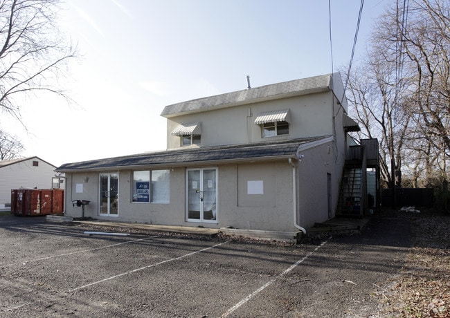
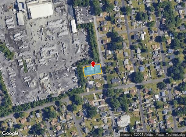
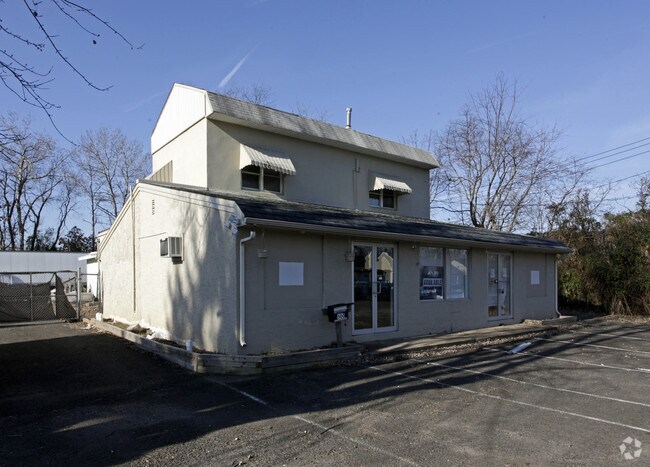
Property Record
500 Linton Ave, Croydon, PA 19021
NEARBY LISTINGS FOR SALE OR LEASE
Property Detail
500 Linton Ave
Philadelphia-Camden-Wilmington, PA-NJ-DE-MD
Land Assn
05-012-079
LOTS #299 THRU 301 LEAMINGTON LAND ASSN 90X172
Retailwithmorethanonenonretailuse
Bucks
X
Pennsylvania
34005C0109F
299-3
2024
0.36 AC
2025
Lower Bucks County
100302
Philadelphia
4,502 SF
DEMOGRAPHICS near 500 Linton Ave
1 mile
3 mile
5 mile
2024 Total Population
10,460
83,843
242,134
2029 Population
10,411
84,195
241,805
Pop Growth 2024-2029
(0.47%)
+ 0.42%
(0.14%)
Average Age
41
41
41
2024 Total Households
3,975
32,395
91,449
HH Growth 2024-2029
(0.55%)
+ 0.42%
(0.18%)
Median Household Inc
$64,022
$73,168
$79,737
Avg Household Size
2.60
2.50
2.60
2024 Avg HH Vehicles
2.00
2.00
2.00
Median Home Value
$242,372
$255,639
$257,315
Median Year Built
1957
1965
1965
Nearby Places
Map Layers
Map Styles
 Street
 Aerial
Transit
 Traffic
 Biking
Places
Listings with unknown addresses are not visible on the map
- Restaurants
- Banks
- Shops
- Fitness
- Groceries
PUBLIC TRANSPORTATION
COMMUTER RAIL
Croydon (R7 - Southeastern Pennsylvania Transportation Authority Regional Rail (SEPTA Regional Rail))
Drive
Walk
Distance
Croydon (R7 - Southeastern Pennsylvania Transportation Authority Regional Rail (SEPTA Regional Rail))
4 min
20 min
1.0 mi
Eddington (R7 - Southeastern Pennsylvania Transportation Authority Regional Rail (SEPTA Regional Rail))
Drive
Walk
Distance
Eddington (R7 - Southeastern Pennsylvania Transportation Authority Regional Rail (SEPTA Regional Rail))
6 min
2.8 mi
AIRPORT
Trenton Mercer
Drive
Walk
Distance
Trenton Mercer
30 min
17.8 mi
Philadelphia International
Drive
Walk
Distance
Philadelphia International
45 min
29.0 mi
Freight Ports
Port of Philadelphia
Drive
Walk
Distance
Port of Philadelphia
25 min
15.3 mi
Nearby Properties
Address
Land Use
TOTAL SIZE
Lot Size
Zoning
Address
Land Use
TOTAL SIZE
Lot Size
Zoning
22,688 SF
32.55 AC
BLI1
Address
Land Use
TOTAL SIZE
Lot Size
Zoning
Address
Land Use
TOTAL SIZE
Lot Size
Zoning
32.72 AC
Address
Land Use
TOTAL SIZE
Lot Size
Zoning
376 SF
32.32 AC
B-3
Address
Land Use
TOTAL SIZE
Lot Size
Zoning
16.23 AC
R-3
Address
Land Use
TOTAL SIZE
Lot Size
Zoning
253,500 SF
24.28 AC
BLI1
Address
Land Use
TOTAL SIZE
Lot Size
Zoning
1,325 SF
18.73 AC
Address
Land Use
TOTAL SIZE
Lot Size
Zoning
9.65 AC
Address
Land Use
TOTAL SIZE
Lot Size
Zoning
Address
Land Use
TOTAL SIZE
Lot Size
Zoning
2.96 AC
HC-1
Address
Land Use
TOTAL SIZE
Lot Size
Zoning
372,324 SF
17 AC
Address
Land Use
TOTAL SIZE
Lot Size
Zoning
11 AC
TRN
Address
Land Use
TOTAL SIZE
Lot Size
Zoning
15.09 AC
I-1
Address
Land Use
TOTAL SIZE
Lot Size
Zoning
10.73 AC
BLI1
Address
Land Use
TOTAL SIZE
Lot Size
Zoning
Address
Land Use
TOTAL SIZE
Lot Size
Zoning
16,918 SF
13.56 AC
B-3
Address
Land Use
TOTAL SIZE
Lot Size
Zoning
1,997 SF
2.17 AC
Address
Land Use
TOTAL SIZE
Lot Size
Zoning
3.74 AC
Address
Land Use
TOTAL SIZE
Lot Size
Zoning
8.60 AC
R-1
Address
Land Use
TOTAL SIZE
Lot Size
Zoning
2.46 AC
W-1
Address
Land Use
TOTAL SIZE
Lot Size
Zoning
242 AC
OS-1
Address
Land Use
TOTAL SIZE
Lot Size
Zoning
8.40 AC
Address
Land Use
TOTAL SIZE
Lot Size
Zoning
4.01 AC
Address
Land Use
TOTAL SIZE
Lot Size
Zoning
120 SF
10.50 AC
B-3
Address
Land Use
TOTAL SIZE
Lot Size
Zoning
4.41 AC
Address
Land Use
TOTAL SIZE
Lot Size
Zoning
9.15 AC
B2
Address
Land Use
TOTAL SIZE
Lot Size
Zoning
8.93 AC
B1
Address
Land Use
TOTAL SIZE
Lot Size
Zoning
19,518 SF
10.81 AC
I-1
Address
Land Use
TOTAL SIZE
Lot Size
Zoning
38,590 SF
1.82 AC
TRN
Address
Land Use
TOTAL SIZE
Lot Size
Zoning
43,445 SF
5.96 AC
The World's #1 Commercial Real Estate Marketplace
Connect with us
© 2026 CoStar Group
The information above has been obtained from sources believed reliable. While we do not doubt its accuracy we have not verified it and make no guarantee, warranty or representation about it. It is your responsibility to independently confirm its accuracy and completeness. Any projections, opinions, assumptions, or estimates used are for example only and do not represent the current or future performance of the property. The value of this transaction to you depends on tax and other factors which should be evaluated by your tax, financial, and legal advisors. You and your advisors should conduct a careful, independent investigation of the property to determine to your satisfaction the suitability of the property for your needs.