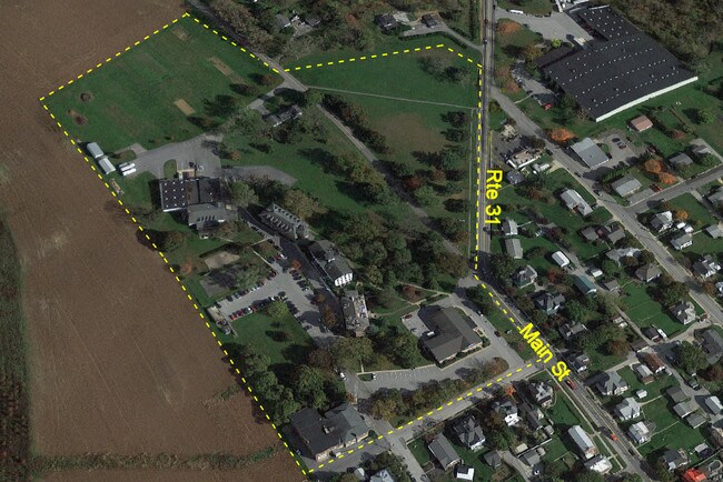
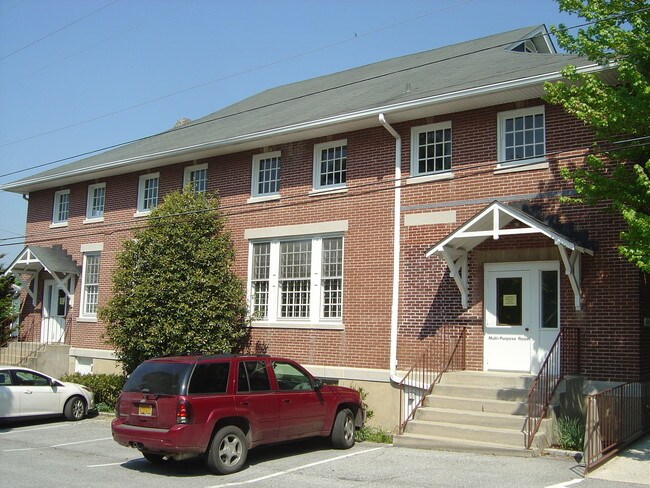
Property Record
500 Main St, New Windsor, MD 21776


Property Detail
500 Main St
11-016340
TRACT 2 - 6.7153 ACS 500 E MAIN ST NEW WINDSOR
Multifamilydwelling
Carroll
EMPLO
Maryland
B and X Area of moderate flood hazard, usually the area between the limits of the 100-year and 500-year floods.
6.72 AC
2025
Carroll County
2025
Baltimore
511000
Baltimore-Columbia-Towson, MD
2,000 SF
NEARBY LISTINGS FOR SALE OR LEASE
-
-
View all New Windsor listings for sale on LoopNet.com
DEMOGRAPHICS near 500 Main St
1 mile
3 mile
5 mile
2025 Total Population
2,165
4,212
19,125
2030 Population
2,270
4,354
19,550
Pop Growth 2025-2030
+ 4.85%
+ 3.37%
+ 2.22%
Average Age
42
42
42
2025 Total Households
850
1,621
7,278
HH Growth 2025-2030
+ 4.94%
+ 3.45%
+ 2.27%
Median Household Inc
$103,049
$111,567
$108,548
Avg Household Size
2.50
2.60
2.60
2025 Avg HH Vehicles
2.00
2.00
2.00
Median Home Value
$392,575
$415,895
$411,858
Median Year Built
1972
1973
1982
Nearby Places
Map Layers
Map Styles
 Street
 Aerial
Transit
 Traffic
 Biking
Places
Listings with unknown addresses are not visible on the map
- Restaurants
- Banks
- Shops
- Fitness
- Groceries
Nearby Properties
Address
Land Use
TOTAL SIZE
Lot Size
Zoning
Address
Land Use
TOTAL SIZE
Lot Size
Zoning
62,493 SF
30.01 AC
PUBLI
Address
Land Use
TOTAL SIZE
Lot Size
Zoning
26,856 SF
0.63 AC
PUBLI
Address
Land Use
TOTAL SIZE
Lot Size
Zoning
43,352 SF
3.25 AC
PUBLI
Address
Land Use
TOTAL SIZE
Lot Size
Zoning
18,000 SF
7.67 AC
EMPLO
Address
Land Use
TOTAL SIZE
Lot Size
Zoning
3,514 SF
73.62 AC
AGRIC
Address
Land Use
TOTAL SIZE
Lot Size
Zoning
121,412 SF
36.78 AC
INDUS
Address
Land Use
TOTAL SIZE
Lot Size
Zoning
16,000 SF
2.77 AC
PUBLI
Address
Land Use
TOTAL SIZE
Lot Size
Zoning
10,990 SF
207.33 AC
AGRIC
Address
Land Use
TOTAL SIZE
Lot Size
Zoning
75,389 SF
4.76 AC
EMPLO
Address
Land Use
TOTAL SIZE
Lot Size
Zoning
25,784 SF
9.21 AC
INDUS
Address
Land Use
TOTAL SIZE
Lot Size
Zoning
2,520 SF
26.40 AC
PUBLI
Address
Land Use
TOTAL SIZE
Lot Size
Zoning
5,738 SF
0.26 AC
VILLA
Address
Land Use
TOTAL SIZE
Lot Size
Zoning
133.57 AC
AGRIC
Address
Land Use
TOTAL SIZE
Lot Size
Zoning
60.15 AC
AGRIC
Address
Land Use
TOTAL SIZE
Lot Size
Zoning
7,854 SF
3.07 AC
AGRIC
Address
Land Use
TOTAL SIZE
Lot Size
Zoning
0.51 AC
PUBLI
Address
Land Use
TOTAL SIZE
Lot Size
Zoning
3,200 SF
4.52 AC
AGRIC
Address
Land Use
TOTAL SIZE
Lot Size
Zoning
19,200 SF
3.16 AC
I-1
Address
Land Use
TOTAL SIZE
Lot Size
Zoning
87.09 AC
AGRIC
Address
Land Use
TOTAL SIZE
Lot Size
Zoning
13,829 SF
3.17 AC
I-1
Address
Land Use
TOTAL SIZE
Lot Size
Zoning
1,456 SF
0.31 AC
NEIGH
Address
Land Use
TOTAL SIZE
Lot Size
Zoning
5,000 SF
2.59 AC
R-1
Address
Land Use
TOTAL SIZE
Lot Size
Zoning
2,024 SF
1 AC
AGRIC
Address
Land Use
TOTAL SIZE
Lot Size
Zoning
5,090 SF
0.24 AC
VILLA
Address
Land Use
TOTAL SIZE
Lot Size
Zoning
6,048 SF
4.14 AC
INDUS
Address
Land Use
TOTAL SIZE
Lot Size
Zoning
2,520 SF
0.75 AC
AGRIC
Address
Land Use
TOTAL SIZE
Lot Size
Zoning
60.55 AC
AGRIC
Address
Land Use
TOTAL SIZE
Lot Size
Zoning
1,768 SF
0.15 AC
VILLA
Address
Land Use
TOTAL SIZE
Lot Size
Zoning
1,040 SF
1.81 AC
I-1
The World's #1 Commercial Real Estate Marketplace
Connect with us
© 2026 CoStar Group
The information above has been obtained from sources believed reliable. While we do not doubt its accuracy we have not verified it and make no guarantee, warranty or representation about it. It is your responsibility to independently confirm its accuracy and completeness. Any projections, opinions, assumptions, or estimates used are for example only and do not represent the current or future performance of the property. The value of this transaction to you depends on tax and other factors which should be evaluated by your tax, financial, and legal advisors. You and your advisors should conduct a careful, independent investigation of the property to determine to your satisfaction the suitability of the property for your needs.