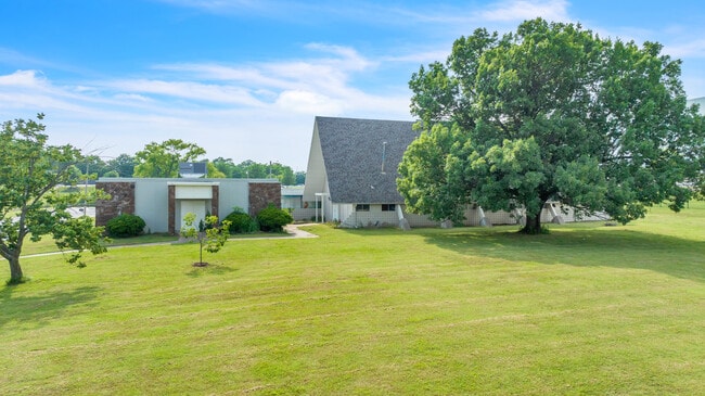
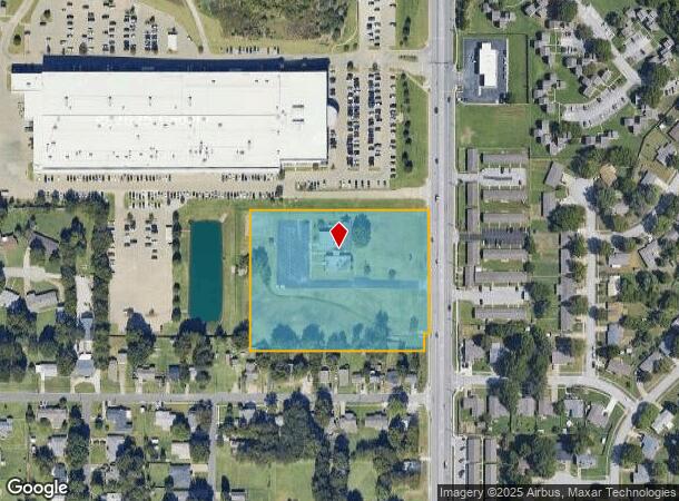
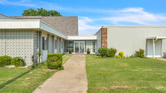
Property Record
500 N 9Th St, Broken Arrow, OK 74012
NEARBY LISTINGS FOR SALE OR LEASE
Property Detail
500 N 9Th St
Tulsa, OK
Mound View Addn
80555-84-11-13080
LT 1 LESS BEG 25W NEC LT 10 TH W15 N50 E15 S50 TO POB BLK 1
Religious
Tulsa
X
Oklahoma
40143C0392L
1,10
0
4.66 AC
2025
Southeast
007402
Tulsa
8,274 SF
DEMOGRAPHICS near 500 N 9Th St
1 Mile
3 Mile
5 Mile
2024 Total Population
5,795
59,839
143,025
2029 Population
6,085
63,012
151,778
Pop Growth 2024-2029
+ 5.00%
+ 5.30%
+ 6.12%
Average Age
40
38
38
2024 Total Households
2,411
23,235
54,050
HH Growth 2024-2029
+ 5.02%
+ 5.36%
+ 5.99%
Median Household Inc
$51,714
$70,418
$73,265
Avg Household Size
2.30
2.50
2.60
2024 Avg HH Vehicles
2.00
2.00
2.00
Median Home Value
$168,535
$191,636
$199,619
Median Year Built
1976
1992
1993
Nearby Places
Map Layers
Map Styles
 Street
 Aerial
- Restaurants
- Banks
- Shops
- Fitness
- Groceries
PUBLIC TRANSPORTATION
AIRPORT
Tulsa International
DRIVE
WALK
Distance
Tulsa International
26 min
17.3 mi
Freight Ports
Tulsa Port Of Catoosa
DRIVE
WALK
Distance
Tulsa Port Of Catoosa
25 min
14.2 mi
SALE & LEASE HISTORY
LISTING DATE
SALE/LEASE

Aug 22, 2023
For Sale
Nearby Properties
Address
Land Use
TOTAL SIZE
Lot Size
Zoning
Address
Land Use
TOTAL SIZE
Lot Size
Zoning
197,676 SF
13.38 AC
CH
Address
Land Use
TOTAL SIZE
Lot Size
Zoning
435,822 SF
43.42 AC
R1
Address
Land Use
TOTAL SIZE
Lot Size
Zoning
115,003 SF
59.09 AC
CG
Address
Land Use
TOTAL SIZE
Lot Size
Zoning
125,902 SF
19.15 AC
CH
Address
Land Use
TOTAL SIZE
Lot Size
Zoning
59,108 SF
11.18 AC
R3
Address
Land Use
TOTAL SIZE
Lot Size
Zoning
53,139 SF
108.91 AC
A1
Address
Land Use
TOTAL SIZE
Lot Size
Zoning
84,927 SF
4.81 AC
RM2
Address
Land Use
TOTAL SIZE
Lot Size
Zoning
75,444 SF
23.92 AC
R1
Address
Land Use
TOTAL SIZE
Lot Size
Zoning
58,695 SF
5.34 AC
RM
Address
Land Use
TOTAL SIZE
Lot Size
Zoning
77,260 SF
0.58 AC
R3
Address
Land Use
TOTAL SIZE
Lot Size
Zoning
49,113 SF
5.42 AC
R3
Address
Land Use
TOTAL SIZE
Lot Size
Zoning
222,768 SF
20.24 AC
CS
Address
Land Use
TOTAL SIZE
Lot Size
Zoning
68,478 SF
9.27 AC
R1
Address
Land Use
TOTAL SIZE
Lot Size
Zoning
67,149 SF
28.56 AC
R2
Address
Land Use
TOTAL SIZE
Lot Size
Zoning
58,627 SF
6.07 AC
CG
Address
Land Use
TOTAL SIZE
Lot Size
Zoning
363,154 SF
23.09 AC
IL
Address
Land Use
TOTAL SIZE
Lot Size
Zoning
71,362 SF
14.08 AC
RD
Address
Land Use
TOTAL SIZE
Lot Size
Zoning
39,733 SF
9.36 AC
A1
Address
Land Use
TOTAL SIZE
Lot Size
Zoning
60,790 SF
10.84 AC
R1
Address
Land Use
TOTAL SIZE
Lot Size
Zoning
11,601 SF
38.18 AC
RS1
Address
Land Use
TOTAL SIZE
Lot Size
Zoning
268,496 SF
19.31 AC
CN
Address
Land Use
TOTAL SIZE
Lot Size
Zoning
36,408 SF
10.46 AC
IL
Address
Land Use
TOTAL SIZE
Lot Size
Zoning
239,868 SF
14.84 AC
CG
Address
Land Use
TOTAL SIZE
Lot Size
Zoning
13,691 SF
2.04 AC
CH
Address
Land Use
TOTAL SIZE
Lot Size
Zoning
24,000 SF
7.50 AC
R1
Address
Land Use
TOTAL SIZE
Lot Size
Zoning
8.25 AC
CH
Address
Land Use
TOTAL SIZE
Lot Size
Zoning
71,143 SF
4.43 AC
R1
Address
Land Use
TOTAL SIZE
Lot Size
Zoning
367,352 SF
17.83 AC
CG
Address
Land Use
TOTAL SIZE
Lot Size
Zoning
59,222 SF
5.12 AC
IH
Address
Land Use
TOTAL SIZE
Lot Size
Zoning
28,071 SF
The World's #1 Commercial Real Estate Marketplace
Connect with us
© 2025 CoStar Group
The information above has been obtained from sources believed reliable. While we do not doubt its accuracy we have not verified it and make no guarantee, warranty or representation about it. It is your responsibility to independently confirm its accuracy and completeness. Any projections, opinions, assumptions, or estimates used are for example only and do not represent the current or future performance of the property. The value of this transaction to you depends on tax and other factors which should be evaluated by your tax, financial, and legal advisors. You and your advisors should conduct a careful, independent investigation of the property to determine to your satisfaction the suitability of the property for your needs.