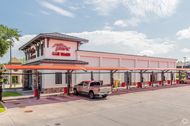
Property Record
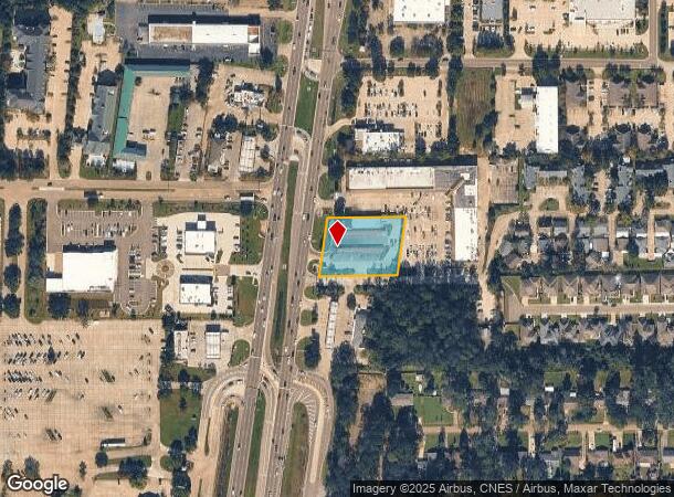
500 N Highway 190, Covington, LA 70433


Property Detail
500 N Highway 190
Slidell-Mandeville-Covington, LA
PT LOT A1 MEAS 180 X 240 SEC 15 7 11 CB 1236 849 CB 1401 133 INST NO 1126139 INST NO 1583342 INST NO 1594294 INST NO 2137283
26864
ST TAMMANY
Commercialnec
Louisiana
2025
a1
2025
0.98 AC
040609
Mandeville/Covington
3,420 SF
New Orleans/Metairie/Kenner
NEARBY LISTINGS FOR SALE OR LEASE
-
-
View all Covington listings for sale on LoopNet.com
DEMOGRAPHICS near 500 N Highway 190
1 mile
3 mile
5 mile
2025 Total Population
5,963
35,195
90,429
2030 Population
6,147
36,402
93,216
Pop Growth 2025-2030
+ 3.09%
+ 3.43%
+ 3.08%
Average Age
41
42
42
2025 Total Households
2,559
14,274
35,739
HH Growth 2025-2030
+ 2.81%
+ 3.45%
+ 3.14%
Median Household Inc
$79,109
$84,740
$82,768
Avg Household Size
2.30
2.40
2.50
2025 Avg HH Vehicles
2.00
2.00
2.00
Median Home Value
$321,524
$347,929
$348,925
Median Year Built
2001
1996
1995
Nearby Places
Map Layers
Map Styles
 Street
 Aerial
Layers
 Traffic
 Biking
Places
Listings with unknown addresses are not visible on the map
- Restaurants
- Banks
- Shops
- Fitness
- Groceries
PUBLIC TRANSPORTATION
AIRPORT
Louis Armstrong New Orleans International
Drive
Walk
Distance
Louis Armstrong New Orleans International
52 min
38.8 mi
Freight Ports
Port of New Orleans
Drive
Walk
Distance
Port of New Orleans
56 min
39.8 mi
Nearby Properties
Address
Land Use
TOTAL SIZE
Lot Size
Zoning
Address
Land Use
TOTAL SIZE
Lot Size
Zoning
Address
Land Use
TOTAL SIZE
Lot Size
Zoning
515,547 SF
20.54 AC
Address
Land Use
TOTAL SIZE
Lot Size
Zoning
Address
Land Use
TOTAL SIZE
Lot Size
Zoning
178,608 SF
34.02 AC
Address
Land Use
TOTAL SIZE
Lot Size
Zoning
200,000 SF
0.28 AC
Address
Land Use
TOTAL SIZE
Lot Size
Zoning
Address
Land Use
TOTAL SIZE
Lot Size
Zoning
0.92 AC
Address
Land Use
TOTAL SIZE
Lot Size
Zoning
11.91 AC
Address
Land Use
TOTAL SIZE
Lot Size
Zoning
Address
Land Use
TOTAL SIZE
Lot Size
Zoning
86,167 SF
0.71 AC
Address
Land Use
TOTAL SIZE
Lot Size
Zoning
201,095 SF
Address
Land Use
TOTAL SIZE
Lot Size
Zoning
68,478 SF
6.64 AC
Address
Land Use
TOTAL SIZE
Lot Size
Zoning
66,500 SF
4.35 AC
Address
Land Use
TOTAL SIZE
Lot Size
Zoning
102,470 SF
10.50 AC
Address
Land Use
TOTAL SIZE
Lot Size
Zoning
57,360 SF
2.77 AC
Address
Land Use
TOTAL SIZE
Lot Size
Zoning
205,612 SF
23.60 AC
Address
Land Use
TOTAL SIZE
Lot Size
Zoning
131,925 SF
2.02 AC
Address
Land Use
TOTAL SIZE
Lot Size
Zoning
38,976 SF
6.80 AC
Address
Land Use
TOTAL SIZE
Lot Size
Zoning
92,535 SF
2.80 AC
Address
Land Use
TOTAL SIZE
Lot Size
Zoning
Address
Land Use
TOTAL SIZE
Lot Size
Zoning
114,823 SF
4.57 AC
Address
Land Use
TOTAL SIZE
Lot Size
Zoning
124,002 SF
20.55 AC
Address
Land Use
TOTAL SIZE
Lot Size
Zoning
86,688 SF
3.75 AC
Address
Land Use
TOTAL SIZE
Lot Size
Zoning
114,727 SF
4.46 AC
Address
Land Use
TOTAL SIZE
Lot Size
Zoning
Address
Land Use
TOTAL SIZE
Lot Size
Zoning
48,866 SF
2.21 AC
Address
Land Use
TOTAL SIZE
Lot Size
Zoning
126 SF
2.55 AC
Address
Land Use
TOTAL SIZE
Lot Size
Zoning
70,689 SF
2.90 AC
Address
Land Use
TOTAL SIZE
Lot Size
Zoning
97,331 SF
25.37 AC
Address
Land Use
TOTAL SIZE
Lot Size
Zoning
48,200 SF
1.95 AC
The World's #1 Commercial Real Estate Marketplace
Connect with us
© 2026 CoStar Group
The information above has been obtained from sources believed reliable. While we do not doubt its accuracy we have not verified it and make no guarantee, warranty or representation about it. It is your responsibility to independently confirm its accuracy and completeness. Any projections, opinions, assumptions, or estimates used are for example only and do not represent the current or future performance of the property. The value of this transaction to you depends on tax and other factors which should be evaluated by your tax, financial, and legal advisors. You and your advisors should conduct a careful, independent investigation of the property to determine to your satisfaction the suitability of the property for your needs.