Property Record
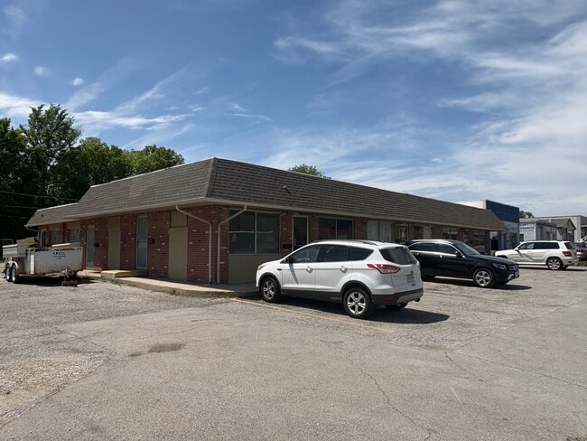
500 N Scott Ave, Belton, MO 64012


Property Detail
500 N Scott Ave
1394700
BG 30W SECR SWNE, N117 W177.36 SE117.74 ETC
Regionalshoppingcenterormallwithanchorstore
Cass
B and X Area of moderate flood hazard, usually the area between the limits of the 100-year and 500-year floods.
Missouri
2023
0.46 AC
2025
Cass County
060001
Kansas City
4,800 SF
Kansas City, MO-KS
NEARBY LISTINGS FOR SALE OR LEASE
DEMOGRAPHICS near 500 N Scott Ave
1 mile
3 mile
5 mile
2025 Total Population
8,585
35,183
73,402
2030 Population
8,967
36,677
76,171
Pop Growth 2025-2030
+ 4.45%
+ 4.25%
+ 3.77%
Average Age
39
39
40
2025 Total Households
3,413
13,985
28,322
HH Growth 2025-2030
+ 4.69%
+ 4.43%
+ 3.90%
Median Household Inc
$66,375
$64,277
$72,762
Avg Household Size
2.50
2.50
2.50
2025 Avg HH Vehicles
2.00
2.00
2.00
Median Home Value
$174,188
$197,250
$251,153
Median Year Built
1976
1990
1989
Nearby Places
Map Layers
Map Styles
 Street
 Aerial
Layers
 Traffic
 Biking
Places
Listings with unknown addresses are not visible on the map
- Restaurants
- Banks
- Shops
- Fitness
- Groceries
PUBLIC TRANSPORTATION
AIRPORT
Kansas City International
Drive
Walk
Distance
Kansas City International
55 min
40.6 mi
SALE & LEASE HISTORY
LISTING DATE
SALE/LEASE

Sep 25, 2016
For Lease
Nov 15, 2017
For Lease
May 15, 2024
For Sale
Mar 03, 2026
For Lease
Nearby Properties
Address
Land Use
TOTAL SIZE
Lot Size
Zoning
Address
Land Use
TOTAL SIZE
Lot Size
Zoning
38.18 AC
Address
Land Use
TOTAL SIZE
Lot Size
Zoning
11.65 AC
Address
Land Use
TOTAL SIZE
Lot Size
Zoning
4,490 SF
27.52 AC
Address
Land Use
TOTAL SIZE
Lot Size
Zoning
456,840 SF
29.46 AC
Address
Land Use
TOTAL SIZE
Lot Size
Zoning
915,528 SF
72.47 AC
Address
Land Use
TOTAL SIZE
Lot Size
Zoning
15.22 AC
Address
Land Use
TOTAL SIZE
Lot Size
Zoning
366,600 SF
9 AC
Address
Land Use
TOTAL SIZE
Lot Size
Zoning
646,513 SF
113.86 AC
Address
Land Use
TOTAL SIZE
Lot Size
Zoning
447,462 SF
37.91 AC
Address
Land Use
TOTAL SIZE
Lot Size
Zoning
631,055 SF
71.76 AC
Address
Land Use
TOTAL SIZE
Lot Size
Zoning
267,428 SF
Address
Land Use
TOTAL SIZE
Lot Size
Zoning
425,779 SF
23.23 AC
Address
Land Use
TOTAL SIZE
Lot Size
Zoning
372,085 SF
17.16 AC
Address
Land Use
TOTAL SIZE
Lot Size
Zoning
24,132 SF
36.55 AC
Address
Land Use
TOTAL SIZE
Lot Size
Zoning
446,900 SF
19.33 AC
Address
Land Use
TOTAL SIZE
Lot Size
Zoning
944,109 SF
17.75 AC
Address
Land Use
TOTAL SIZE
Lot Size
Zoning
90,842 SF
9 AC
Address
Land Use
TOTAL SIZE
Lot Size
Zoning
53,306 SF
6.70 AC
Address
Land Use
TOTAL SIZE
Lot Size
Zoning
313,997 SF
20.57 AC
Address
Land Use
TOTAL SIZE
Lot Size
Zoning
303,625 SF
Address
Land Use
TOTAL SIZE
Lot Size
Zoning
17,590 SF
18.30 AC
Address
Land Use
TOTAL SIZE
Lot Size
Zoning
80,976 SF
1.82 AC
Address
Land Use
TOTAL SIZE
Lot Size
Zoning
5.46 AC
Address
Land Use
TOTAL SIZE
Lot Size
Zoning
402,609 SF
15.11 AC
Address
Land Use
TOTAL SIZE
Lot Size
Zoning
611,460 SF
23.70 AC
Address
Land Use
TOTAL SIZE
Lot Size
Zoning
76,487 SF
9.69 AC
Address
Land Use
TOTAL SIZE
Lot Size
Zoning
137,544 SF
11.36 AC
Address
Land Use
TOTAL SIZE
Lot Size
Zoning
Address
Land Use
TOTAL SIZE
Lot Size
Zoning
567,823 SF
9.81 AC
Address
Land Use
TOTAL SIZE
Lot Size
Zoning
47,994 SF
12.60 AC
The World's #1 Commercial Real Estate Marketplace
Connect with us
© 2026 CoStar Group
The information above has been obtained from sources believed reliable. While we do not doubt its accuracy we have not verified it and make no guarantee, warranty or representation about it. It is your responsibility to independently confirm its accuracy and completeness. Any projections, opinions, assumptions, or estimates used are for example only and do not represent the current or future performance of the property. The value of this transaction to you depends on tax and other factors which should be evaluated by your tax, financial, and legal advisors. You and your advisors should conduct a careful, independent investigation of the property to determine to your satisfaction the suitability of the property for your needs.