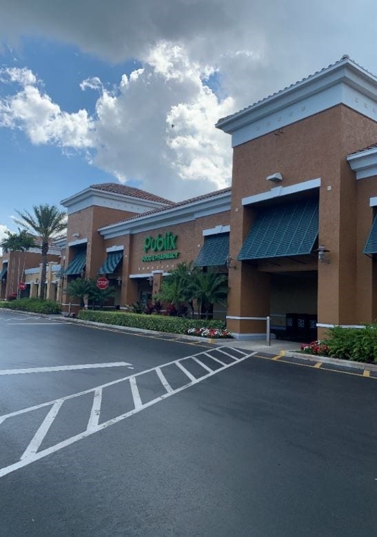
Property Record
500 N Us Highway 1, Tequesta, FL 33469

Current Lease Availabilities
NEARBY LISTINGS FOR SALE OR LEASE
Property Detail
500 N Us Highway 1
West Palm Beach-Boca Raton-Delray Beach, FL
Acreage & Unrec
60-43-40-30-00-001-0190
30-40-43~ SLY 291.75 FT OF ELY 209.21 FT (LESS NLY 186.99 FT OF SLY 256.99 FT OF WLY 154.33 FT OF ELY 174.33 FT) & S 11 FT OF W 430 FT OF ELY 639.21 FT OF GOV LT 1 LYG W OF &
Regionalshoppingcenterormallwithanchorstore
Palm Beach
X
Florida
12099C0179F
1
2024
8.13 AC
2025
Jupiter
000102
South Florida
62,036 SF
DEMOGRAPHICS near 500 N Us Highway 1
1 Mile
3 Mile
5 Mile
2024 Total Population
7,946
36,025
76,401
2029 Population
8,374
38,199
80,288
Pop Growth 2024-2029
+ 5.39%
+ 6.03%
+ 5.09%
Average Age
48
50
48
2024 Total Households
3,584
15,917
33,202
HH Growth 2024-2029
+ 5.16%
+ 6.50%
+ 5.30%
Median Household Inc
$86,507
$92,187
$95,771
Avg Household Size
2.10
2.20
2.20
2024 Avg HH Vehicles
2.00
2.00
2.00
Median Home Value
$456,766
$492,686
$510,624
Median Year Built
1981
1982
1986
Nearby Places
Map Layers
Map Styles
 Street
 Aerial
- Restaurants
- Banks
- Shops
- Fitness
- Groceries
PUBLIC TRANSPORTATION
AIRPORT
Palm Beach International
DRIVE
WALK
Distance
Palm Beach International
37 min
23.2 mi
Freight Ports
Port of Palm Beach
DRIVE
WALK
Distance
Port of Palm Beach
28 min
14.4 mi
Nearby Properties
Address
Land Use
TOTAL SIZE
Lot Size
Zoning
Address
Land Use
TOTAL SIZE
Lot Size
Zoning
46,972 SF
3.15 AC
R-3
Address
Land Use
TOTAL SIZE
Lot Size
Zoning
367,095 SF
50.80 AC
PI
Address
Land Use
TOTAL SIZE
Lot Size
Zoning
136,141 SF
7.47 AC
R3
Address
Land Use
TOTAL SIZE
Lot Size
Zoning
3,022 SF
34.81 AC
RS
Address
Land Use
TOTAL SIZE
Lot Size
Zoning
34,908 SF
49.67 AC
PI
Address
Land Use
TOTAL SIZE
Lot Size
Zoning
45,000 SF
2.29 AC
R-3
Address
Land Use
TOTAL SIZE
Lot Size
Zoning
143,460 SF
18.72 AC
PI
Address
Land Use
TOTAL SIZE
Lot Size
Zoning
241,373 SF
11.61 AC
I1
Address
Land Use
TOTAL SIZE
Lot Size
Zoning
152,592 SF
9.81 AC
WGC
Address
Land Use
TOTAL SIZE
Lot Size
Zoning
208,493 SF
24.68 AC
C2
Address
Land Use
TOTAL SIZE
Lot Size
Zoning
6,015 SF
74.59 AC
PI
Address
Land Use
TOTAL SIZE
Lot Size
Zoning
140,490 SF
11.37 AC
C2
Address
Land Use
TOTAL SIZE
Lot Size
Zoning
6,903 SF
21.46 AC
PO
Address
Land Use
TOTAL SIZE
Lot Size
Zoning
119,351 SF
11.70 AC
C2
Address
Land Use
TOTAL SIZE
Lot Size
Zoning
7,080 SF
4.44 AC
A80
Address
Land Use
TOTAL SIZE
Lot Size
Zoning
56,548 SF
5.54 AC
C2
Address
Land Use
TOTAL SIZE
Lot Size
Zoning
4,153 SF
9.74 AC
R3
Address
Land Use
TOTAL SIZE
Lot Size
Zoning
110,628 SF
12.10 AC
C-2
Address
Land Use
TOTAL SIZE
Lot Size
Zoning
114,225 SF
2.39 AC
M-U
Address
Land Use
TOTAL SIZE
Lot Size
Zoning
4.10 AC
B40
Address
Land Use
TOTAL SIZE
Lot Size
Zoning
51,630 SF
1.05 AC
US-1/ICW
Address
Land Use
TOTAL SIZE
Lot Size
Zoning
75,226 SF
5.56 AC
C-2
Address
Land Use
TOTAL SIZE
Lot Size
Zoning
43,485 SF
4.16 AC
C2
Address
Land Use
TOTAL SIZE
Lot Size
Zoning
6,282 SF
13.41 AC
PI
Address
Land Use
TOTAL SIZE
Lot Size
Zoning
18,302 SF
6.25 AC
RS
Address
Land Use
TOTAL SIZE
Lot Size
Zoning
19,191 SF
3.62 AC
C2
Address
Land Use
TOTAL SIZE
Lot Size
Zoning
99,164 SF
10.96 AC
C-2
Address
Land Use
TOTAL SIZE
Lot Size
Zoning
103,915 SF
9.92 AC
I2
Address
Land Use
TOTAL SIZE
Lot Size
Zoning
116,750 SF
13.01 AC
PI
Address
Land Use
TOTAL SIZE
Lot Size
Zoning
12,171 SF
3.98 AC
C2
The World's #1 Commercial Real Estate Marketplace
Connect with us
© 2026 CoStar Group
The information above has been obtained from sources believed reliable. While we do not doubt its accuracy we have not verified it and make no guarantee, warranty or representation about it. It is your responsibility to independently confirm its accuracy and completeness. Any projections, opinions, assumptions, or estimates used are for example only and do not represent the current or future performance of the property. The value of this transaction to you depends on tax and other factors which should be evaluated by your tax, financial, and legal advisors. You and your advisors should conduct a careful, independent investigation of the property to determine to your satisfaction the suitability of the property for your needs.