Property Record
500 Norris Rd, Bakersfield, CA 93308


Save to a Folder
{{folder.Name}}
{{folder.ListingIds.length}} Properties
{{folder.ListingIds.length}} Property
Create a New Folder
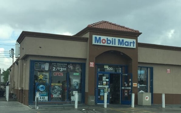
Property Detail
500 Norris Rd
Bakersfield-Delano, CA
TRACT 1086 , BLOCK A , LOT 6-8
112-162-08-00-1
KERN
Servicestation
California
C2
6-8
B and X Area of moderate flood hazard, usually the area between the limits of the 100-year and 500-year floods.
0.48 AC
2024
North Bakersfield
2025
Bakersfield
000103
NEARBY LISTINGS FOR SALE OR LEASE
DEMOGRAPHICS near 500 Norris Rd
1 mile
3 mile
5 mile
2025 Total Population
22,527
69,518
187,365
2030 Population
22,924
70,662
189,548
Pop Growth 2025-2030
+ 1.76%
+ 1.65%
+ 1.17%
Average Age
36
36
36
2025 Total Households
8,153
25,062
63,274
HH Growth 2025-2030
+ 1.68%
+ 1.63%
+ 1.22%
Median Household Inc
$46,674
$53,553
$56,643
Avg Household Size
2.70
2.70
2.90
2025 Avg HH Vehicles
1.00
2.00
2.00
Median Home Value
$213,854
$304,669
$325,295
Median Year Built
1963
1973
1972
Nearby Places
Map Layers
Map Styles
 Street
 Aerial
Layers
 Traffic
 Biking
Places
Listings with unknown addresses are not visible on the map
- Restaurants
- Banks
- Shops
- Fitness
- Groceries
PUBLIC TRANSPORTATION
COMMUTER RAIL
Drive
Walk
Distance
10 min
4.4 mi
AIRPORT
Meadows Field
Drive
Walk
Distance
Meadows Field
12 min
3.9 mi
Nearby Properties
Address
Land Use
TOTAL SIZE
Lot Size
Zoning
Address
Land Use
TOTAL SIZE
Lot Size
Zoning
2,645,250 SF
64.24 AC
M-2 PD H
Address
Land Use
TOTAL SIZE
Lot Size
Zoning
402,037 SF
17.72 AC
R1
Address
Land Use
TOTAL SIZE
Lot Size
Zoning
104,693 SF
2.09 AC
HOSP
Address
Land Use
TOTAL SIZE
Lot Size
Zoning
85,971 SF
5.31 AC
C-2
Address
Land Use
TOTAL SIZE
Lot Size
Zoning
16.04 AC
NR
Address
Land Use
TOTAL SIZE
Lot Size
Zoning
59,242 SF
3.01 AC
C2
Address
Land Use
TOTAL SIZE
Lot Size
Zoning
112,849 SF
5.31 AC
C-2
Address
Land Use
TOTAL SIZE
Lot Size
Zoning
30,326 SF
19 AC
M3
Address
Land Use
TOTAL SIZE
Lot Size
Zoning
2,032 SF
11.08 AC
M3
Address
Land Use
TOTAL SIZE
Lot Size
Zoning
10,064 SF
13.44 AC
R3
Address
Land Use
TOTAL SIZE
Lot Size
Zoning
155,550 SF
18.51 AC
M2
Address
Land Use
TOTAL SIZE
Lot Size
Zoning
63,428 SF
5.18 AC
C-2
Address
Land Use
TOTAL SIZE
Lot Size
Zoning
41,394 SF
14.74 AC
Address
Land Use
TOTAL SIZE
Lot Size
Zoning
87,389 SF
1.76 AC
M1
Address
Land Use
TOTAL SIZE
Lot Size
Zoning
Address
Land Use
TOTAL SIZE
Lot Size
Zoning
2,129 SF
11.42 AC
M-2
Address
Land Use
TOTAL SIZE
Lot Size
Zoning
151,797 SF
4.42 AC
R3
Address
Land Use
TOTAL SIZE
Lot Size
Zoning
3,383 SF
19.40 AC
M-2
Address
Land Use
TOTAL SIZE
Lot Size
Zoning
8 AC
M-3
Address
Land Use
TOTAL SIZE
Lot Size
Zoning
72,726 SF
13.15 AC
M2
Address
Land Use
TOTAL SIZE
Lot Size
Zoning
200,503 SF
5.85 AC
C-2-D
Address
Land Use
TOTAL SIZE
Lot Size
Zoning
54,960 SF
15.83 AC
M-2
Address
Land Use
TOTAL SIZE
Lot Size
Zoning
37,784 SF
0.76 AC
PCD
Address
Land Use
TOTAL SIZE
Lot Size
Zoning
141,662 SF
9.39 AC
R-2
Address
Land Use
TOTAL SIZE
Lot Size
Zoning
43,124 SF
0.44 AC
C2
Address
Land Use
TOTAL SIZE
Lot Size
Zoning
154,142 SF
8.04 AC
C2
Address
Land Use
TOTAL SIZE
Lot Size
Zoning
55,215 SF
3.93 AC
C-2
Address
Land Use
TOTAL SIZE
Lot Size
Zoning
1.50 AC
Address
Land Use
TOTAL SIZE
Lot Size
Zoning
8.58 AC
M-3
Address
Land Use
TOTAL SIZE
Lot Size
Zoning
39,024 SF
2.35 AC
C-O-D
The World's #1 Commercial Real Estate Marketplace
Connect with us
© 2026 CoStar Group
The information above has been obtained from sources believed reliable. While we do not doubt its accuracy we have not verified it and make no guarantee, warranty or representation about it. It is your responsibility to independently confirm its accuracy and completeness. Any projections, opinions, assumptions, or estimates used are for example only and do not represent the current or future performance of the property. The value of this transaction to you depends on tax and other factors which should be evaluated by your tax, financial, and legal advisors. You and your advisors should conduct a careful, independent investigation of the property to determine to your satisfaction the suitability of the property for your needs.