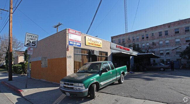
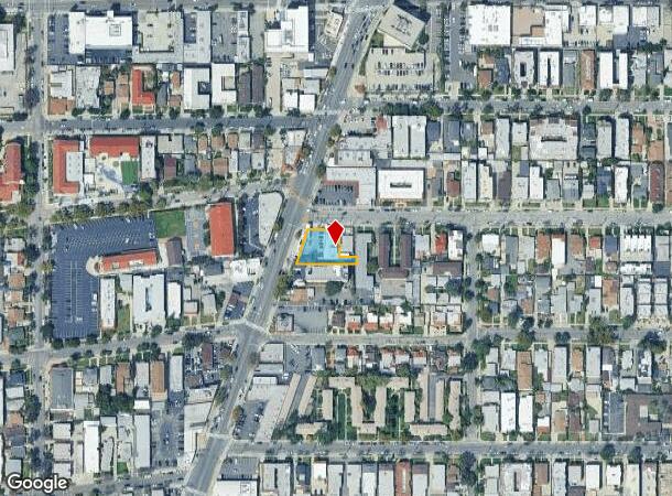
Property Record
500 S Glendale Ave, Glendale, CA 91205

NEARBY LISTINGS FOR SALE OR LEASE
-
-
-
-
-
-
-
No Photo
-
-
-
-
-
-
-
-
-
-
-
View all Glendale listings for sale on LoopNet.com
Property Detail
500 S Glendale Ave
Los Angeles-Long Beach-Glendale, CA
Childs Tract
5675-005-001
CHILDS TRACT LOT COM AT INTERSECTION OF S LINE OF LOMITA AVE 60 FT WIDE WITH SE LINE OF GLENDALE AVE 86 FT WIDE TH E ON SD S LINE 97.5 FT TH S 0 2050 W 80.26 FT TH S 89 3330 E 46.50 FT TH S E 106.72 FT TO BEG PART OF LOT 11
Regionalshoppingcenterormallwithanchorstore
Los Angeles
X
California
06037C1375F
11
2024
0.28 AC
2025
Glendale
302202
Los Angeles
4,572 SF
DEMOGRAPHICS near 500 S Glendale Ave
1 Mile
3 Mile
5 Mile
2024 Total Population
64,477
224,578
555,469
2029 Population
62,195
216,906
537,157
Pop Growth 2024-2029
(3.54%)
(3.42%)
(3.30%)
Average Age
42
42
41
2024 Total Households
25,750
87,964
223,070
HH Growth 2024-2029
(3.78%)
(3.67%)
(3.51%)
Median Household Inc
$56,217
$81,504
$77,636
Avg Household Size
2.40
2.50
2.40
2024 Avg HH Vehicles
1.00
2.00
2.00
Median Home Value
$727,719
$936,168
$982,729
Median Year Built
1968
1961
1958
Nearby Places
Map Layers
Map Styles
 Street
 Aerial
- Restaurants
- Banks
- Shops
- Fitness
- Groceries
PUBLIC TRANSPORTATION
COMMUTER RAIL
Glendale (Antelope Valley Line - Southern California Regional Rail Authority (Metrolink), Ventura County Line - Southern California Regional Rail Authority (Metrolink))
DRIVE
WALK
Distance
Glendale (Antelope Valley Line - Southern California Regional Rail Authority (Metrolink), Ventura County Line - Southern California Regional Rail Authority (Metrolink))
4 min
1.5 mi
Downtown Burbank (Antelope Valley Line - Southern California Regional Rail Authority (Metrolink), Ventura County Line - Southern California Regional Rail Authority (Metrolink))
DRIVE
WALK
Distance
Downtown Burbank (Antelope Valley Line - Southern California Regional Rail Authority (Metrolink), Ventura County Line - Southern California Regional Rail Authority (Metrolink))
11 min
5.3 mi
AIRPORT
Bob Hope
DRIVE
WALK
Distance
Bob Hope
18 min
10.7 mi
Los Angeles International
DRIVE
WALK
Distance
Los Angeles International
38 min
25.4 mi
Long Beach (Daugherty Field)
DRIVE
WALK
Distance
Long Beach (Daugherty Field)
42 min
29.0 mi
Freight Ports
Port of Long Beach
DRIVE
WALK
Distance
Port of Long Beach
45 min
30.9 mi
Nearby Properties
Address
Land Use
TOTAL SIZE
Lot Size
Zoning
Address
Land Use
TOTAL SIZE
Lot Size
Zoning
272,288 SF
24.26 AC
GLC3-C2-R4
Address
Land Use
TOTAL SIZE
Lot Size
Zoning
590,292 SF
8.21 AC
GLC3*
Address
Land Use
TOTAL SIZE
Lot Size
Zoning
359,197 SF
13.49 AC
GLENDALE M
Address
Land Use
TOTAL SIZE
Lot Size
Zoning
477,885 SF
2.52 AC
GLC3*
Address
Land Use
TOTAL SIZE
Lot Size
Zoning
979,623 SF
13.36 AC
GLM2
Address
Land Use
TOTAL SIZE
Lot Size
Zoning
920,082 SF
2.51 AC
GLC2-R4*
Address
Land Use
TOTAL SIZE
Lot Size
Zoning
309,008 SF
11.91 AC
LAM3
Address
Land Use
TOTAL SIZE
Lot Size
Zoning
251,317 SF
114.56 AC
LAR1
Address
Land Use
TOTAL SIZE
Lot Size
Zoning
985,517 SF
4.08 AC
GLC3
Address
Land Use
TOTAL SIZE
Lot Size
Zoning
349,519 SF
2.16 AC
GLM1*
Address
Land Use
TOTAL SIZE
Lot Size
Zoning
317,292 SF
36.67 AC
LAM3
Address
Land Use
TOTAL SIZE
Lot Size
Zoning
245,031 SF
2.21 AC
GLM2
Address
Land Use
TOTAL SIZE
Lot Size
Zoning
235,936 SF
1.58 AC
GLC2*
Address
Land Use
TOTAL SIZE
Lot Size
Zoning
457,694 SF
1.42 AC
GLC3*
Address
Land Use
TOTAL SIZE
Lot Size
Zoning
265,301 SF
0.17 AC
GLC3*
Address
Land Use
TOTAL SIZE
Lot Size
Zoning
122,988 SF
3.32 AC
GLC3*
Address
Land Use
TOTAL SIZE
Lot Size
Zoning
766,497 SF
2.10 AC
GLC2*
Address
Land Use
TOTAL SIZE
Lot Size
Zoning
220,624 SF
1.50 AC
GLC3-C2*
Address
Land Use
TOTAL SIZE
Lot Size
Zoning
638,414 SF
2.53 AC
GLC3-C2*
Address
Land Use
TOTAL SIZE
Lot Size
Zoning
214,087 SF
1.65 AC
GLC3*
Address
Land Use
TOTAL SIZE
Lot Size
Zoning
223,599 SF
1.43 AC
GLC3*
Address
Land Use
TOTAL SIZE
Lot Size
Zoning
189,663 SF
1.36 AC
GLC2*
Address
Land Use
TOTAL SIZE
Lot Size
Zoning
779,800 SF
5.39 AC
GLC2-C3*
Address
Land Use
TOTAL SIZE
Lot Size
Zoning
126,452 SF
9.27 AC
GLM2*
Address
Land Use
TOTAL SIZE
Lot Size
Zoning
212,943 SF
1.41 AC
GLC3-R4*
Address
Land Use
TOTAL SIZE
Lot Size
Zoning
280,778 SF
2.30 AC
GLC3*
Address
Land Use
TOTAL SIZE
Lot Size
Zoning
302,119 SF
1.41 AC
GLC2
Address
Land Use
TOTAL SIZE
Lot Size
Zoning
53,760 SF
4.60 AC
LAM1
Address
Land Use
TOTAL SIZE
Lot Size
Zoning
260,091 SF
1.02 AC
GLC2*
Address
Land Use
TOTAL SIZE
Lot Size
Zoning
284,476 SF
1.76 AC
The World's #1 Commercial Real Estate Marketplace
Connect with us
© 2025 CoStar Group
The information above has been obtained from sources believed reliable. While we do not doubt its accuracy we have not verified it and make no guarantee, warranty or representation about it. It is your responsibility to independently confirm its accuracy and completeness. Any projections, opinions, assumptions, or estimates used are for example only and do not represent the current or future performance of the property. The value of this transaction to you depends on tax and other factors which should be evaluated by your tax, financial, and legal advisors. You and your advisors should conduct a careful, independent investigation of the property to determine to your satisfaction the suitability of the property for your needs.