Property Record
500 S Highway 80, Benson, AZ 85602


NEARBY LISTINGS FOR SALE OR LEASE
-
-
View all Benson listings for sale on LoopNet.com
Property Detail
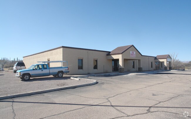
500 S Highway 80
123-23-412
Left An Arc Dist
Storemultistory
IN SWSE BY M&B BEG 53.39N OF SW COR OF SE4 TO POB THN N0DEG 04MI N W527.16 (R-527.14) THN SELY ALNG SWLY R/W LNE OF HWY 80 A DIS T OF 636.78 (R-633.06) THN N84DEG 50MIN W306.24 (R-308.07) TO POB EXC .442AC TO CITY OF BENSON PER #2023-09807 SEC 10-17-
X
Cochise
04003C1233F
Arizona
2024
1.59 AC
2025
Arizona SE & Sierra Vista Area
000301
Other Market Areas
11,404 SF
Sierra Vista-Douglas, AZ
DEMOGRAPHICS near 500 S Highway 80
1 Mile
3 Mile
5 Mile
2024 Total Population
3,084
6,066
8,300
2029 Population
3,224
6,281
8,567
Pop Growth 2024-2029
+ 4.54%
+ 3.54%
+ 3.22%
Average Age
48
49
49
2024 Total Households
1,486
2,852
3,821
HH Growth 2024-2029
+ 4.37%
+ 3.51%
+ 3.22%
Median Household Inc
$42,421
$49,999
$53,533
Avg Household Size
2.00
2.10
2.10
2024 Avg HH Vehicles
2.00
2.00
2.00
Median Home Value
$97,395
$134,252
$156,495
Median Year Built
1983
1986
1989
Nearby Places
Map Layers
Map Styles
 Street
 Aerial
- Restaurants
- Banks
- Shops
- Fitness
- Groceries
PUBLIC TRANSPORTATION
COMMUTER RAIL
DRIVE
WALK
Distance
2 min
13 min
0.7 mi
SALE & LEASE HISTORY
LISTING DATE
SALE/LEASE

Sep 23, 2016
For Sale
Jan 24, 2022
For Sale
Nearby Properties
Address
Land Use
TOTAL SIZE
Lot Size
Zoning
Address
Land Use
TOTAL SIZE
Lot Size
Zoning
98,040 SF
10.11 AC
Address
Land Use
TOTAL SIZE
Lot Size
Zoning
92,124 SF
8.87 AC
Address
Land Use
TOTAL SIZE
Lot Size
Zoning
13,260 SF
7.08 AC
Address
Land Use
TOTAL SIZE
Lot Size
Zoning
20,000 SF
8 AC
Address
Land Use
TOTAL SIZE
Lot Size
Zoning
7,395 SF
13.76 AC
Address
Land Use
TOTAL SIZE
Lot Size
Zoning
51,349 SF
6.58 AC
Address
Land Use
TOTAL SIZE
Lot Size
Zoning
19,143 SF
128.10 AC
Address
Land Use
TOTAL SIZE
Lot Size
Zoning
36,165 SF
2.20 AC
Address
Land Use
TOTAL SIZE
Lot Size
Zoning
42,726 SF
5.07 AC
Address
Land Use
TOTAL SIZE
Lot Size
Zoning
24,894 SF
20.05 AC
Address
Land Use
TOTAL SIZE
Lot Size
Zoning
22,060 SF
15.60 AC
Address
Land Use
TOTAL SIZE
Lot Size
Zoning
33,645 SF
3.21 AC
Address
Land Use
TOTAL SIZE
Lot Size
Zoning
41,677 SF
3.51 AC
Address
Land Use
TOTAL SIZE
Lot Size
Zoning
24,990 SF
3 AC
TR36
Address
Land Use
TOTAL SIZE
Lot Size
Zoning
28,583 SF
2.51 AC
Address
Land Use
TOTAL SIZE
Lot Size
Zoning
0.96 AC
Address
Land Use
TOTAL SIZE
Lot Size
Zoning
12,000 SF
1.38 AC
Address
Land Use
TOTAL SIZE
Lot Size
Zoning
3,802 SF
0.60 AC
Address
Land Use
TOTAL SIZE
Lot Size
Zoning
3,551 SF
0.10 AC
Address
Land Use
TOTAL SIZE
Lot Size
Zoning
2,601 SF
27.50 AC
Address
Land Use
TOTAL SIZE
Lot Size
Zoning
13,034 SF
1.48 AC
Address
Land Use
TOTAL SIZE
Lot Size
Zoning
8,907 SF
0.71 AC
Address
Land Use
TOTAL SIZE
Lot Size
Zoning
10,120 SF
Address
Land Use
TOTAL SIZE
Lot Size
Zoning
20,271 SF
2.20 AC
Address
Land Use
TOTAL SIZE
Lot Size
Zoning
45,160 SF
2.59 AC
Address
Land Use
TOTAL SIZE
Lot Size
Zoning
14,109 SF
10 AC
Address
Land Use
TOTAL SIZE
Lot Size
Zoning
8,568 SF
2.01 AC
Address
Land Use
TOTAL SIZE
Lot Size
Zoning
6,969 SF
5 AC
Address
Land Use
TOTAL SIZE
Lot Size
Zoning
15,383 SF
1.42 AC
Address
Land Use
TOTAL SIZE
Lot Size
Zoning
3,543 SF
0.87 AC
The World's #1 Commercial Real Estate Marketplace
Connect with us
© 2025 CoStar Group
The information above has been obtained from sources believed reliable. While we do not doubt its accuracy we have not verified it and make no guarantee, warranty or representation about it. It is your responsibility to independently confirm its accuracy and completeness. Any projections, opinions, assumptions, or estimates used are for example only and do not represent the current or future performance of the property. The value of this transaction to you depends on tax and other factors which should be evaluated by your tax, financial, and legal advisors. You and your advisors should conduct a careful, independent investigation of the property to determine to your satisfaction the suitability of the property for your needs.