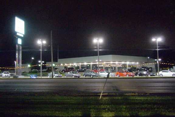
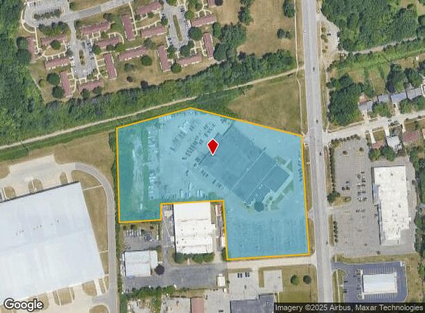
Property Record
500 S Opdyke Rd, Pontiac, MI 48341
NEARBY LISTINGS FOR SALE OR LEASE
Property Detail
500 S Opdyke Rd
Detroit-Warren-Dearborn, MI
Assessors Plat No 1
14-34-426-008
T3N, R10E, SEC 34 ASSESSOR'S PLAT NO 141 PART OF LOT 9 BEG AT PT DIST S 02-18-40 E 233.19 FT FROM NE LOT COR, TH S 02-18-40 E 89.70 FT, TH ALG CURVE TO LEFT, RAD 2924.79 FT, CHORD BEARS S 03-00-05 E 70.46 FT, DIST OF 70.46 FT, TH S 03-41-30 E 331.31
Vehiclerentalsvehiclesales
Oakland
X
Michigan
26125C0369F
9
2024
8 AC
2024
Pontiac
142300
Detroit
64,911 SF
DEMOGRAPHICS near 500 S Opdyke Rd
1 Mile
3 Mile
5 Mile
2024 Total Population
6,676
60,740
166,345
2029 Population
6,660
60,752
165,715
Pop Growth 2024-2029
(0.24%)
+ 0.02%
(0.38%)
Average Age
39
40
41
2024 Total Households
2,843
24,201
65,608
HH Growth 2024-2029
(0.21%)
(0.02%)
(0.40%)
Median Household Inc
$52,522
$56,126
$73,513
Avg Household Size
2.30
2.40
2.40
2024 Avg HH Vehicles
2.00
2.00
2.00
Median Home Value
$182,114
$218,151
$320,121
Median Year Built
1974
1967
1971
Nearby Places
Map Layers
Map Styles
 Street
 Aerial
- Restaurants
- Banks
- Shops
- Fitness
- Groceries
PUBLIC TRANSPORTATION
COMMUTER RAIL
Pontiac Amtrak Station (Wolverine - Amtrak)
DRIVE
WALK
Distance
Pontiac Amtrak Station (Wolverine - Amtrak)
7 min
3.2 mi
Troy Amtrak Station (Wolverine - Amtrak)
DRIVE
WALK
Distance
Troy Amtrak Station (Wolverine - Amtrak)
17 min
7.8 mi
AIRPORT
Windsor International
DRIVE
WALK
Distance
Windsor International
56 min
37.4 mi
Detroit Metro Wayne County
DRIVE
WALK
Distance
Detroit Metro Wayne County
59 min
44.5 mi
Freight Ports
Port of Toledo
DRIVE
WALK
Distance
Port of Toledo
107 min
88.0 mi
Nearby Properties
Address
Land Use
TOTAL SIZE
Lot Size
Zoning
Address
Land Use
TOTAL SIZE
Lot Size
Zoning
7,879,586 SF
457.68 AC
TR
Address
Land Use
TOTAL SIZE
Lot Size
Zoning
2,734,739 SF
80.39 AC
Address
Land Use
TOTAL SIZE
Lot Size
Zoning
803,597 SF
67 AC
SP
Address
Land Use
TOTAL SIZE
Lot Size
Zoning
238,755 SF
Address
Land Use
TOTAL SIZE
Lot Size
Zoning
453,700 SF
Address
Land Use
TOTAL SIZE
Lot Size
Zoning
526,398 SF
32.99 AC
Address
Land Use
TOTAL SIZE
Lot Size
Zoning
404,427 SF
28.15 AC
TR
Address
Land Use
TOTAL SIZE
Lot Size
Zoning
337,992 SF
18.96 AC
TR
Address
Land Use
TOTAL SIZE
Lot Size
Zoning
711,360 SF
43.86 AC
Address
Land Use
TOTAL SIZE
Lot Size
Zoning
104,434 SF
8.64 AC
Address
Land Use
TOTAL SIZE
Lot Size
Zoning
1,771,589 SF
96.73 AC
Address
Land Use
TOTAL SIZE
Lot Size
Zoning
608,251 SF
50.49 AC
II
Address
Land Use
TOTAL SIZE
Lot Size
Zoning
238,755 SF
18.12 AC
Address
Land Use
TOTAL SIZE
Lot Size
Zoning
278,387 SF
43.37 AC
Address
Land Use
TOTAL SIZE
Lot Size
Zoning
210,000 SF
14.46 AC
TR
Address
Land Use
TOTAL SIZE
Lot Size
Zoning
337,992 SF
Address
Land Use
TOTAL SIZE
Lot Size
Zoning
374,400 SF
4.10 AC
Address
Land Use
TOTAL SIZE
Lot Size
Zoning
214,772 SF
Address
Land Use
TOTAL SIZE
Lot Size
Zoning
601,151 SF
Address
Land Use
TOTAL SIZE
Lot Size
Zoning
289,110 SF
6.07 AC
BI
Address
Land Use
TOTAL SIZE
Lot Size
Zoning
360,186 SF
38.44 AC
RM2
Address
Land Use
TOTAL SIZE
Lot Size
Zoning
321,936 SF
29.11 AC
RM1
Address
Land Use
TOTAL SIZE
Lot Size
Zoning
278,387 SF
Address
Land Use
TOTAL SIZE
Lot Size
Zoning
64,217 SF
39.13 AC
Address
Land Use
TOTAL SIZE
Lot Size
Zoning
135,230 SF
Address
Land Use
TOTAL SIZE
Lot Size
Zoning
221,340 SF
26.88 AC
Address
Land Use
TOTAL SIZE
Lot Size
Zoning
209,596 SF
Address
Land Use
TOTAL SIZE
Lot Size
Zoning
209,596 SF
9.16 AC
TR
Address
Land Use
TOTAL SIZE
Lot Size
Zoning
156,668 SF
13.19 AC
BI
Address
Land Use
TOTAL SIZE
Lot Size
Zoning
203,643 SF
9.85 AC
IV
The World's #1 Commercial Real Estate Marketplace
Connect with us
© 2025 CoStar Group
The information above has been obtained from sources believed reliable. While we do not doubt its accuracy we have not verified it and make no guarantee, warranty or representation about it. It is your responsibility to independently confirm its accuracy and completeness. Any projections, opinions, assumptions, or estimates used are for example only and do not represent the current or future performance of the property. The value of this transaction to you depends on tax and other factors which should be evaluated by your tax, financial, and legal advisors. You and your advisors should conduct a careful, independent investigation of the property to determine to your satisfaction the suitability of the property for your needs.