Property Record
500 S Us Highway 81 Byp, Mcpherson, KS 67460
NEARBY LISTINGS FOR SALE OR LEASE
-
-
View all Mcpherson listings for sale on LoopNet.com
Property Detail
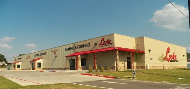
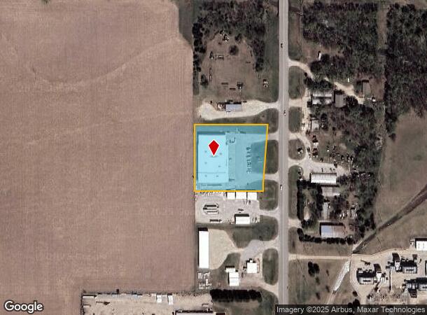
500 S Us Highway 81 Byp
139-30-0-00-11-017.00-0
S30, T19, R03, ACRES 2, CAP 873.5' N & 86.3' W OF SE/C SW4 FOR POB TH W304.8' N290' E327.3' SWLY290' TO POB
Wholesaleoutletdiscountstore
Mcpherson
X
Kansas
20113C0352E
2.05 AC
2024
Kansas Area
2025
Other Market Areas
788600
McPherson, KS
24,720 SF
DEMOGRAPHICS near 500 S Us Highway 81 Byp
1 Mile
3 Mile
5 Mile
2024 Total Population
1,745
14,934
15,401
2029 Population
1,754
14,916
15,376
Pop Growth 2024-2029
+ 0.52%
(0.12%)
(0.16%)
Average Age
37
40
40
2024 Total Households
666
5,979
6,165
HH Growth 2024-2029
+ 0.60%
(0.18%)
(0.23%)
Median Household Inc
$40,523
$61,135
$61,656
Avg Household Size
2.40
2.30
2.30
2024 Avg HH Vehicles
2.00
2.00
2.00
Median Home Value
$114,885
$172,709
$173,862
Median Year Built
1968
1976
1976
Nearby Places
- Restaurants
- Banks
- Shops
- Fitness
- Groceries
Nearby Properties
Address
Land Use
TOTAL SIZE
Lot Size
Zoning
Address
Land Use
TOTAL SIZE
Lot Size
Zoning
19,502 SF
39.67 AC
Address
Land Use
TOTAL SIZE
Lot Size
Zoning
2,400 SF
405.10 AC
Address
Land Use
TOTAL SIZE
Lot Size
Zoning
158,285 SF
43.11 AC
Address
Land Use
TOTAL SIZE
Lot Size
Zoning
10,384 SF
10.01 AC
Address
Land Use
TOTAL SIZE
Lot Size
Zoning
50,269 SF
5.27 AC
Address
Land Use
TOTAL SIZE
Lot Size
Zoning
2,080 SF
189.39 AC
Address
Land Use
TOTAL SIZE
Lot Size
Zoning
15,083 SF
15.74 AC
Address
Land Use
TOTAL SIZE
Lot Size
Zoning
125,666 SF
7.56 AC
Address
Land Use
TOTAL SIZE
Lot Size
Zoning
64,152 SF
5.09 AC
Address
Land Use
TOTAL SIZE
Lot Size
Zoning
49,496 SF
9.83 AC
Address
Land Use
TOTAL SIZE
Lot Size
Zoning
52,060 SF
17.13 AC
Address
Land Use
TOTAL SIZE
Lot Size
Zoning
31,840 SF
4.44 AC
Address
Land Use
TOTAL SIZE
Lot Size
Zoning
25,777 SF
4.25 AC
I2
Address
Land Use
TOTAL SIZE
Lot Size
Zoning
55,426 SF
2.77 AC
Address
Land Use
TOTAL SIZE
Lot Size
Zoning
32,489 SF
0.67 AC
B3
Address
Land Use
TOTAL SIZE
Lot Size
Zoning
51,052 SF
3.51 AC
Address
Land Use
TOTAL SIZE
Lot Size
Zoning
565 SF
54.98 AC
Address
Land Use
TOTAL SIZE
Lot Size
Zoning
42,112 SF
6.24 AC
Address
Land Use
TOTAL SIZE
Lot Size
Zoning
38,200 SF
3.33 AC
R2
Address
Land Use
TOTAL SIZE
Lot Size
Zoning
27,835 SF
4.81 AC
I2
Address
Land Use
TOTAL SIZE
Lot Size
Zoning
16,296 SF
9.11 AC
Address
Land Use
TOTAL SIZE
Lot Size
Zoning
5,000 SF
55.21 AC
Address
Land Use
TOTAL SIZE
Lot Size
Zoning
20,620 SF
9.97 AC
Address
Land Use
TOTAL SIZE
Lot Size
Zoning
23,666 SF
1.18 AC
Address
Land Use
TOTAL SIZE
Lot Size
Zoning
18,918 SF
2.34 AC
Address
Land Use
TOTAL SIZE
Lot Size
Zoning
25,916 SF
0.25 AC
B3
Address
Land Use
TOTAL SIZE
Lot Size
Zoning
46,543 SF
3.63 AC
R1
Address
Land Use
TOTAL SIZE
Lot Size
Zoning
18,060 SF
5.04 AC
Address
Land Use
TOTAL SIZE
Lot Size
Zoning
2,490 SF
18.23 AC
Address
Land Use
TOTAL SIZE
Lot Size
Zoning
32,240 SF
1.73 AC
The World's #1 Commercial Real Estate Marketplace
Connect with us
© 2025 CoStar Group
The information above has been obtained from sources believed reliable. While we do not doubt its accuracy we have not verified it and make no guarantee, warranty or representation about it. It is your responsibility to independently confirm its accuracy and completeness. Any projections, opinions, assumptions, or estimates used are for example only and do not represent the current or future performance of the property. The value of this transaction to you depends on tax and other factors which should be evaluated by your tax, financial, and legal advisors. You and your advisors should conduct a careful, independent investigation of the property to determine to your satisfaction the suitability of the property for your needs.