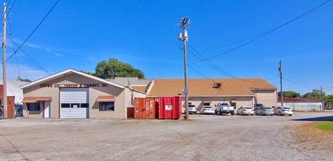
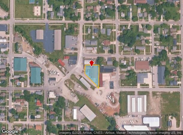
Property Record
500 Sheridan St, Crown Point, IN 46307


NEARBY LISTINGS FOR SALE OR LEASE
Property Detail
500 Sheridan St
Chicago-Naperville-Elgin, IL-IN-WI
Railroad Addition
45-16-05-481-002.000-042
RAILROAD ADD. BL.18 LOTS 1,2,3 & S.13FT OF LOT 4 & NLY TRI. PT. OF VAC. ADJ. PO RTER ST.
Lightindustrial
Lake
X
Indiana
18089C0261E
1,2,3
2023
0.56 AC
2024
Indiana
043004
Chicago
12,026 SF
DEMOGRAPHICS near 500 Sheridan St
1 Mile
3 Mile
5 Mile
2024 Total Population
8,514
42,081
85,989
2029 Population
8,493
42,214
86,394
Pop Growth 2024-2029
(0.25%)
+ 0.32%
+ 0.47%
Average Age
42
42
41
2024 Total Households
3,627
16,497
33,188
HH Growth 2024-2029
(0.30%)
+ 0.31%
+ 0.45%
Median Household Inc
$69,419
$83,398
$80,540
Avg Household Size
2.30
2.40
2.50
2024 Avg HH Vehicles
2.00
2.00
2.00
Median Home Value
$213,375
$254,594
$250,635
Median Year Built
1972
1993
1990
Nearby Places
Map Layers
Map Styles
 Street
 Aerial
- Restaurants
- Banks
- Shops
- Fitness
- Groceries
PUBLIC TRANSPORTATION
AIRPORT
Chicago Midway International
DRIVE
WALK
Distance
Chicago Midway International
67 min
40.9 mi
SALE & LEASE HISTORY
LISTING DATE
SALE/LEASE

Sep 23, 2016
For Sale
Dec 13, 2016
For Lease
Dec 13, 2016
For Sale
Nearby Properties
Address
Land Use
TOTAL SIZE
Lot Size
Zoning
Address
Land Use
TOTAL SIZE
Lot Size
Zoning
565,253 SF
59.49 AC
Address
Land Use
TOTAL SIZE
Lot Size
Zoning
642,771 SF
37.52 AC
Address
Land Use
TOTAL SIZE
Lot Size
Zoning
598,983 SF
88 AC
Address
Land Use
TOTAL SIZE
Lot Size
Zoning
129,204 SF
16.57 AC
Address
Land Use
TOTAL SIZE
Lot Size
Zoning
536,896 SF
20.08 AC
Address
Land Use
TOTAL SIZE
Lot Size
Zoning
377,878 SF
21.58 AC
Address
Land Use
TOTAL SIZE
Lot Size
Zoning
184,544 SF
16.76 AC
Address
Land Use
TOTAL SIZE
Lot Size
Zoning
324,724 SF
17.30 AC
Address
Land Use
TOTAL SIZE
Lot Size
Zoning
111,453 SF
15.21 AC
Address
Land Use
TOTAL SIZE
Lot Size
Zoning
263,968 SF
27.86 AC
Address
Land Use
TOTAL SIZE
Lot Size
Zoning
1,002,000 SF
60.96 AC
Address
Land Use
TOTAL SIZE
Lot Size
Zoning
304,425 SF
18.45 AC
Address
Land Use
TOTAL SIZE
Lot Size
Zoning
133,291 SF
R33
Address
Land Use
TOTAL SIZE
Lot Size
Zoning
236,904 SF
11.30 AC
R33
Address
Land Use
TOTAL SIZE
Lot Size
Zoning
276,540 SF
21.16 AC
Address
Land Use
TOTAL SIZE
Lot Size
Zoning
428,008 SF
54.72 AC
Address
Land Use
TOTAL SIZE
Lot Size
Zoning
143,060 SF
33.82 AC
Address
Land Use
TOTAL SIZE
Lot Size
Zoning
89,578 SF
2.59 AC
Address
Land Use
TOTAL SIZE
Lot Size
Zoning
63,992 SF
8.07 AC
Address
Land Use
TOTAL SIZE
Lot Size
Zoning
40,890 SF
11.27 AC
Address
Land Use
TOTAL SIZE
Lot Size
Zoning
123,316 SF
14.88 AC
R33
Address
Land Use
TOTAL SIZE
Lot Size
Zoning
61,318 SF
15.79 AC
R33
Address
Land Use
TOTAL SIZE
Lot Size
Zoning
92,823 SF
8.56 AC
Address
Land Use
TOTAL SIZE
Lot Size
Zoning
94,527 SF
6.10 AC
R33
Address
Land Use
TOTAL SIZE
Lot Size
Zoning
59,824 SF
5.29 AC
R33
Address
Land Use
TOTAL SIZE
Lot Size
Zoning
71,786 SF
9.20 AC
R33
Address
Land Use
TOTAL SIZE
Lot Size
Zoning
125,172 SF
5.57 AC
R33
Address
Land Use
TOTAL SIZE
Lot Size
Zoning
55,149 SF
2.76 AC
Address
Land Use
TOTAL SIZE
Lot Size
Zoning
85,898 SF
18.29 AC
R33
Address
Land Use
TOTAL SIZE
Lot Size
Zoning
48,658 SF
6.64 AC
R33
The World's #1 Commercial Real Estate Marketplace
Connect with us
© 2025 CoStar Group
The information above has been obtained from sources believed reliable. While we do not doubt its accuracy we have not verified it and make no guarantee, warranty or representation about it. It is your responsibility to independently confirm its accuracy and completeness. Any projections, opinions, assumptions, or estimates used are for example only and do not represent the current or future performance of the property. The value of this transaction to you depends on tax and other factors which should be evaluated by your tax, financial, and legal advisors. You and your advisors should conduct a careful, independent investigation of the property to determine to your satisfaction the suitability of the property for your needs.