Property Record
500 Thornton Rd, Lithia Springs, GA 30122

Current Lease Availabilities
NEARBY LISTINGS FOR SALE OR LEASE
Property Detail
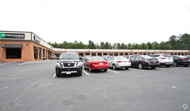
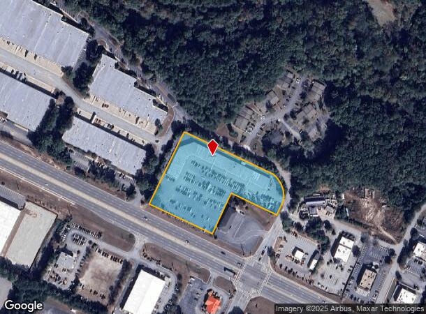
500 Thornton Rd
3182-03-7-0-008
Westfork Business Park - A
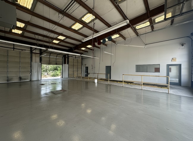
Warehouse
BLDG/4.254 AC, THORNTON RD (CAR CARE SERVICE
X
Douglas
13067C0192H
Georgia
2024
4.25 AC
2024
Villa Rica/W Outlying
080106
Atlanta
30,180 SF
Atlanta-Sandy Springs-Roswell, GA
DEMOGRAPHICS near 500 Thornton Rd
1 Mile
3 Mile
5 Mile
2024 Total Population
6,515
45,900
114,313
2029 Population
6,752
47,334
117,619
Pop Growth 2024-2029
+ 3.64%
+ 3.12%
+ 2.89%
Average Age
34
37
37
2024 Total Households
2,854
17,356
42,520
HH Growth 2024-2029
+ 3.82%
+ 3.16%
+ 2.90%
Median Household Inc
$48,140
$57,930
$61,882
Avg Household Size
2.30
2.60
2.60
2024 Avg HH Vehicles
2.00
2.00
2.00
Median Home Value
$197,133
$187,788
$209,257
Median Year Built
1994
1988
1987
Nearby Places
Map Layers
Map Styles
 Street
 Aerial
- Restaurants
- Banks
- Shops
- Fitness
- Groceries
PUBLIC TRANSPORTATION
AIRPORT
Hartsfield - Jackson Atlanta International
DRIVE
WALK
Distance
Hartsfield - Jackson Atlanta International
34 min
23.4 mi
Freight Ports
Georgia Ports - Savannah
DRIVE
WALK
Distance
Georgia Ports - Savannah
297 min
262.7 mi
Nearby Properties
Address
Land Use
TOTAL SIZE
Lot Size
Zoning
Address
Land Use
TOTAL SIZE
Lot Size
Zoning
840,110 SF
53.36 AC
PUD
Address
Land Use
TOTAL SIZE
Lot Size
Zoning
320,073 SF
38.78 AC
R-MF
Address
Land Use
TOTAL SIZE
Lot Size
Zoning
789,717 SF
68.55 AC
LI
Address
Land Use
TOTAL SIZE
Lot Size
Zoning
417,860 SF
40.32 AC
LI
Address
Land Use
TOTAL SIZE
Lot Size
Zoning
330,754 SF
27.25 AC
R-6
Address
Land Use
TOTAL SIZE
Lot Size
Zoning
318,456 SF
30.91 AC
R-MF
Address
Land Use
TOTAL SIZE
Lot Size
Zoning
222,846 SF
50.74 AC
R-6
Address
Land Use
TOTAL SIZE
Lot Size
Zoning
307,169 SF
30.13 AC
LI
Address
Land Use
TOTAL SIZE
Lot Size
Zoning
285,933 SF
46.22 AC
R-MF
Address
Land Use
TOTAL SIZE
Lot Size
Zoning
494,858 SF
43.29 AC
IL
Address
Land Use
TOTAL SIZE
Lot Size
Zoning
281,844 SF
38.66 AC
R-MF
Address
Land Use
TOTAL SIZE
Lot Size
Zoning
603,952 SF
37.71 AC
IL
Address
Land Use
TOTAL SIZE
Lot Size
Zoning
538,748 SF
35.64 AC
LI
Address
Land Use
TOTAL SIZE
Lot Size
Zoning
245,812 SF
30.90 AC
DCD
Address
Land Use
TOTAL SIZE
Lot Size
Zoning
490,726 SF
50.62 AC
LI-R
Address
Land Use
TOTAL SIZE
Lot Size
Zoning
527,000 SF
30.38 AC
LI
Address
Land Use
TOTAL SIZE
Lot Size
Zoning
Address
Land Use
TOTAL SIZE
Lot Size
Zoning
240,612 SF
23.22 AC
R-6
Address
Land Use
TOTAL SIZE
Lot Size
Zoning
635,664 SF
35.94 AC
5
Address
Land Use
TOTAL SIZE
Lot Size
Zoning
400,000 SF
66.21 AC
IL
Address
Land Use
TOTAL SIZE
Lot Size
Zoning
311,073 SF
56.51 AC
LI
Address
Land Use
TOTAL SIZE
Lot Size
Zoning
380,000 SF
33.97 AC
IL
Address
Land Use
TOTAL SIZE
Lot Size
Zoning
151,436 SF
11.42 AC
RM-12
Address
Land Use
TOTAL SIZE
Lot Size
Zoning
343,360 SF
26.72 AC
LI
Address
Land Use
TOTAL SIZE
Lot Size
Zoning
280,670 SF
23 AC
PVC
Address
Land Use
TOTAL SIZE
Lot Size
Zoning
283,998 SF
41.22 AC
LI-R
Address
Land Use
TOTAL SIZE
Lot Size
Zoning
312,093 SF
19.79 AC
PUD
Address
Land Use
TOTAL SIZE
Lot Size
Zoning
15.98 AC
LI
Address
Land Use
TOTAL SIZE
Lot Size
Zoning
261,930 SF
21.83 AC
R-A
Address
Land Use
TOTAL SIZE
Lot Size
Zoning
312,240 SF
24.58 AC
PUD
The World's #1 Commercial Real Estate Marketplace
Connect with us
© 2026 CoStar Group
The information above has been obtained from sources believed reliable. While we do not doubt its accuracy we have not verified it and make no guarantee, warranty or representation about it. It is your responsibility to independently confirm its accuracy and completeness. Any projections, opinions, assumptions, or estimates used are for example only and do not represent the current or future performance of the property. The value of this transaction to you depends on tax and other factors which should be evaluated by your tax, financial, and legal advisors. You and your advisors should conduct a careful, independent investigation of the property to determine to your satisfaction the suitability of the property for your needs.