Property Record
500 Us Highway 62 W, Princeton, KY 42445

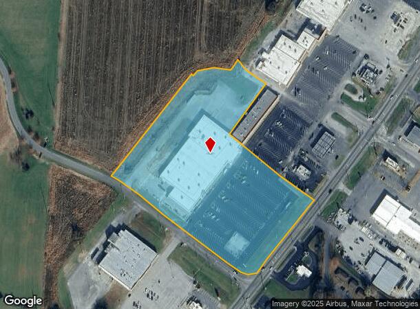
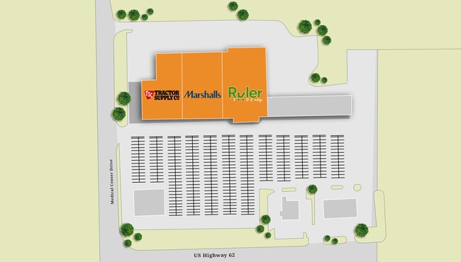
This Property Is For Sale
NEARBY LISTINGS FOR SALE OR LEASE
-
-
View all Princeton listings for sale on LoopNet.com
Property Detail
500 Us Highway 62 W
38-9S-1
BLDG & 9.581 ACRES
Commercialnec
Caldwell
X
Kentucky
21033C0235D
9.58 AC
2025
Kentucky West Area
2025
Other Market Areas
920200
DEMOGRAPHICS near 500 Us Highway 62 W
1 Mile
3 Mile
5 Mile
2024 Total Population
1,743
6,680
7,980
2029 Population
1,727
6,595
7,892
Pop Growth 2024-2029
(0.92%)
(1.27%)
(1.10%)
Average Age
42
41
42
2024 Total Households
752
2,830
3,357
HH Growth 2024-2029
(0.93%)
(1.31%)
(1.13%)
Median Household Inc
$42,833
$45,166
$45,762
Avg Household Size
2.20
2.30
2.30
2024 Avg HH Vehicles
2.00
2.00
2.00
Median Home Value
$83,646
$90,742
$96,166
Median Year Built
1959
1961
1965
Nearby Places
Map Layers
Map Styles
 Street
 Aerial
- Restaurants
- Banks
- Shops
- Fitness
- Groceries
Nearby Properties
Address
Land Use
TOTAL SIZE
Lot Size
Zoning
Address
Land Use
TOTAL SIZE
Lot Size
Zoning
155,089 SF
22.87 AC
Address
Land Use
TOTAL SIZE
Lot Size
Zoning
5.77 AC
Address
Land Use
TOTAL SIZE
Lot Size
Zoning
1,936 SF
5.77 AC
Address
Land Use
TOTAL SIZE
Lot Size
Zoning
Address
Land Use
TOTAL SIZE
Lot Size
Zoning
Address
Land Use
TOTAL SIZE
Lot Size
Zoning
Address
Land Use
TOTAL SIZE
Lot Size
Zoning
2,982 SF
0.73 AC
Address
Land Use
TOTAL SIZE
Lot Size
Zoning
0.67 AC
Address
Land Use
TOTAL SIZE
Lot Size
Zoning
2,714 SF
0.92 AC
Address
Land Use
TOTAL SIZE
Lot Size
Zoning
2,436 SF
0.65 AC
Address
Land Use
TOTAL SIZE
Lot Size
Zoning
2.34 AC
Address
Land Use
TOTAL SIZE
Lot Size
Zoning
0.70 AC
Address
Land Use
TOTAL SIZE
Lot Size
Zoning
Address
Land Use
TOTAL SIZE
Lot Size
Zoning
Address
Land Use
TOTAL SIZE
Lot Size
Zoning
Address
Land Use
TOTAL SIZE
Lot Size
Zoning
4,820 SF
1.95 AC
Address
Land Use
TOTAL SIZE
Lot Size
Zoning
48,000 SF
7.78 AC
Address
Land Use
TOTAL SIZE
Lot Size
Zoning
3,260 SF
2.37 AC
Address
Land Use
TOTAL SIZE
Lot Size
Zoning
15,718 SF
1.42 AC
Address
Land Use
TOTAL SIZE
Lot Size
Zoning
2,430 SF
0.52 AC
Address
Land Use
TOTAL SIZE
Lot Size
Zoning
Address
Land Use
TOTAL SIZE
Lot Size
Zoning
5,362 SF
1.90 AC
Address
Land Use
TOTAL SIZE
Lot Size
Zoning
6,400 SF
0.65 AC
Address
Land Use
TOTAL SIZE
Lot Size
Zoning
12.32 AC
Address
Land Use
TOTAL SIZE
Lot Size
Zoning
10.74 AC
Address
Land Use
TOTAL SIZE
Lot Size
Zoning
Address
Land Use
TOTAL SIZE
Lot Size
Zoning
12,296 SF
1.68 AC
Address
Land Use
TOTAL SIZE
Lot Size
Zoning
19,392 SF
2 AC
Address
Land Use
TOTAL SIZE
Lot Size
Zoning
1.14 AC
Address
Land Use
TOTAL SIZE
Lot Size
Zoning
1,842 SF
1.38 AC
The World's #1 Commercial Real Estate Marketplace
Connect with us
© 2026 CoStar Group
The information above has been obtained from sources believed reliable. While we do not doubt its accuracy we have not verified it and make no guarantee, warranty or representation about it. It is your responsibility to independently confirm its accuracy and completeness. Any projections, opinions, assumptions, or estimates used are for example only and do not represent the current or future performance of the property. The value of this transaction to you depends on tax and other factors which should be evaluated by your tax, financial, and legal advisors. You and your advisors should conduct a careful, independent investigation of the property to determine to your satisfaction the suitability of the property for your needs.