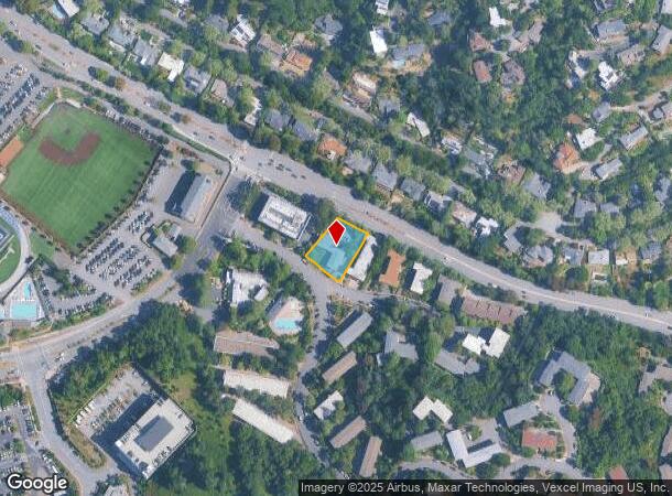
Property Record
500 Via Hidalgo, Greenbrae, CA 94904


This Property Is For Sale
NEARBY LISTINGS FOR SALE OR LEASE
Property Detail
500 Via Hidalgo
022-024-02
Bon Air Sub #3
Multifamilydwelling
Marin
X
California
06041C0458F
26
2024
0.33 AC
2025
Outer San Rafael/Larkspur
119201
North Bay/Santa Rosa
5,472 SF
San Rafael, CA
DEMOGRAPHICS near 500 Via Hidalgo
1 Mile
3 Mile
5 Mile
2024 Total Population
13,932
79,997
152,130
2029 Population
13,562
77,691
147,821
Pop Growth 2024-2029
(2.66%)
(2.88%)
(2.83%)
Average Age
47
43
45
2024 Total Households
6,109
31,215
60,677
HH Growth 2024-2029
(2.70%)
(2.85%)
(2.83%)
Median Household Inc
$124,129
$120,745
$128,452
Avg Household Size
2.20
2.50
2.40
2024 Avg HH Vehicles
2.00
2.00
2.00
Median Home Value
$1,115,317
$1,113,649
$1,103,031
Median Year Built
1965
1961
1963
Nearby Places
Map Layers
Map Styles
 Street
 Aerial
- Restaurants
- Banks
- Shops
- Fitness
- Groceries
PUBLIC TRANSPORTATION
COMMUTER RAIL
Larkspur Smart (Main Line - Sonoma Marin Area Rail Transit)
DRIVE
WALK
Distance
Larkspur Smart (Main Line - Sonoma Marin Area Rail Transit)
5 min
1.7 mi
San Rafael Smart (Main Line - Sonoma Marin Area Rail Transit)
DRIVE
WALK
Distance
San Rafael Smart (Main Line - Sonoma Marin Area Rail Transit)
7 min
3.6 mi
AIRPORT
San Francisco International
DRIVE
WALK
Distance
San Francisco International
48 min
29.6 mi
Metro Oakland International
DRIVE
WALK
Distance
Metro Oakland International
43 min
31.2 mi
Freight Ports
Port of Richmond
DRIVE
WALK
Distance
Port of Richmond
21 min
11.9 mi
Nearby Properties
Address
Land Use
TOTAL SIZE
Lot Size
Zoning
Address
Land Use
TOTAL SIZE
Lot Size
Zoning
271,212 SF
15.87 AC
Address
Land Use
TOTAL SIZE
Lot Size
Zoning
217,791 SF
4.51 AC
Address
Land Use
TOTAL SIZE
Lot Size
Zoning
87,058 SF
1.33 AC
Address
Land Use
TOTAL SIZE
Lot Size
Zoning
91,151 SF
3.15 AC
Address
Land Use
TOTAL SIZE
Lot Size
Zoning
180,000 SF
15.92 AC
Address
Land Use
TOTAL SIZE
Lot Size
Zoning
132,969 SF
9.09 AC
Address
Land Use
TOTAL SIZE
Lot Size
Zoning
119,185 SF
4.31 AC
Address
Land Use
TOTAL SIZE
Lot Size
Zoning
109,944 SF
5.73 AC
Address
Land Use
TOTAL SIZE
Lot Size
Zoning
147,502 SF
1.02 AC
Address
Land Use
TOTAL SIZE
Lot Size
Zoning
218,521 SF
26.79 AC
Address
Land Use
TOTAL SIZE
Lot Size
Zoning
127,504 SF
8.49 AC
Address
Land Use
TOTAL SIZE
Lot Size
Zoning
12.57 AC
Address
Land Use
TOTAL SIZE
Lot Size
Zoning
91,158 SF
1.89 AC
Address
Land Use
TOTAL SIZE
Lot Size
Zoning
79,995 SF
3.15 AC
Address
Land Use
TOTAL SIZE
Lot Size
Zoning
119,061 SF
5.90 AC
Address
Land Use
TOTAL SIZE
Lot Size
Zoning
15.91 AC
SPD
Address
Land Use
TOTAL SIZE
Lot Size
Zoning
72,870 SF
3.51 AC
Address
Land Use
TOTAL SIZE
Lot Size
Zoning
94,745 SF
1.46 AC
Address
Land Use
TOTAL SIZE
Lot Size
Zoning
234,922 SF
6 AC
Address
Land Use
TOTAL SIZE
Lot Size
Zoning
81,894 SF
5.91 AC
Address
Land Use
TOTAL SIZE
Lot Size
Zoning
71,527 SF
1.86 AC
Address
Land Use
TOTAL SIZE
Lot Size
Zoning
84,245 SF
2.62 AC
Address
Land Use
TOTAL SIZE
Lot Size
Zoning
97,410 SF
5.97 AC
Address
Land Use
TOTAL SIZE
Lot Size
Zoning
177,460 SF
13 AC
Address
Land Use
TOTAL SIZE
Lot Size
Zoning
11,830 SF
0.65 AC
Address
Land Use
TOTAL SIZE
Lot Size
Zoning
138,861 SF
15.83 AC
Address
Land Use
TOTAL SIZE
Lot Size
Zoning
82,206 SF
3.67 AC
Address
Land Use
TOTAL SIZE
Lot Size
Zoning
87,840 SF
1.19 AC
Address
Land Use
TOTAL SIZE
Lot Size
Zoning
Address
Land Use
TOTAL SIZE
Lot Size
Zoning
54,189 SF
4.80 AC
The World's #1 Commercial Real Estate Marketplace
Connect with us
© 2025 CoStar Group
The information above has been obtained from sources believed reliable. While we do not doubt its accuracy we have not verified it and make no guarantee, warranty or representation about it. It is your responsibility to independently confirm its accuracy and completeness. Any projections, opinions, assumptions, or estimates used are for example only and do not represent the current or future performance of the property. The value of this transaction to you depends on tax and other factors which should be evaluated by your tax, financial, and legal advisors. You and your advisors should conduct a careful, independent investigation of the property to determine to your satisfaction the suitability of the property for your needs.