Property Record
500 W Daniels St, Ozark, MO 65721
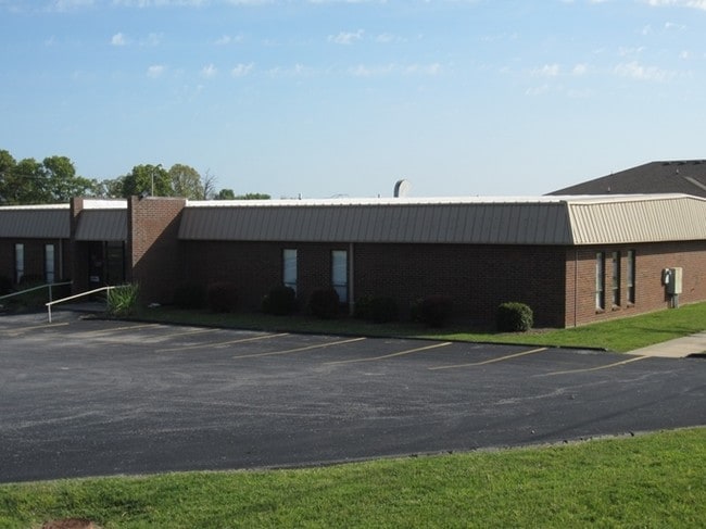


This Property Is For Sale
Property Detail
500 W Daniels St
11-0.7-35-002-001-011.000
BEG 1163.52 NE & 48.27 E SWC NW4, TH NE 175 SE 170 SW 175 NW TO POB
Officebuilding
Christian
B and X Area of moderate flood hazard, usually the area between the limits of the 100-year and 500-year floods.
Missouri
0
1 AC
2025
East Christian County
020303
Springfield
7,100 SF
Springfield, MO
NEARBY LISTINGS FOR SALE OR LEASE
-
-
View all Ozark listings for sale on LoopNet.com
DEMOGRAPHICS near 500 W Daniels St
1 mile
3 mile
5 mile
2025 Total Population
5,343
18,119
36,331
2030 Population
5,669
19,192
38,529
Pop Growth 2025-2030
+ 6.10%
+ 5.92%
+ 6.05%
Average Age
37
38
39
2025 Total Households
1,968
6,633
13,329
HH Growth 2025-2030
+ 6.15%
+ 5.99%
+ 6.09%
Median Household Inc
$66,877
$74,424
$79,590
Avg Household Size
2.70
2.60
2.70
2025 Avg HH Vehicles
2.00
2.00
2.00
Median Home Value
$232,106
$272,889
$320,358
Median Year Built
1993
1996
1999
Nearby Places
Map Layers
Map Styles
 Street
 Aerial
Layers
 Traffic
 Biking
Places
Listings with unknown addresses are not visible on the map
- Restaurants
- Banks
- Shops
- Fitness
- Groceries
PUBLIC TRANSPORTATION
AIRPORT
Springfield-Branson Ntl
Drive
Walk
Distance
Springfield-Branson Ntl
46 min
31.8 mi
Nearby Properties
Address
Land Use
TOTAL SIZE
Lot Size
Zoning
Address
Land Use
TOTAL SIZE
Lot Size
Zoning
6,000 SF
50.60 AC
Address
Land Use
TOTAL SIZE
Lot Size
Zoning
2,942 SF
17.41 AC
Address
Land Use
TOTAL SIZE
Lot Size
Zoning
33,019 SF
6.24 AC
Address
Land Use
TOTAL SIZE
Lot Size
Zoning
131,905 SF
17.94 AC
Address
Land Use
TOTAL SIZE
Lot Size
Zoning
4,800 SF
10.57 AC
Address
Land Use
TOTAL SIZE
Lot Size
Zoning
2,100 SF
20 AC
Address
Land Use
TOTAL SIZE
Lot Size
Zoning
77,079 SF
28.40 AC
Address
Land Use
TOTAL SIZE
Lot Size
Zoning
48,227 SF
3.07 AC
Address
Land Use
TOTAL SIZE
Lot Size
Zoning
53,125 SF
8.01 AC
Address
Land Use
TOTAL SIZE
Lot Size
Zoning
38,524 SF
6.54 AC
Address
Land Use
TOTAL SIZE
Lot Size
Zoning
13,634 SF
3.51 AC
Address
Land Use
TOTAL SIZE
Lot Size
Zoning
41,000 SF
4.50 AC
Address
Land Use
TOTAL SIZE
Lot Size
Zoning
23,625 SF
7.98 AC
Address
Land Use
TOTAL SIZE
Lot Size
Zoning
Address
Land Use
TOTAL SIZE
Lot Size
Zoning
7,950 SF
8.05 AC
Address
Land Use
TOTAL SIZE
Lot Size
Zoning
3,003 SF
6.46 AC
Address
Land Use
TOTAL SIZE
Lot Size
Zoning
20,765 SF
3 AC
Address
Land Use
TOTAL SIZE
Lot Size
Zoning
8,802 SF
5.26 AC
Address
Land Use
TOTAL SIZE
Lot Size
Zoning
5,760 SF
8.62 AC
Address
Land Use
TOTAL SIZE
Lot Size
Zoning
Address
Land Use
TOTAL SIZE
Lot Size
Zoning
23,112 SF
0.54 AC
Address
Land Use
TOTAL SIZE
Lot Size
Zoning
3,464 SF
13.34 AC
Address
Land Use
TOTAL SIZE
Lot Size
Zoning
28,000 SF
3.62 AC
Address
Land Use
TOTAL SIZE
Lot Size
Zoning
2,025 SF
4.89 AC
Address
Land Use
TOTAL SIZE
Lot Size
Zoning
1,476 SF
3.77 AC
Address
Land Use
TOTAL SIZE
Lot Size
Zoning
37,504 SF
6.12 AC
Address
Land Use
TOTAL SIZE
Lot Size
Zoning
1,996 SF
3.73 AC
Address
Land Use
TOTAL SIZE
Lot Size
Zoning
32,000 SF
3.11 AC
Address
Land Use
TOTAL SIZE
Lot Size
Zoning
3,664 SF
2.81 AC
Address
Land Use
TOTAL SIZE
Lot Size
Zoning
3,654 SF
2.11 AC
The World's #1 Commercial Real Estate Marketplace
Connect with us
© 2026 CoStar Group
The information above has been obtained from sources believed reliable. While we do not doubt its accuracy we have not verified it and make no guarantee, warranty or representation about it. It is your responsibility to independently confirm its accuracy and completeness. Any projections, opinions, assumptions, or estimates used are for example only and do not represent the current or future performance of the property. The value of this transaction to you depends on tax and other factors which should be evaluated by your tax, financial, and legal advisors. You and your advisors should conduct a careful, independent investigation of the property to determine to your satisfaction the suitability of the property for your needs.